
We are now a little more than 24 hours from Hurricane Florence making landfall along the North Carolina coastline. Currently, Hurricane Florence is a Category 3 hurricane with wind speeds sustained at 115 MPH. Over the next 24 hours, it is expected to strengthen before it makes landfall. Unfortunately, there is little doubt now that coastal areas of North Carolina and parts of the South Carolina coastline will be inhabitable for weeks, if not months following Hurricane Florence’s destruction.
What makes this hurricane unique and much more concerning versus other hurricanes, is the duration. Because there is a very strong high pressure to the north, this will cause Hurricane Florence to stall out and essentially sit and spin over the Carolina’s for 48-72 hours before exiting the area. For areas in Pennsylvania, Maryland, Virginia, Delaware, and New Jersey can thank the high pressure in place or we could of been talking about a much worse scenario for these areas. However, once that high pressure does move along, this will allow Hurricane Florence remnants to track north. The exact track of the remnants is a bit up in the air right now, but we will display two scenarios at the bottom of this article as there is some concern for flooding next week.
First off, here is the latest projected path of Hurricane Florence along with two potential extrapolated paths that Florence’s remnants might take: 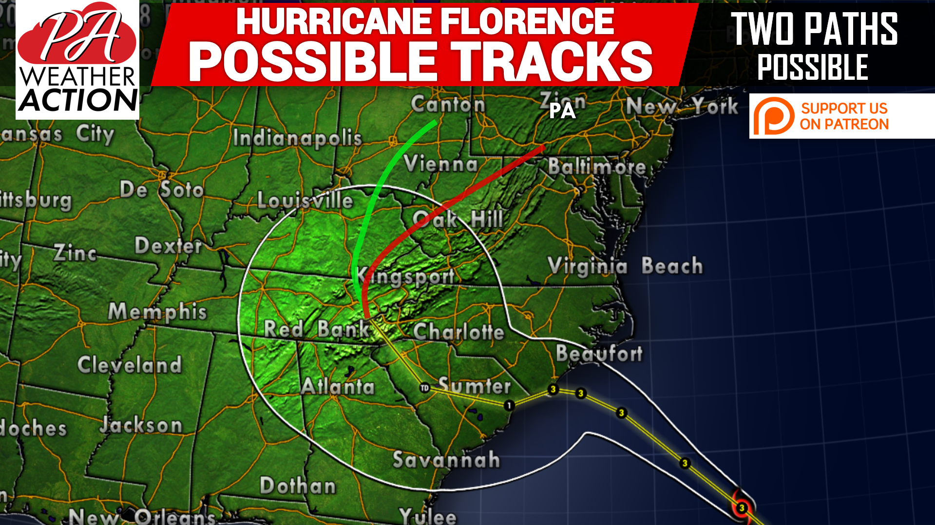
If Florence ends up taking the red path, which the latest European model is suggesting, this would allow for Pennsylvania to receive another heavy rain event next Tuesday into Wednesday of next week. We are not talking a foot of rainfall, but it will not take much for our to receive flooding with all the rain we have received this summer.
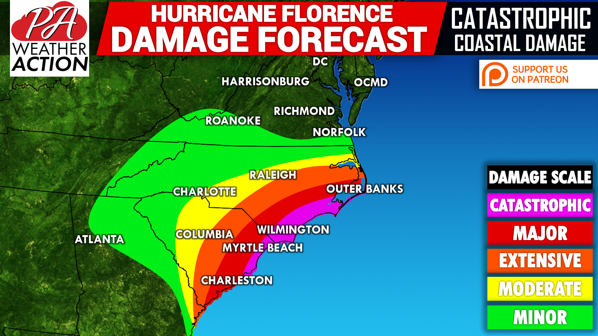
Latest Hurricane Florence Damage Map:
If you have family members in the extensive, major, or catastrophic zones, please tell them they have to evacuate if they have not already. Areas in the pink will not only see catastrophic damage from winds sustained well over 100 MPH, but also storm surge 5 to 10 feet is expected. That is not including the expected rainfall. Many of these areas will surpass 20 inches of rain, with locally up to 3 feet of rainfall right along the coastline. This includes places such as, Myrtle Beach, Wilmington, Jacksonville (North Carolina), as well as the Outer Banks.
For us locally here in Pennsylvania, we mentioned and outlined two possible tracks that Hurricane Florence’s remnants may take.Below are two scenarios with the potential impacts listed below.
FIRST SCENARIO (GREEN TRACK):
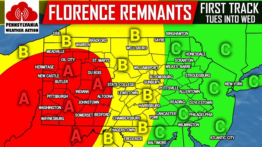
Area A: This area would have the greatest chance in our region to experience a flooding rainfall with this track. It is too early for specific amounts, given that the remnants will not reach our area until Tuesday and Wednesday of next week. With that being said, a few to several inches of rain is possible.
Area B: This area is under some threat for flooding rain from Florence’s remnants with this scenario. A couple inches of rain is possible Tuesday into Wednesday.
Area C: With this scenario, the flooding threat is rather limited for these areas. Upwards of an inch of rainfall is still possible Tuesday into Wednesday.
SECOND SCENARIO (RED TRACK):
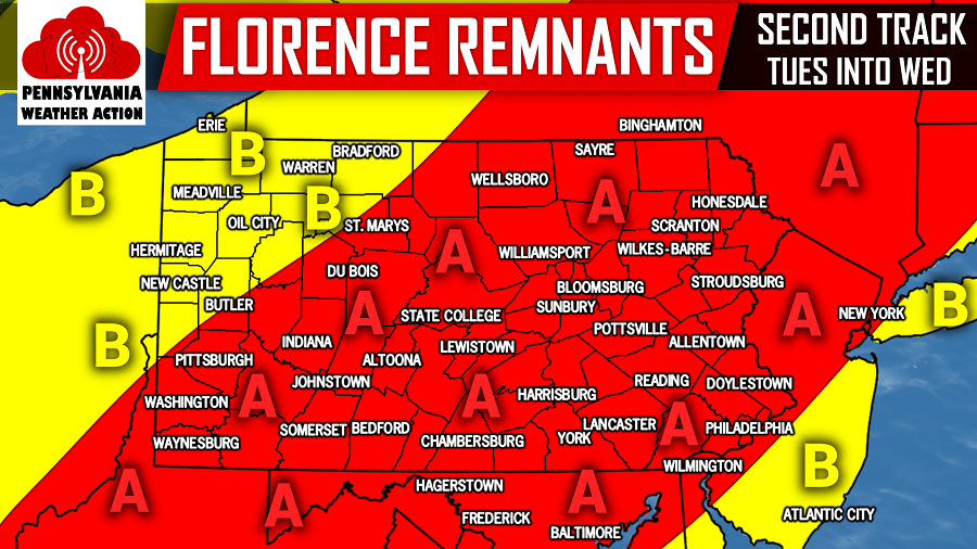
Area A: This area would have the greatest chance in our region to experience a flooding rainfall with this track. It is too early for specific amounts, given that the remnants will not reach our area until Tuesday and Wednesday of next week. With that being said, a few to several inches of rain is possible.
Area B: This area is under some threat for flooding rain from Florence’s remnants with this scenario. A couple inches of rain is possible Tuesday into Wednesday.
Obviously the second scenario/red track would be more troubling for our area. We do want to stress if we do experience any flooding, it will not be anywhere near as bad as what the Carolina’s are about to experience. So do not start panicking. The rainfall from Hurricane Florence next week, will not be any worse than the raining we have experienced this summer.
Like our page on Facebook for the latest forecast updates: Pennsylvania Weather Action’s Facebook page
Be sure to download our free app to stay ahead of Hurricane Florence, as well as the latest weather alerts and traffic conditions, click here: Pennsylvania Weather Action’s App
Share the article with your family and friends using our icon below, stay safe!
You must be logged in to post a comment.