
Our First Call Snowfall & Ice Forecast Has Bee Posted >>> FIRST CALL SNOWFALL & ICE FORECAST FOR THIS WEEKEND’S MAJOR WINTER STORM
All week we have been receiving questions regarding the rumor of a big winter storm this weekend. Well those rumors are in fact true. A major winter storm is likely to impact our state this weekend with all types of precipitation ranging from heavy snow, to sleet and freezing rain, and plain rain.
As it stands right now, the closer you live to the PA/NY border, the more likely it is you receive mostly, if not all snow. The farther southeast in the state you are, the more likely it is you will change over to rain after starting off as a period of wintry precipitation. For the areas that stay all snow, it is likely you will need more than a ruler to measure the snow. The worst part of this storm may not even be the snowfall, despite the hefty amounts. Ice is a huge concern. Wherever the gradient sets up between all snow and plain rain, these areas could receive a major ice storm.
We do want to be clear that we are still a full 3 days out from this storm impacting our region. So while we are confident in a major winter storm impacting the state, nothing is set in stone yet in terms of exact details.
The storm will begin to develop over the Texas Panhandle by Friday and will continue to push east into Arkansas. Where the storm tracks from here is still up in the air. Right now the GFS (American Model) is in its own boat by taking our storm into Southwest Pennsylvania, allowing for a brief snow to wintry mix to rain for just about everyone. While the rest of the models take the low pressure to our south into West Virginia or Virginia depending on which model you look at. This scenario is what we believe in which will allow for a more wintry solution than the GFS.
Regardless of precipitation type, timing seems to be fairly locked in. Precipitation looks to begin in Western Pennsylvania by late Saturday morning/Early Saturday afternoon and will overspread all of the state by Saturday evening. The worst travel conditions will be Saturday night through Sunday afternoon. There will be numerous road closures all throughout the state during this time. It is highly recommended you have a back up plan for any outdoor activities this weekend.
IMPACT MAP FOR THIS WEEKEND’S MAJOR WINTER STORM
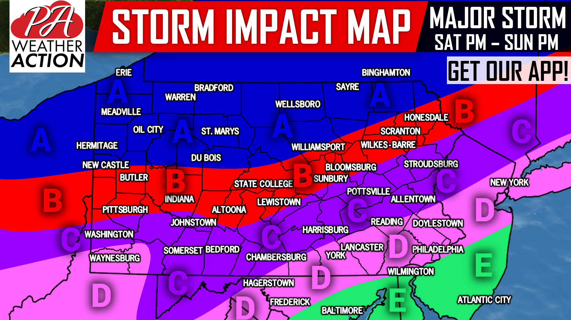
Area A: Major snowfall accumulations are possible in this region, as it is currently expected to stay all snow through the duration of this storm. The ice threat looks to be relatively low in this area. Much of this area is rural, and some roads may be impassable several days after the snow.
Area B: Major snowfall accumulations are possible, followed by light accumulations, as this area may turn to sleet and freezing rain for a short time before turning back to snow.
Area C: Significant snowfall accumulations are possible in the beginning of this storm, followed by what may be a prolonged period of sleet and/or freezing rain. This area is where our biggest concern for ice is, as ice accumulations could be significant.
Area D: Moderate snowfall accumulations are possible to begin this storm, followed by a period of sleet and freezing rain. Wintry precipitation may then switch to plain rain. Light to moderate ice accumulations possible.
Area E: Light snowfall accumulations are possible on the front end of this storm, possibly followed by a short period of mixed precipitation before turning to rain.
This is one of the toughest forecasts in a while due to model guidance constantly fluctuating. Be on the lookout for changes to the forecast in the next few days. Our First Call Forecast will be out on Thursday.
Remember to download our app to receive important forecast information on this major winter storm >>> PA Weather App Link
Be sure to share this major storm update with your friends and family using the button below, stay tuned!
You must be logged in to post a comment.