
Good Evening Everyone! We are onto storm #3 in this active weather pattern. Another round of rain and strong winds will sweep across the region tomorrow night into Saturday. Although not as powerful of a system as earlier this week, the last thing our region needs is rain and wind. Many rivers are still running at minor to moderate flood stage, and several thousand remain without power across our region.
Friday
Friday morning will begin with partly cloudy skies and temperatures in the low 30s. Cloud cover will move in around lunchtime, and temperatures will rise into the 40s by the afternoon.
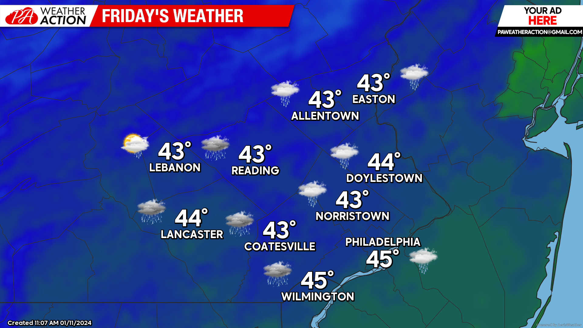 Precipitation will move into the area between 7-9 pm from SW to NE. The precipitation will be moderate to heavy at times into the overnight hours. Winds will increase as well after sunset. Expect winds out of the SE at 20-30mph with gusts up to 50mph. The heaviest rain will move through between 11pm and 1am with a peak in wind gusts at this time as well. Precipitation will end from west to east from 2-4am Saturday.
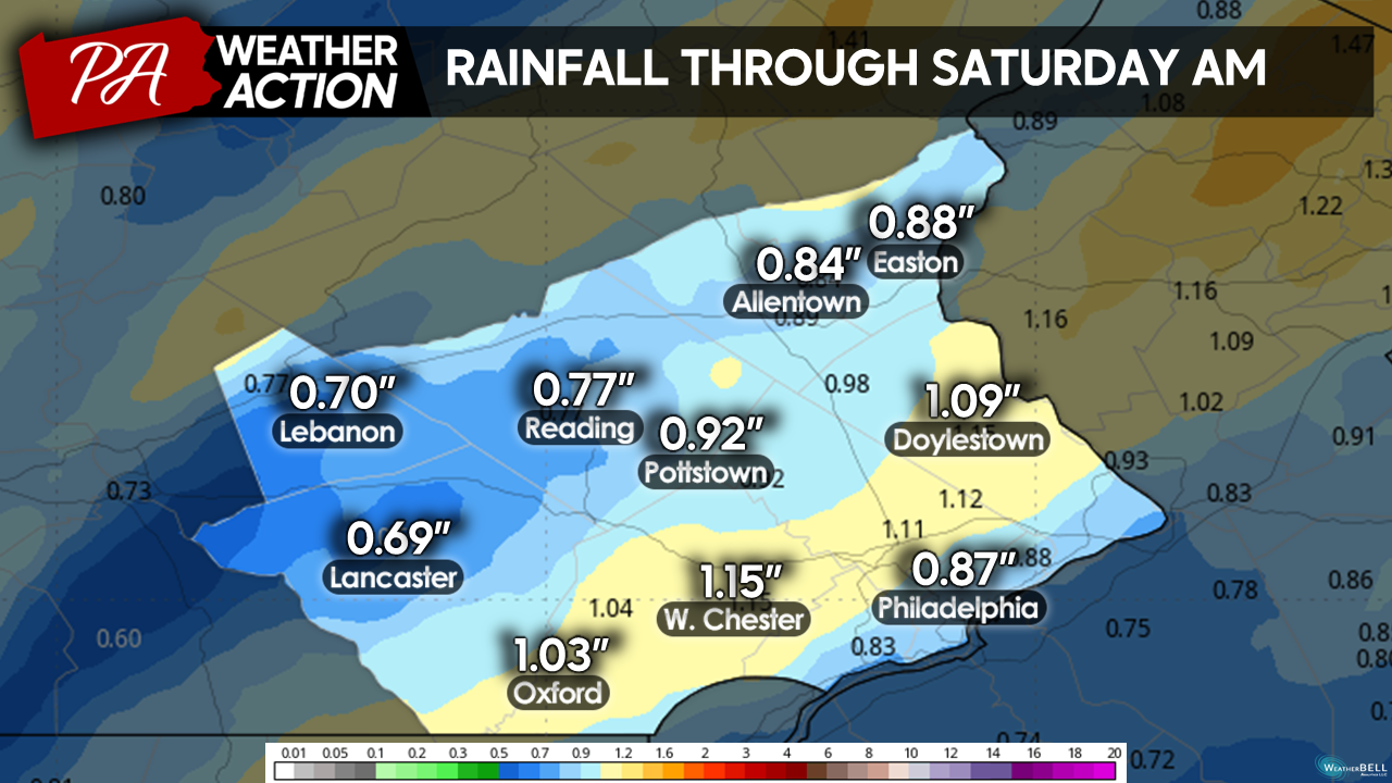
I am projecting between 0.5″-1.5″ to fall regionwide with this system, with SE locations most likely to see the higher totals. Here is a model estimate of rain totals across the region:
Although projections for rainfall are not as high as with Tuesday’s storm, rivers, and streams region-wide are already running near or above flood stage. Additional rainfall will only exacerbate flooding in areas impacted by river rise from Tuesday’s storm. For this reason, the National Weather Service has preemptively issued flood watches for Lehigh, Northampton, Bucks, Montgomery, Philadelphia, Delaware, and Chester counties.

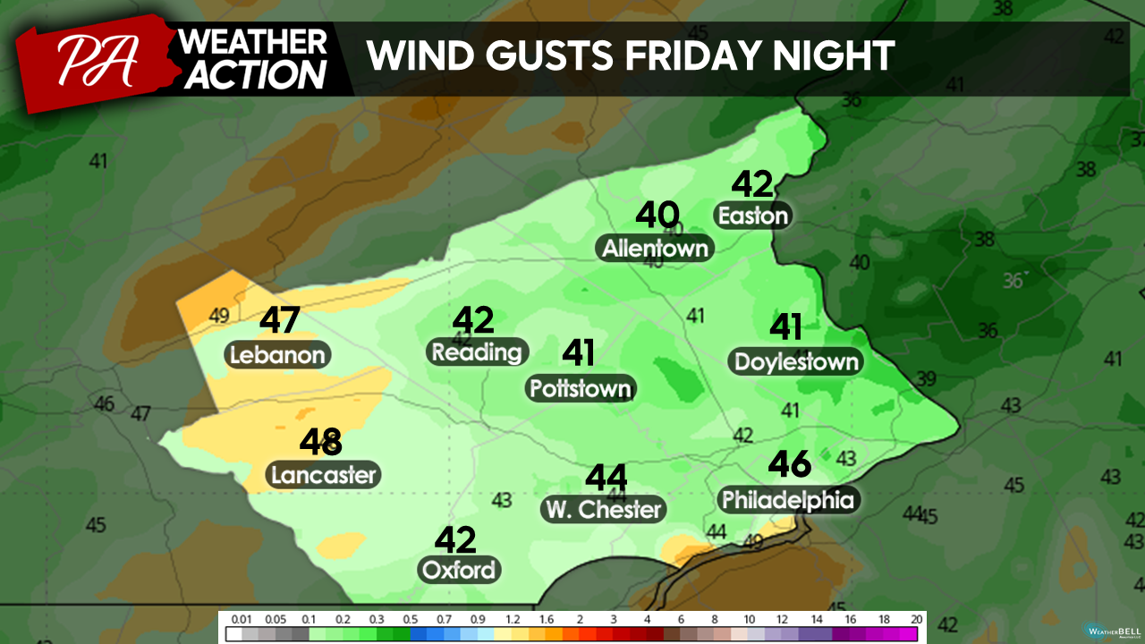
Additionally, winds will likely cause more problems for the region. Currently, several thousand customers across Chester and Delaware counties remain without power from Tuesday’s storm. While I don’t expect power outages to be as widespread in this storm, saturated soils and weakened trees from Tuesday’s storm will increase the risk of tree damage even if gusts aren’t as high. Here is a model projection of wind gusts across the area Friday Night:
Winds will prevail out of the SE before the storm passes by early Saturday morning. These onshore winds will increase tide levels in areas impacted by tidal flooding early this week. 1 to 2 feet of inundation is possible in low-lying areas along the Delaware River in Delaware, Philadelphia, and Southern Bucks counties. For this reason, the National Weather Service has once again issued Coastal Flood Warnings for these areas.

Saturday
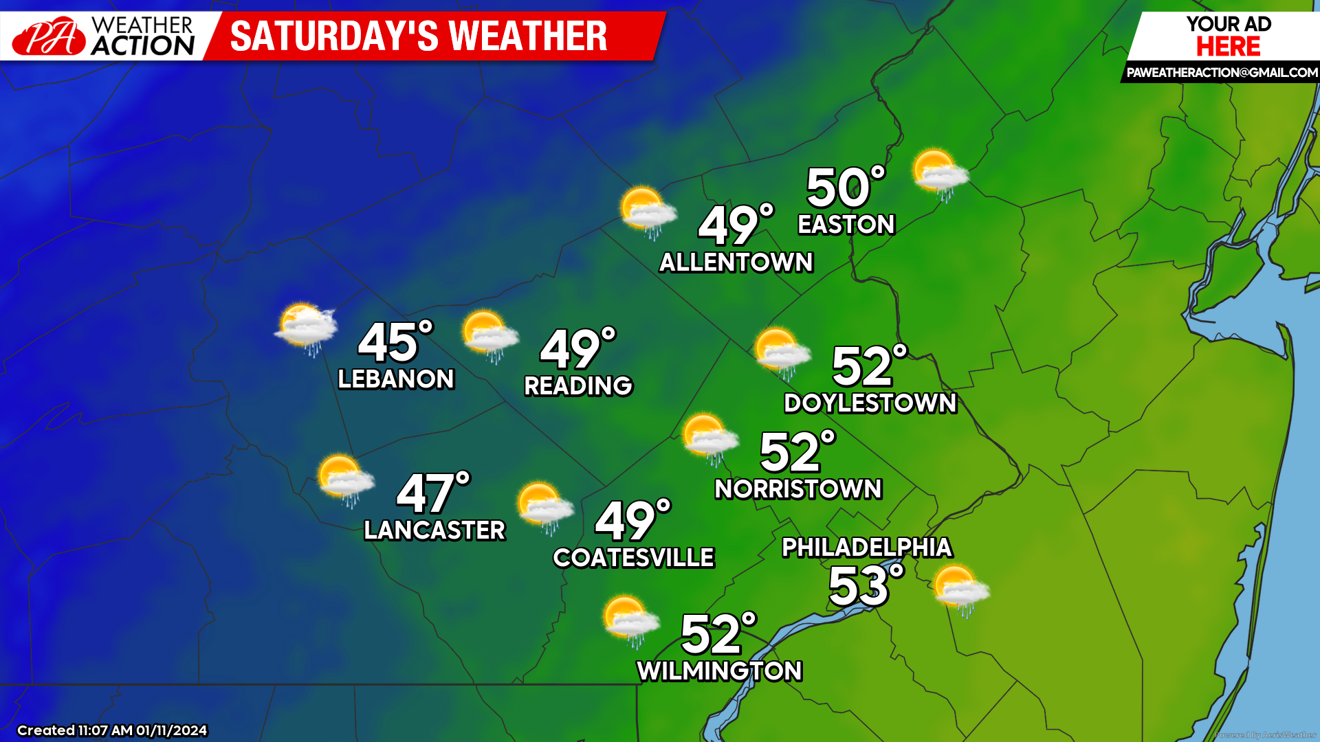
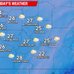
Friday night’s storm will clear the region before dawn on Saturday. However, this storm will usher in a prolonged period of colder than average weather. The longest and coldest stretch of weather we have seen thus far this winter. Expect partly sunny skies to start the day, with temperatures still mild in the mid-40s – low-50s. Blustery westerly winds will usher in colder air for the region throughout the day on Saturday. Wind gusts up to 40mph remain possible. Scattered showers will linger otherwise expect partly cloudy skies throughout the day. Temperatures will fall into the low-40s by the afternoon and will quickly fall through the 30s by the evening.
High temperatures below will be seen during the predawn hours on Saturday as our storm moves through and are not reflective of temperatures throughout most of the day.
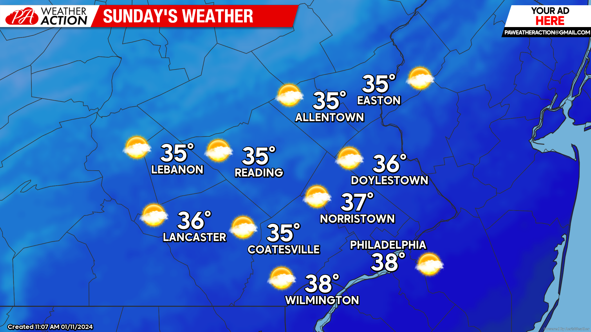
Sunday
Expect mostly sunny skies to start your Sunday with temperatures in the upper 20s to low 30s. A few scattered clouds will continue to filter throughout the day. Otherwise, expect a quiet but chilly day, with afternoon highs only reaching the mid-upper 30s. Winds will be out of the SW at 10-15mph keeping feels like temperatures in the 20s throughout the day.
Looking Ahead:
As mentioned, expect a prolonged period of below-average temperatures as we head into next week. With the colder weather, I am also tracking our potential next system, which offers our best shot at widespread wintry weather yet this winter. As of now, next Tuesday- Wednesday looks to be the timeframe for our potential winter weather. There is still much model disagreement with many different scenarios for our storm next week, so nothing is set in stone just yet. Over the coming days, models will come into better agreement, and I will post a blog detailing potential impacts from our system later this weekend or early next week. For now, it is best to focus on the weather at hand with tomorrow’s flooding and wind threat! If you have any questions or comments regarding the forecast, please let me know!
-Michael Woytowiez
You must be logged in to post a comment.