
If this was January, we would be forecasting a major snowstorm with multiple feet of snow across the heart of the state, but it’s not. Instead, a soggy weekend is expected which is unfortunate because many commencement ceremonies will have to be held indoors on Saturday. Mother’s Day will be mostly dry, with only Western PA escaping the cloudiness. Temperatures will remain cool, in the mid 50s to low 60s.
A low pressure system over the Ohio Valley will produce a long period of moderate rain across PA, starting tonight. The storm will be slow, as strong blocking-high pressure looms off the coast. The primary low pressure will push just south of the state Friday night, as rain continues. Some severe weather is expected south of our area, but for us just a few rumbles of thunder are possible. The low pressure will become elongated on Saturday, stretching from West Virginia to off the Delmarva coast. As a result, rain showers will continue until the low finally makes its way off the coast late Saturday night.
River Forecast Center Links:
Central & Eastern PA (MARFC) Link
Below is the Hi-Res NAM future radar for this event.
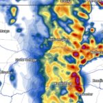
FRIDAY – SATURDAY RAINFALL FORECAST MAP

Area A: Between 3 – 4″ of rainfall expected. Many creeks and rivers in this region are forecast to rise near flood stage, but at this time no flooding is expected.
Area B: Between 2 – 3″ of rainfall expected. Scattered creeks and rivers in this region are forecast to rise near flood stage, but at this time no flooding is expected.
Area C: Between 1 – 2″ of rainfall expected. No flooding is anticipated.
Area D: Between 1/2″ – 1″ of rainfall expected. No flooding is anticipated.
Area E: Between 1/4 – 1/2″ of rainfall expected.
We will rebound back to normal temperatures with dry conditions by mid-next week. It has been a slow start to Spring, but it may be helping with a less intense allergy season.
Download our app to view all our forecasts and much more including new future radar with two models coming very soon. Get it here >>> PA Weather App!

You must be logged in to post a comment.