
We have made it no secret that this forecast has been a tough one over the past few days. Due to not only short range model guidance changes, but also live observations in the Plains and Midwest as well as surface temperatures in PA, we have reduced forecast amounts. Areas such as Northwest PA will only see minor changes, while parts of Southern PA have been revised significantly.
Low level cloud cover stayed with us overnight, not allowing temperatures to fall much. High pressure in Ontario that we were relying on to keep the southern half of the state colder longer is north. Short range model guidance has responded, and now indicates many areas south of the Pittsburgh-Lewistown-Mt. Pocono line will see significantly less snowfall. However, more in the way of ice accumulations are now expected, especially in the Poconos.
We will only be covering accumulations in this revised call, not timing.
REVISED FINAL CALL ICE ACCUMULATION FORECAST
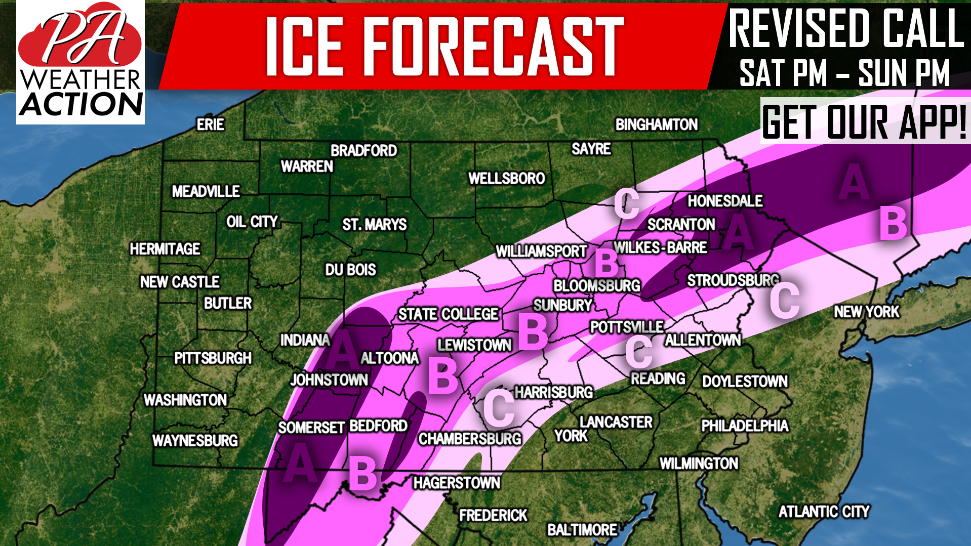
Area A: Ice accumulation of .25 – .50″ expected. Widespread power outages are possible, especially due to high winds partnered with this ice.
Area B: Ice accumulation of .10 – .25″ expected. Scattered power outages possible as a result of icy, and windy conditions.
Area C: Ice accumulation of .01 – .10″ expected. Isolated power outages possible as a result of icy, and windy conditions.
All ice will occur directly after the initial period of snow switches to freezing rain.
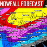
REVISED FINAL CALL SNOWFALL FORECAST

Area A: Snowfall accumulations of 12 – 18″ + expected. Travel will be near impossible early Saturday Evening into Sunday, and potentially beyond in more rural areas.
Area B: Snowfall accumulations of 8 – 12″ anticipated. Sleet and freezing rain may mix in, creating a layer of ice on top of the snow. Travel will be dangerous early Saturday Evening into Sunday.
Area C: Snowfall accumulations of 5 – 8″ expected. A period of sleet and freezing rain is likely, cutting down totals somewhat. Still, travel will be dangerous early Saturday Evening into Sunday.
Area D: Snowfall accumulations of 3 – 5″ anticipated, before turning to sleet and freezing rain, and then plain rain for a period. Travel will be hazardous early Saturday Evening into Sunday Morning.
Area E: Snowfall accumulations of 1 – 3″ expected, before turning to sleet and freezing rain, then rain.
Area F: Snowfall accumulations of < 1″ anticipated, before briefly turning to sleet and freezing rain, then rain.
Receive forecast updates throughout the storm with our free app >>> PA Weather App Link
We will be posting frequent updates on our facebook page. Be sure to like us if you haven’t already >>> PA Weather Action Facebook Page
Share this updated Final Call Forecast with friends and family using the button below, stay safe everyone!
You must be logged in to post a comment.