
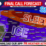
FINAL CALL Snowfall, Sleet, & Freezing Rain Forecast for Tonight – Friday Morning’s Winter Storm
Our Final Call Forecast has been posted, view the article above.
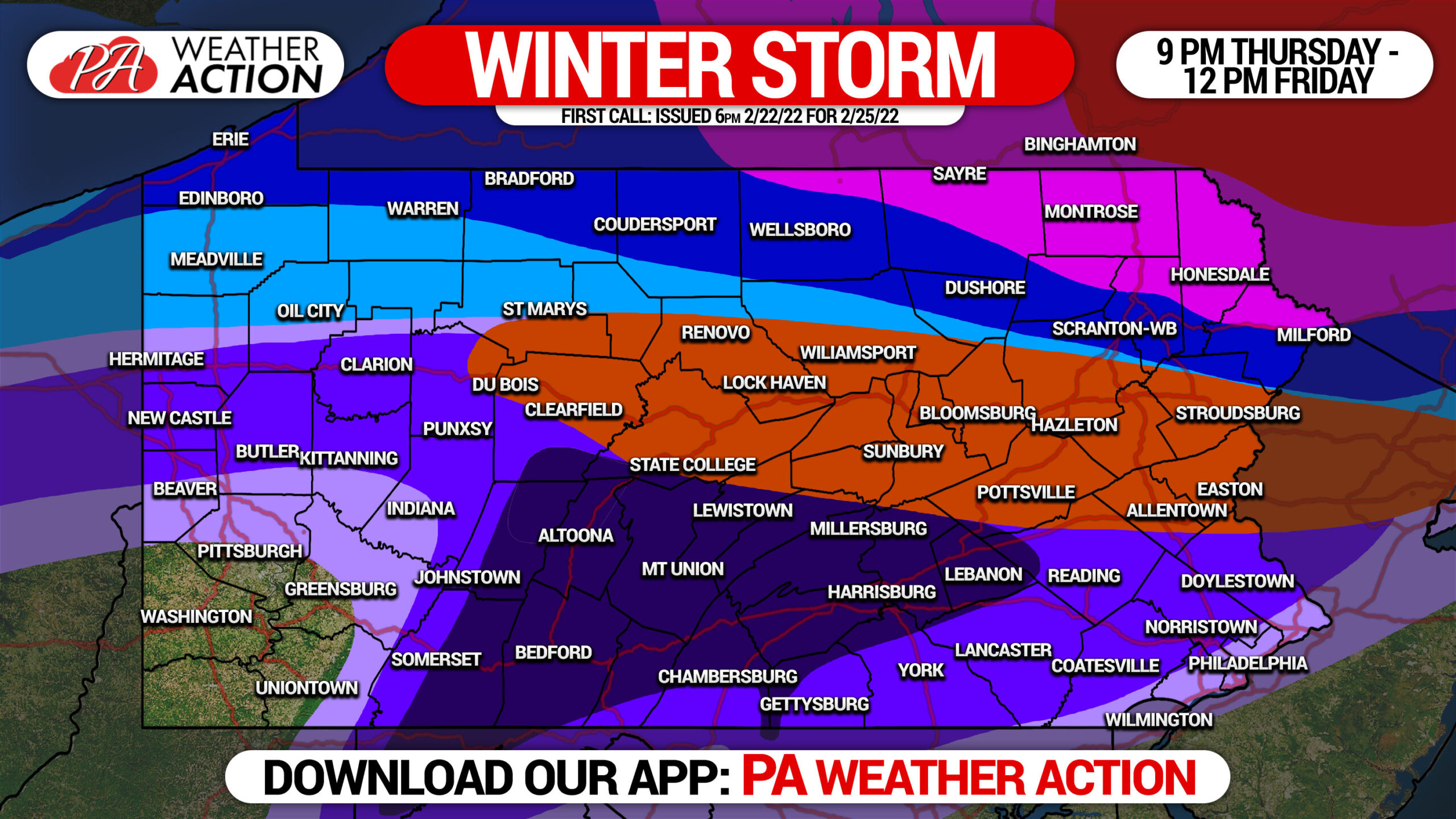
We have a serious mess on our hands with this storm, with significant amounts of snow, sleet, and freezing rain (ice) all likely. Exactly where the heaviest precipitation types occur all depends on the strength of high pressure to our north, where the primary low pressure tracks, and when it transfers to the coast. We also have to keep in mind that the ground is warm, so there will be differing impacts on paved surfaces versus elevated surfaces like trees and power lines.
Precipitation will move in from southwest to northeast late Thursday evening. As precipitation gets heavier early Friday morning, we expect to see power outages mount across parts of Central and Eastern PA. In addition, sleet and snow will begin to cover roads before sunrise on Friday near and north of I-80. A brief warm front will move across the state late Friday morning, causing temperatures to rise above freezing for a few hours. Monitor the temperature in your area during that time to determine when melting is occurring. Conditions should begin to improve from there, before temperatures fall back below freezing late Friday afternoon and evening.
Below is FutureCast Radar for the duration of this storm.
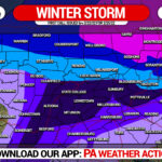
SECOND CALL SNOWFALL FORECAST FOR THURSDAY NIGHT – FRIDAY
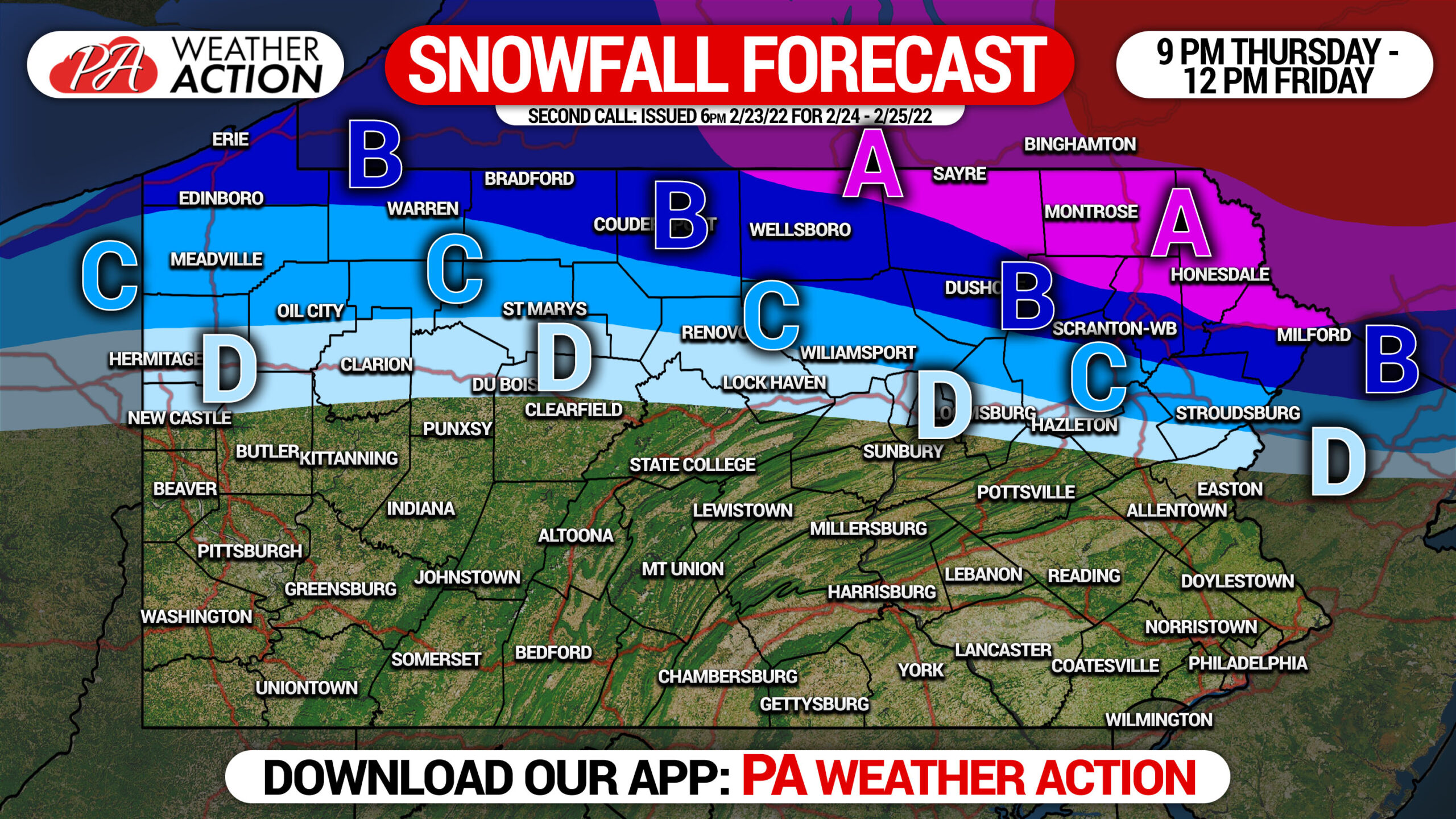
Paved surfaces will be warmer than non-paved and elevated surfaces. Therefore, expect accumulations to be depend on type of surface. The accumulations stated below are maximum accumulations on any surface.
Area A: Snowfall accumulation of 5 – 7″ expected.
Area B: Snowfall accumulation of 3 – 5″ expected.
Area C: Snowfall accumulation of 2 – 3″ expected.
Area D: Snowfall accumulation of 1 – 2″ expected.
SECOND CALL SLEET FORECAST FOR THURSDAY NIGHT – FRIDAY

Area A: Sleet accumulation of 1.0 – 1.5″ expected.
Area B: Sleet accumulation of 0.5 – 1.0″ expected.
Area C: Sleet accumulation of 0.1 – 0.5″ expected.
SECOND CALL ICE (FREEZING RAIN) FORECAST FOR THURSDAY NIGHT – FRIDAY
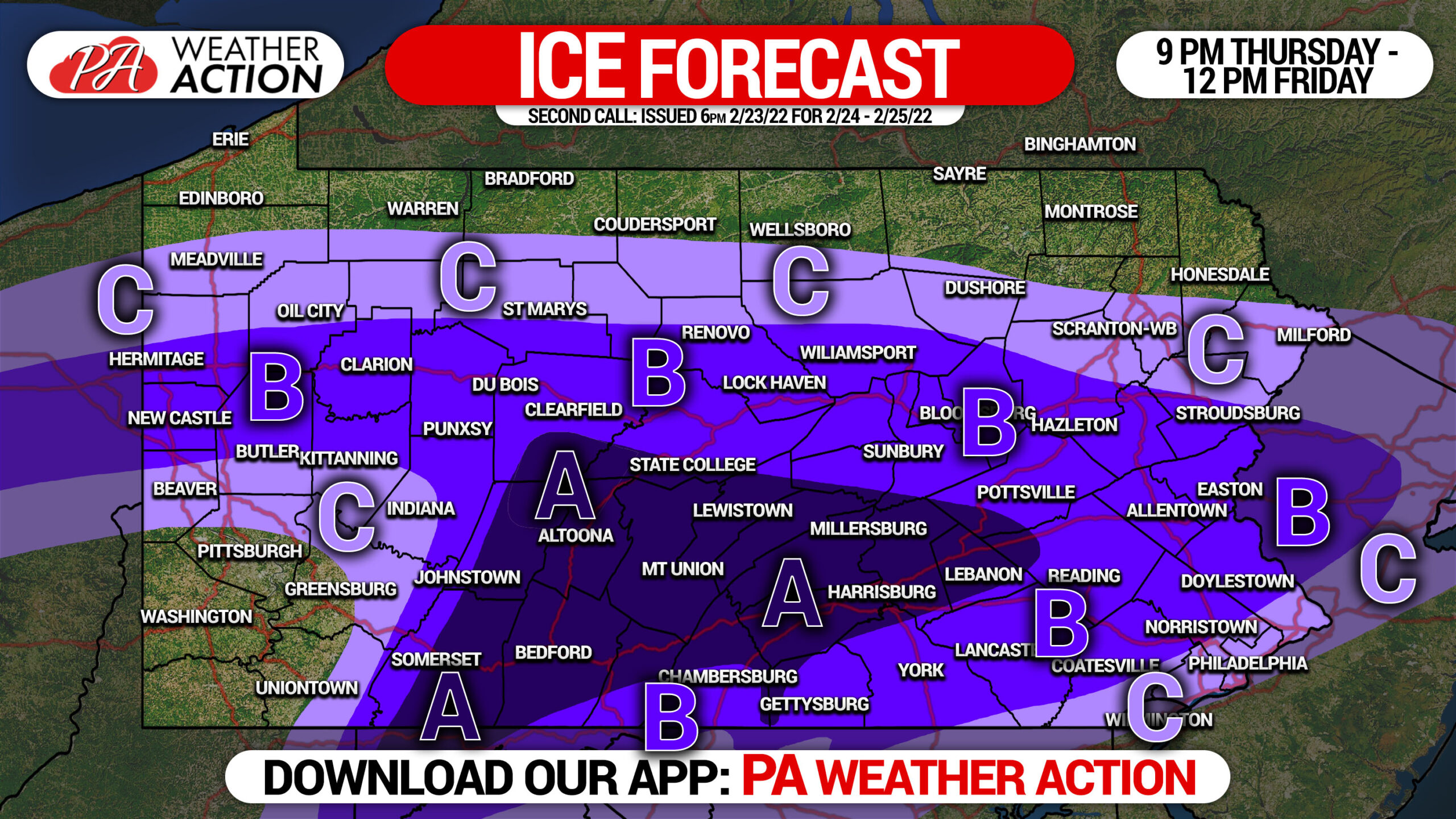
Paved surfaces will be warmer than non-paved and elevated surfaces. Therefore, expect accumulations to be depend on type of surface. The accumulations stated below are maximum accumulations on any surface.
Area A: Ice accumulation of .25 – .50″ expected. Widespread power outages possible.
Area B: Ice accumulation of .10 – .25″ expected. Scattered power outages possible.
Area C: Ice accumulation of .01 – .10″ expected.
Our final call forecast will be posted early Thursday Evening. Stay tuned to our facebook page for that, or you can be notified by our app.
Be sure to share this important forecast with family and friends. Do not downplay the ice!
[social_warfare]
Get latest forecasts, maps with road conditions, alerts and more in our Apple & Android app. Just tap the image below.
You must be logged in to post a comment.