
FINAL CALL FORECAST POSTED – TUESDAY PM UPDATE:
Final Call Snowfall Forecast for Wednesday’s Historic Winter Storm
A major to historic December snowstorm is less than 48 hours from arrival. Widespread amounts over a foot of snow is likely, with up to 20 inches of snow possible for a large stretch of the state. The National Weather Service has placed many counties under a Winter Storm Watch beginning this Wednesday and lasting through Thursday morning. We highly recommend if you have any traveling to do Wednesday, do it during the morning hours. By the afternoon, steady to heavy snow will quickly develop throughout the coverage area, making any traveling extremely treacherous.
TIMING:
Snow will develop from south to north during the day Wednesday. Southern Pennsylvania will see snow by the late morning hours, while northern locations will not see snow until the early afternoon on Wednesday. Below is a look at the Hi-Res NAM model valid for 1:00 PM Wednesday:
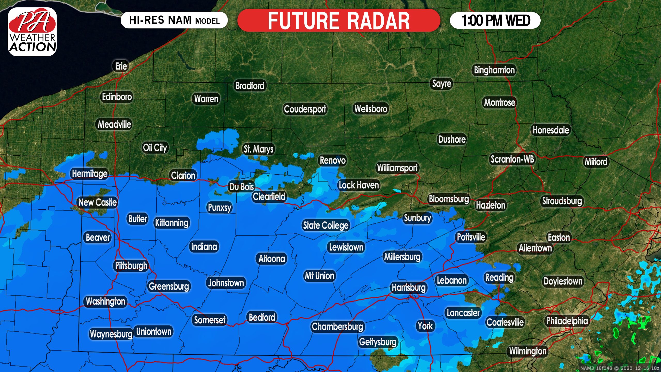
By the Wednesday evening rush hour, almost the entire state will be under at least some form of snow. The heaviest of the snow will fall between 4:00 PM Wednesday and 1:00 AM Thursday morning in southern and eastern PA. Again, it is highly recommended to avoid traveling during this time. Snowfall rates of 1 to 2 inches or more are expected. Below is a look at 7:00 PM Wednesday evening:

During the evening hours, the coastal low pressure will strengthen off the Del-Mar-VA coast. This will allow for intense banding to set up, especially across eastern Pennsylvania. Depending on how close the low pressure gets to the coastline, will determine if far southeast Pennsylvania mixes with sleet. This is still currently up in the air and is why we have these locations in lower snowfall totals. With that said, the latest Hi-Res NAM model keeps these areas all snow. Below is at 1:00 AM Thursday:
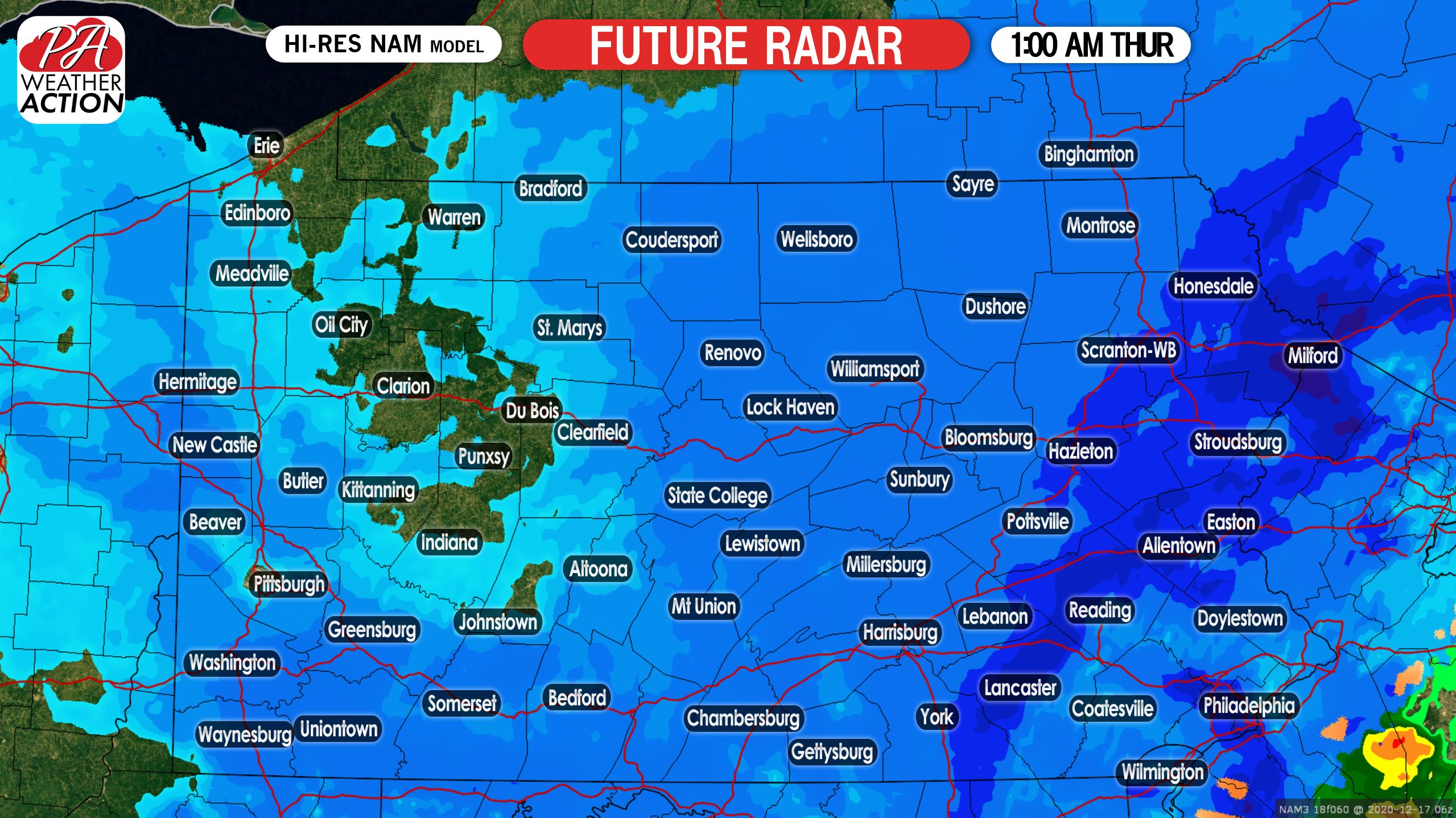
By 7:00 AM Thursday, the storm will be just about completely wrapped up with the exception being eastern Pennsylvania, where lingering snow showers are expected. By this time, many of us will be digging out from a double digit snowfall:

SECOND CALL FOR WEDNESDAY PM – THURSDAY AM MAJOR SNOWSTORM
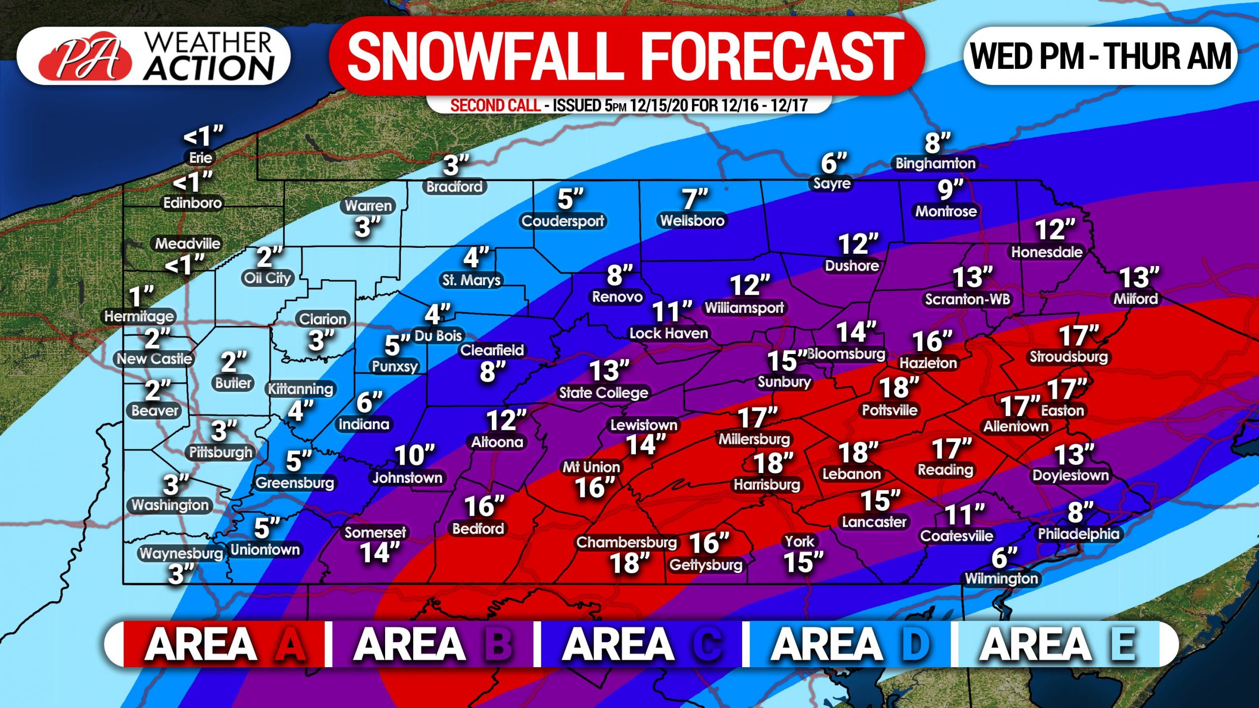
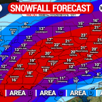
Area A: Snowfall accumulation of 15 – 20″+ is anticipated. Snowfall rates of 1/2″ to as high as 3″ per hour are expected across an 18 hour period, starting Wednesday afternoon through Thursday morning. Travel will be nearly impossible during and just after the storm. Scattered power outages will be possible.
Area B: Snowfall accumulation of 10 – 15″ is expected. Snowfall rates of 1/2″ to as high as 2″ per hour are anticipated over a 15 hour period, from Wednesday afternoon through early Thursday morning. Travel will be very difficult to impossible during and just after the storm. Isolated power outages will be possible.
Area C: Snowfall accumulation of 6 – 10″ is anticipated. Snowfall rates of 1/2″ to as high as 1″ per hour are likely across a 15 hour period, starting Wednesday afternoon through early Thursday morning. Locations on the southern edge of this zone will likely mix with rain and sleet. Travel will be difficult during and just after the storm.
Area D: Snowfall accumulation of 3 – 6″ is expected. Light to moderate snow is expected over a 12 hour period from Wednesday afternoon into early Thursday morning.
Area E: Snowfall accumulation of 1 – 3″ is anticipated. Light snow over a 9 hour period from Wednesday afternoon through the late evening is probable.
Our Final Call Snowfall Forecast will be posted Tuesday evening. For that and much more, get our new Apple & Android app here! >>> Weather Action App Link
This storm will bring severe impacts, and now is the time to prepare. Get the word out to your family and friends so they can plan accordingly, using the blue button below.
You must be logged in to post a comment.