
This week has been a roller coaster ride of expectations for tonight’s snowfall. Early in the week it appeared a significant snowstorm was possible, but that idea was quickly erased by Tuesday afternoon. Now, final trends before the storm suggest we will see a light to moderate snowstorm. Impacts will heavily vary across the state as usual. One thing we will all have in common is shoveling some powdery snow off the driveway Friday morning.
TIMING
SOUTHWEST PA: Light snow will move in around 6 – 8 PM, with localized moderate snow in Fayette and Somerset County. Heaviest snow amounts will be in those two counties. Snowfall rates of an inch an hour are likely in those areas, and a quarter to a half inch an hour elsewhere south of Butler and Punxsutawney. End time in SWPA is around 12 – 3 AM Friday.
CENTRAL PA: Light snow will rapidly push east-northeast into Central Pennsylvania, where light to moderate snow is expected to begin around 8 – 10 PM Thursday from west to east. Pockets of moderate snow are anticipated south of the turnpike, with snowfall rates of an inch an hour likely in those locations between 1 – 3 AM. Snowfall rates will be around a half inch an hour north of the turnpike. End time in SCPA is 4 – 6 AM Friday.
EASTERN PA: Light snow will enter Eastern Pennsylvania, mainly south of Scranton, around 11 PM Thursday – 1 AM Friday. Snowfall rates of 1″ an hour are expected south of Allentown between 4 – 6 AM, with rates of up to a half inch per hour north. Snow will then exit from west to east around 6 – 8 AM Friday.
HRRR MODEL FUTURE RADAR
FINAL CALL SNOWFALL FORECAST FOR THURSDAY EVENING INTO FRIDAY MORNING
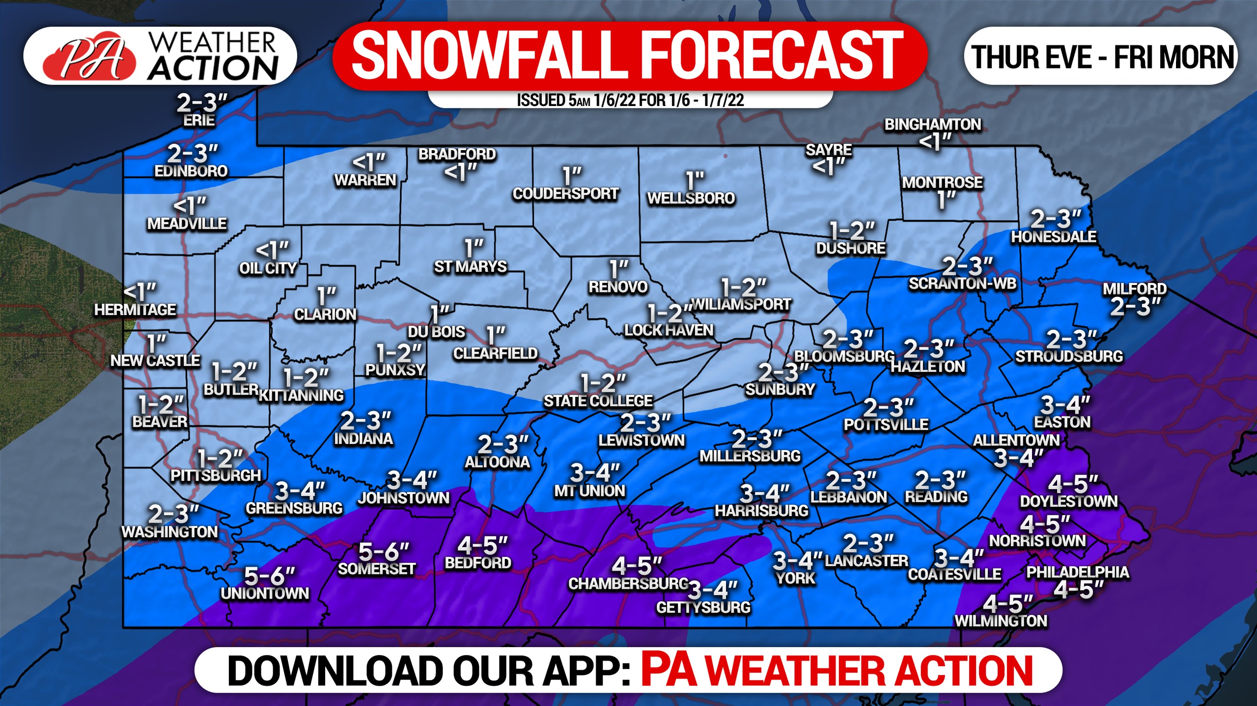
Purple Area: Snowfall accumulation of 4 – 6″ expected. View map for local amounts.
Dark Blue Area: Snowfall accumulation of 2 – 4″ anticipated. See map for local amounts.
Light Blue Area: Snowfall accumulation of 1 – 2″ expected. View map for local amounts.
Leave yourself extra time to clean the snow off your driveway and car in the morning, this will be fluffy snow and will easily move. School delays are likely in much of the area.
Don’t forget to share this new forecast with family and friends, especially those snow lovers out there.
[social_warfare]
Get localized snow timing in our app and interactive radar with nearly a dozen premium layers that we give you for free! Also get notified when we issue a new forecast. Just tap the banner below to download our app!
You must be logged in to post a comment.