
Another “surprise” round of snowfall is expected this afternoon and evening for much of Eastern Pennsylvania. Although we are not talking huge amounts, this will be the third accumulating snowfall for these areas this past week. For Western Pennsylvania, a separate clipper system will be bringing snow showers and heavy lake effect snow squalls tonight into tomorrow. But first, we are going to discuss the coastal system that will deliver a light snowfall for Eastern Pennsylvania.
A weak coastal storm that was expected to stay far enough offshore to leave our area dry, has trended far enough northwest to brush our area with snow later today. Snow will begin to fall over South-Central Pennsylvania around lunchtime. Below is the latest future radar valid 1:00 PM this afternoon: 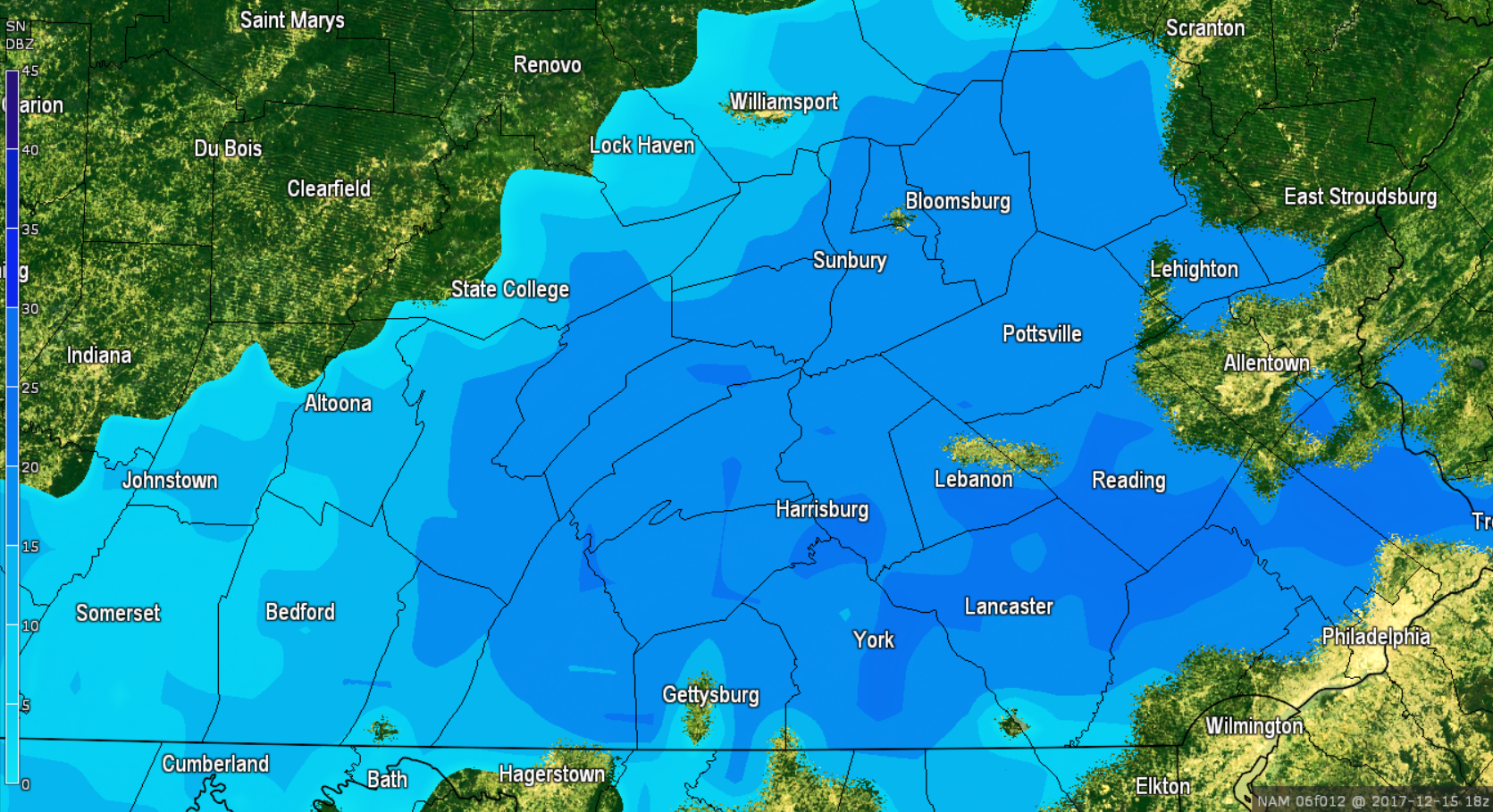
Although this is a quick hit of snow, there will be a several hour period of light to moderate snow over most of Eastern Pennsylvania. As the coastal storm gains some strength, the snow overspreads much of Eastern Pennsylvania by 4:00 PM: 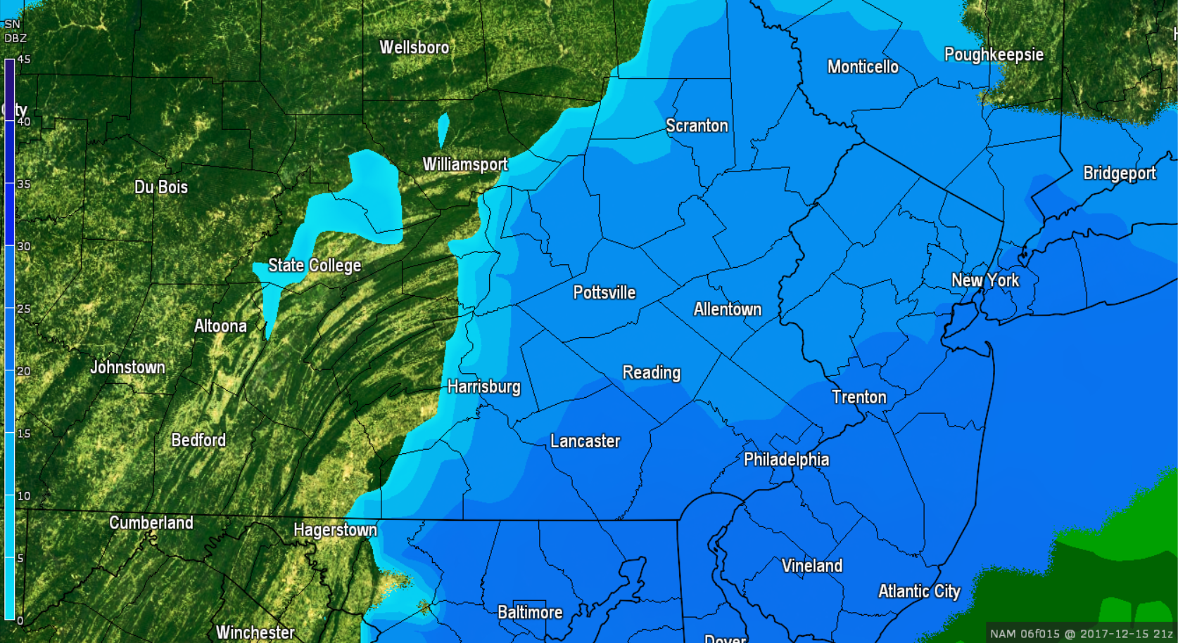
As quickly as the snow develops, the snow will be exiting the region. Notice the back edge is already riding the Susquehanna River. Timing is a concern however. The bulk of the snow, especially for far eastern areas, does appear to fall around the evening rush hour. If you have plans traveling this afternoon and evening, plan accordingly. The snow will begin to exit the region by 7:00 PM.
As the coastal storm exits, a clipper system will be providing snow showers and squalls to Western Pennsylvania this evening. Below is the future radar showing these snow showers and squalls arriving by 7:00 PM: 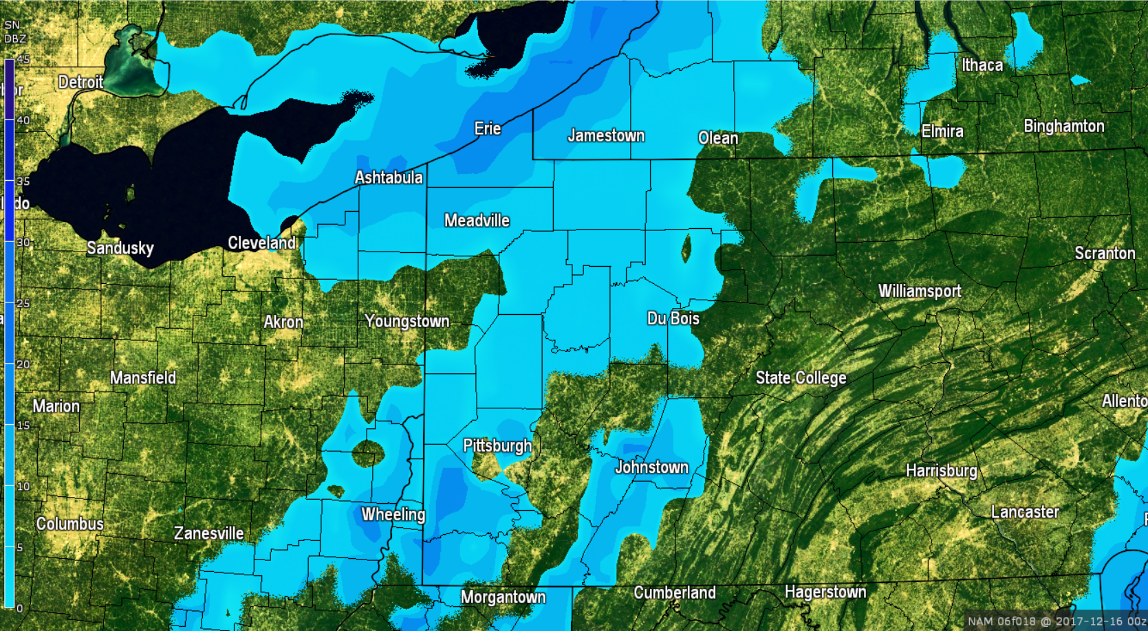
Most of Western Pennsylvania will see light accumulations, with the exception being for places closest to Lake Erie. Lake effect snow will once again be a major factor tomorrow. By 10:00 AM tomorrow, lake effect snow is in full blast for Northwest Pennsylvania: 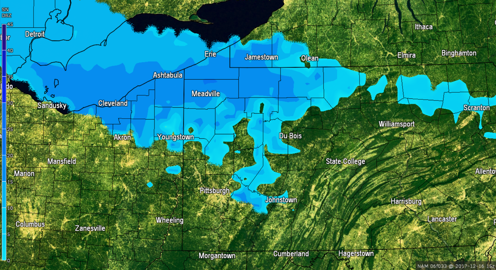
The snowfall for Northwest Pennsylvania will taper off by Saturday evening.
SNOWFALL FORECAST AMOUNTS EXPECTED THROUGH SATURDAY
NIGHT:
Timing for Eastern Pennsylvania: Snow will arrive between 11:00 AM and 1:00 PM this afternoon and will taper off between 5:00 PM and 8:00 PM this evening.
Timing for Western Pennsylvania: Snow will begin falling between 6:00 PM this evening and will be on and off throughout the day Saturday. Steadiest snows will be over Northwest Pennsylvania. 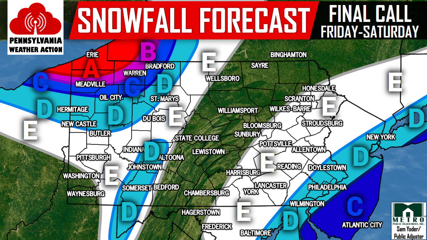
AREA A: 6 to 8 inches of snowfall is expected to fall beginning tonight and continuing throughout the day tomorrow.
AREA B: 4 to 6 inches of snowfall is expected to fall between tonight and continuing throughout the day tomorrow.
AREA C (Northwest PA): 2 to 4 inches of snowfall is expected to fall between tonight and continuing throughout the day tomorrow.
AREA C (Coastal areas): 2 to 4 inches of snowfall is expected to fall beginning early this afternoon and throughout this evening. Evening rush hour will be impacted with snow covered roads. Plan accordingly.
AREA D (Northwest PA + Laurel Highlands): 1 to 2 inches of snowfall is expected to fall beginning tonight and will continue throughout the day tomorrow.
AREA D (Southeast PA): 1 to 2 inches of snowfall is expected to fall beginning early this afternoon and will continue through this evening. Evening rush hour could be impacted by snow covered roads, especially back roads. Plan accordingly.
AREA E (Western PA): A coating to an inch of snowfall is expected beginning tonight and will continue on and off throughout the day tomorrow.
AREA E (Eastern PA): A coating to an inch of snowfall is expected beginning early this afternoon and ending by this evening. Slick road conditions are possible throughout the afternoon and into the evening rush hour.
Make sure you have our Facebook page liked to stay ahead of the latest weather, click here>>>Pennsylvania Weather Action’s Facebook Page
Download our app today for weather at your finger tips>>>Click here to download our app!
Be sure to share the snowy news with your family and friends below by using our icon below!
You must be logged in to post a comment.