
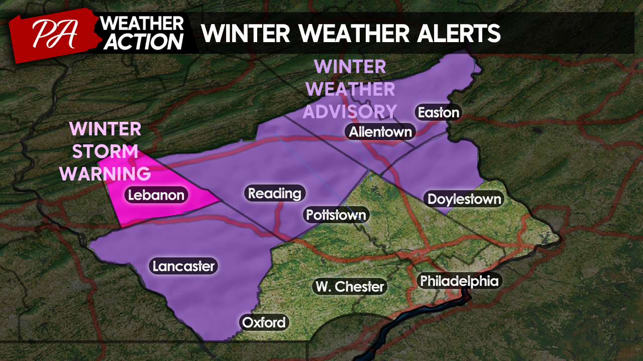
Good Evening Everyone! We are now less than 24 hours out from our winter storm, and our storm system is currently advecting across the Southern US. Besides a faster arrival and finish of our storm, not much has changed in our forecast regarding expected precip types and amounts. With this, the National Weather Service has issued Winter Weather Advisories for Lancaster, Berks, Lehigh, Northern Bucks, and Northhampton counties and a Winter Storm Warning for Lebanon County.
 Timing
Clouds will overspread the region by Saturday morning. Expect overcast skies and temperatures in the mid-upper 20s to start your Saturday morning. Snow will move into portions of Lancaster and Chester counties around 10 am, overspreading the entire region by the early afternoon.
Through the afternoon, snow will gradually mix with sleet and rain as easterly winds will draw in warmer air off the ocean. Areas further southeast in the region will see a changeover first. I expect areas along I-95 to see a changeover in the early afternoon, shortly after precipitation begins, greatly limiting accumulation in this region. Moderate – Heavy snow should continue elsewhere for the time being with models suggesting 1-2″ per hour snowfall rates likely.
By the mid-afternoon, the mixing line will push inland toward the I-76 corridor. I expect snow to transition to mixed precip across Lancaster, Chester, Montgomery, southern Berks, and Bucks counties between 3 – 7 pm (depending on location and elevation). Areas along i-95 will transition over to plain rain at this time. Moderate-Heavy snow will continue for regions to the north.
By the late evening, mixed precipitation will have filtered in across most of the region, even into portions of the Lehigh Valley. Mixed precipitation will move into Lebanon, Northern Berks, Lehigh, and Northampton counties between 8 pm-12 am. Areas south of here will transition to rain during this time.
Only the highest elevations of Lebanon, Lehigh, and Northampton counties are likely to hold onto all snow throughout the duration of this event, leading to the highest accumulations across these areas.
Here is the timing of precip types for a few major cities in our region.
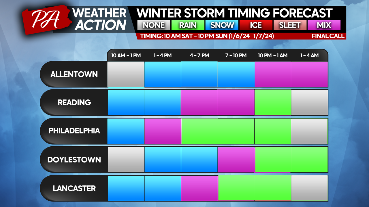
Precip will begin to exit the region from southwest to northeast between 10 pm – 3 am Saturday night. In the previous blog, I mentioned the possibility of a changeover back to snow for areas that mix. That now seems unlikely, as the quick motion of this storm will bring an end to precipitation before cold air filters back in, aside from a few snow showers possible Sunday morning across our northern counties.
Snowfall Totals
Here is a look at the projected totals:
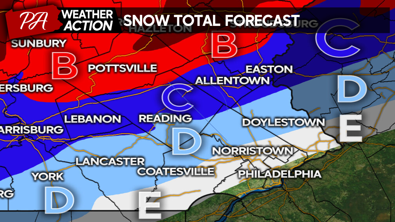 Zone B: Snow accumulation 6 – 8″ expected. All Snow. Expect accumulation on grass and roadways, leading to very difficult driving conditions. Includes higher elevations of Northampton, Lehigh, Berks, and Lebanon counties.
Zone C: Snow accumulations 4 – 6″ expected. Snow to Wintry Mix. Expect accumulation on grass and roadway, leading to very difficult driving conditions. Includes i-78 corridor, Lebanon, much of Berks, Lehigh, Northampton, and far northern Bucks counties.
Zone D: Snow accumulations 2 – 4″ expected. Snow to Wintry Mix to Rain. Expect accumulations mostly on grassy surfaces with a few slick spots, especially on bridges and overpasses. Includes most of Lancaster, Northern Chester, Northern Montgomery, and Northern Bucks counties.
Zone E: Snow accumulations T – 2″ expected. Brief Snow to Wintry Mix to Rain. Expect accumulations mostly on grassy surfaces. Including Southern Lancaster, Southern Chester, Northern Delaware, Northern Philadelphia, Southern Montgomery, and Southern Bucks counties.
South of Zone E, expect a brief wintry mix to rain with no accumulation expected.
Additionally, while the attention is currently on tomorrow’s storm, I am tracking a significant rain and wind storm coming midweek. Models suggest that the next storm is likely to be much more impactful than tomorrow’s sloppy winter storm, with the threat of both flooding and wind damage. I will provide a few updates on Facebook tomorrow as the storm evolves, and I will have another blog post out Monday evening detailing the impacts of our next storm.
Whether you are excited or dreading the upcoming winter weather, I hope you all have a great weekend!
-Michael Woytowiez.

You must be logged in to post a comment.