
Good Evening Everyone! Winter has made its return to Southeast PA for the time being. Aside from the snow, temperatures are much colder than they were last week.
This pattern lasts through the weekend, with another shot of light snow Friday Night through Saturday Morning. Temperatures will be plenty cold enough Friday night for this to be an all-snowfall event for the entire region.
A Winter Weather Advisory has been issued for Chester, Delaware, Philadelphia, Southern Montgomery, and Southern Bucks counties. I expect these watches to expand across the entire region before tomorrow night. Cold weather will also linger through the weekend.
Friday
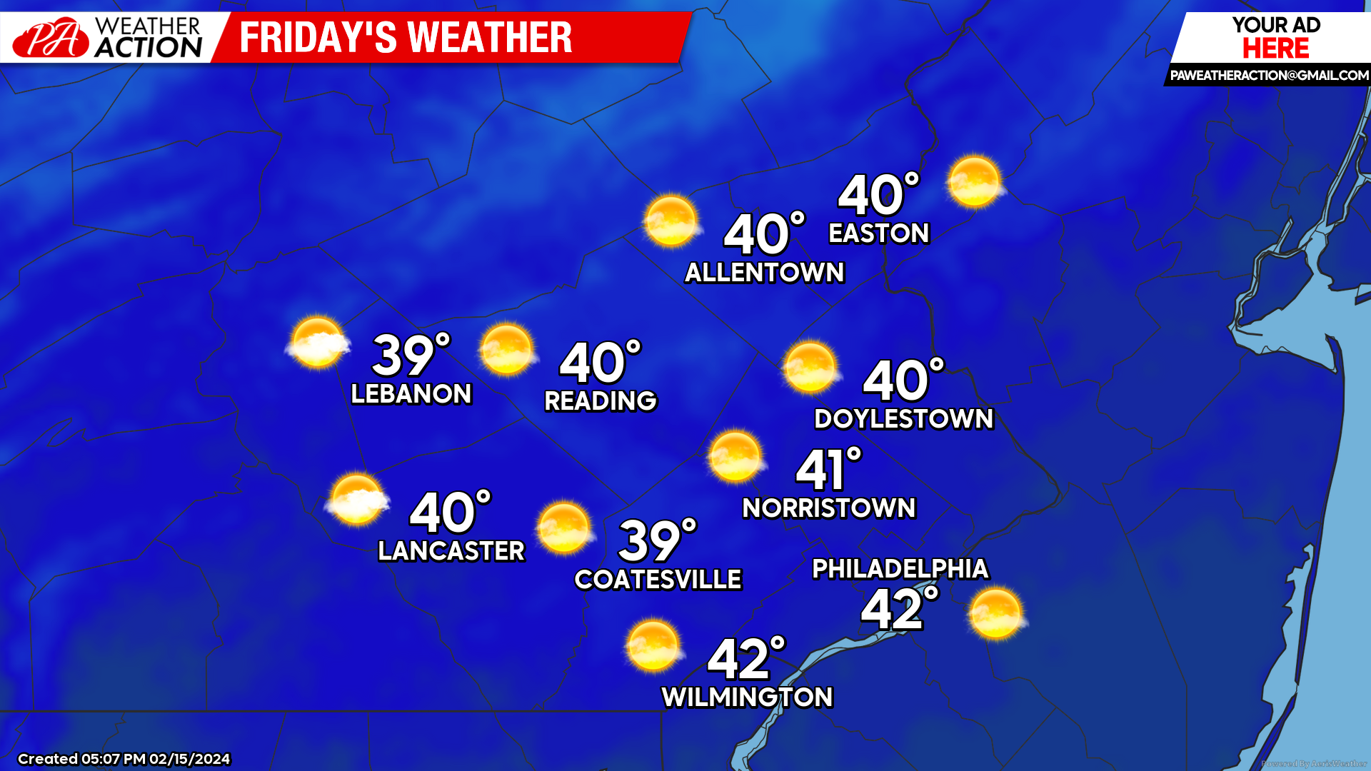
Before our snow arrives overnight, Friday should be a blustery, seasonable day. The passage of a cold front overnight will bring a chilly and blustery start to your morning. Temperatures will start in the upper 20s – low 30s across the region. However, wind gusts up to 25mph will result in wind chill values in the 10s and low 20s tomorrow morning.
Expect clear skies throughout most of the day with highs reaching the upper 30s – low 40s. Winds will remain blustery throughout the day at 10-20mph with gusts to 30mph. This will keep wind chills in the 20s and low 30s throughout the day.
Clouds will fill in Friday evening ahead of our snow event.
Friday Night Snow
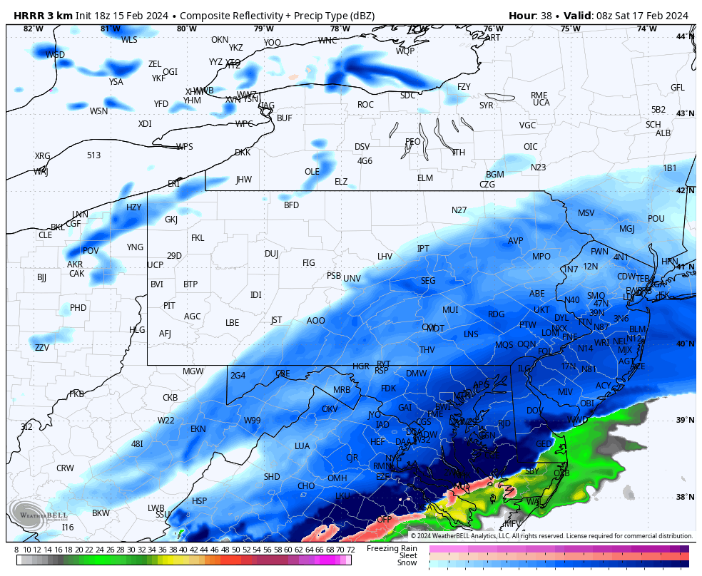
Snow will overspread the region between 8-10 pm Friday night. With light to moderate snowfall continuing through the overnight wrapping up between 5-8 am on Saturday. Snowfall rates of 0.5″ – 1.5″ are likely at times Friday night.
Temperatures will start in the low 30s at the onset of precipitation and will fall into the low-mid 20s throughout the event. This will ensure an all-snow event for the entire region.
The colder temps will also ensure lighter and fluffier snow compared to the heavy, wet snow we received earlier this week.
Plan on slick travel conditions Friday Night – Saturday Morning. It would be best to try and avoid the roadways while the snow is falling.
Here is the timing for snowfall for a few major cities in our region:

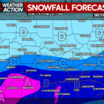
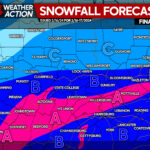
While this is a pure snow event, lighter snowfall rates and a quick-moving system will help us avoid the big totals. However, a decent accumulation is still expected across the region. A southern storm track will allow for the southern portion of the region to see the biggest totals. Snowfall rates will be highest here with bands of moderate snow possible at times.
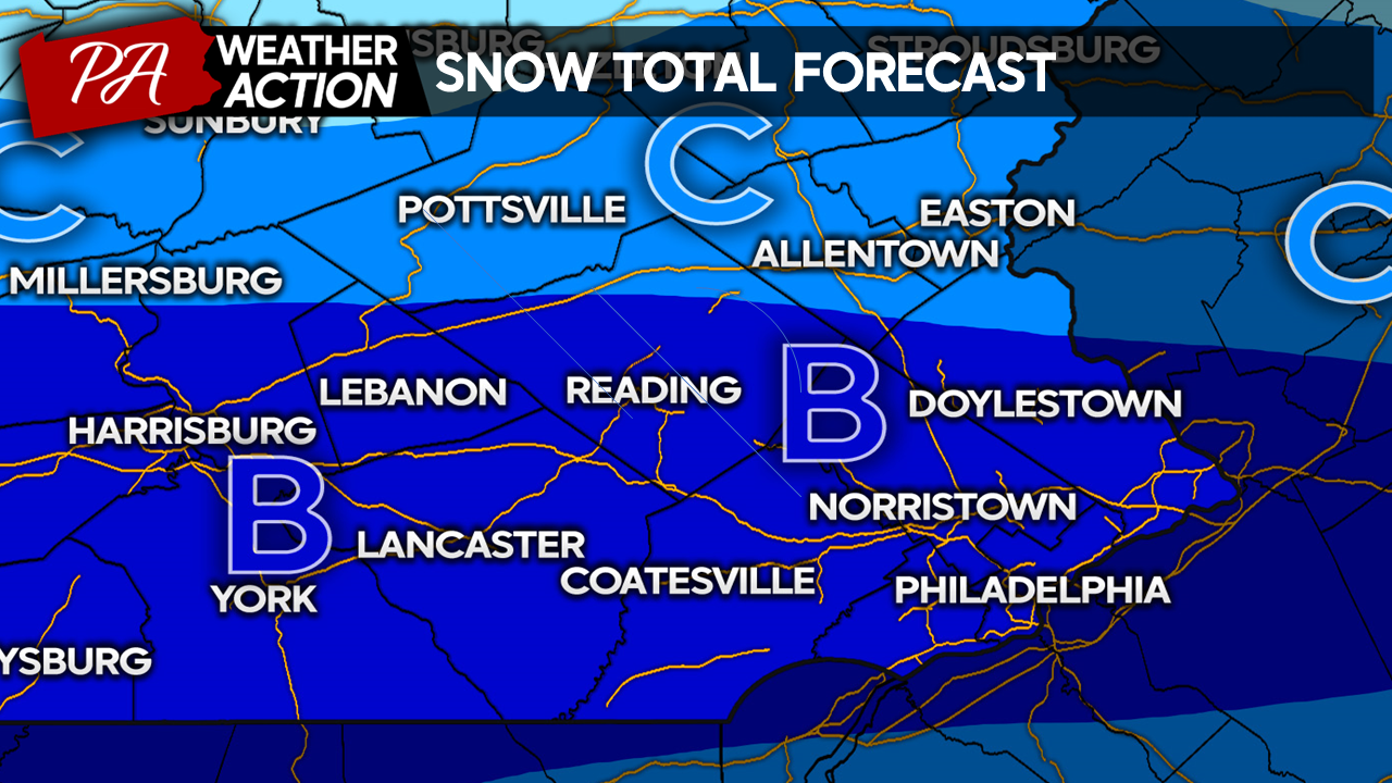
Zone B: 3″-5″ Snow. 0.5″ – 1.5″ per hour snowfall rates likely. Avoid travel during snowfall as conditions will be treacherous. Snow drifts are possible on rural roads.
Zone C: 2″-3″ Snow. 0.3″ – 0.6″ per hour snowfall rates likely. Difficult travel at times during snowfall.
Saturday
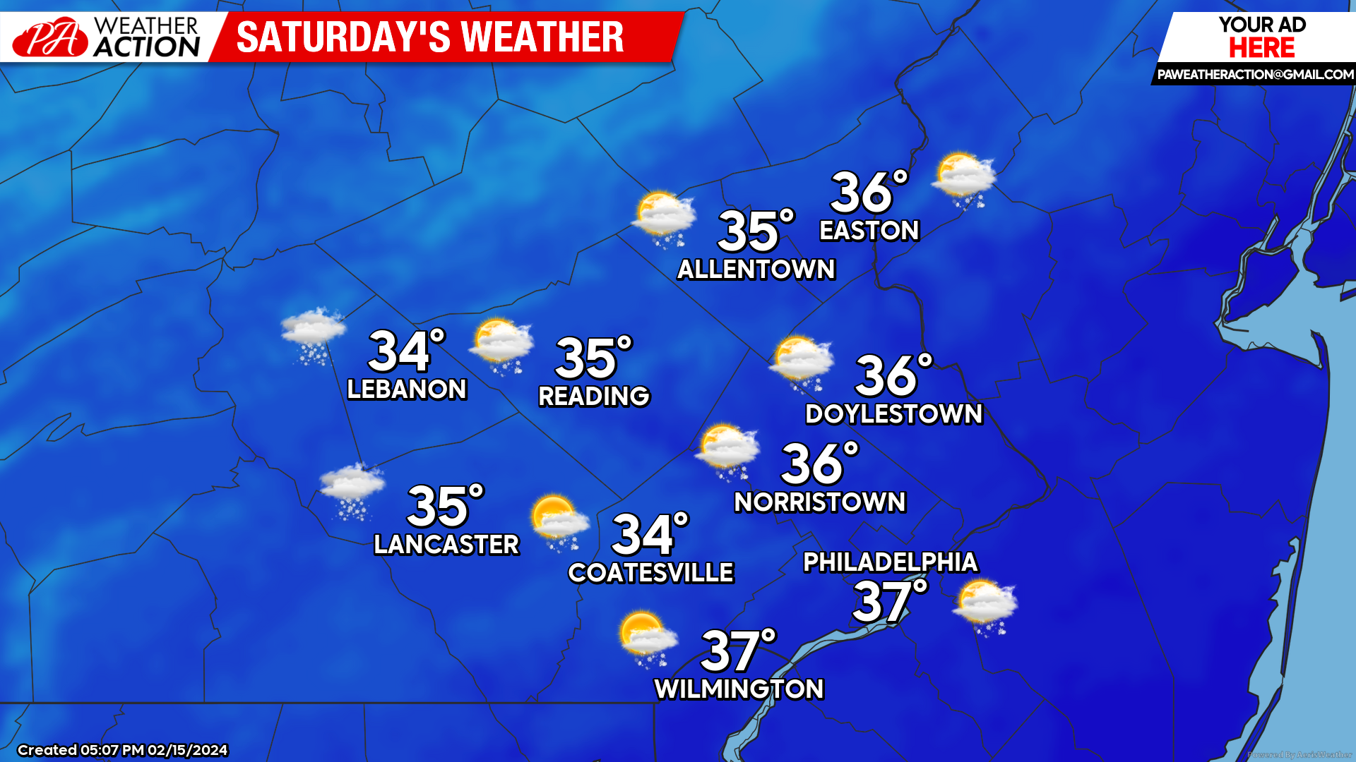
Saturday will feel like a true winter day across the region. Our snowfall will exit during the early morning hours, giving way to gradually clearing skies. Temperatures will start in the mid-20s across the region.
By lunchtime, skies will have cleared to partly cloudy conditions. Temperatures will rise into the mid-30s across the region. Winds will pick up throughout the morning out of the NW at 10-20mph with gusts to 30mph. This will keep wind chills in the low-mid 20s throughout the day. I am also concerned that blowing snow, which can briefly reduce visibilities, will be a threat throughout Saturday with the fluffier texture of snow and strong winds.
Skies will turn clear by the evening and through the overnight.
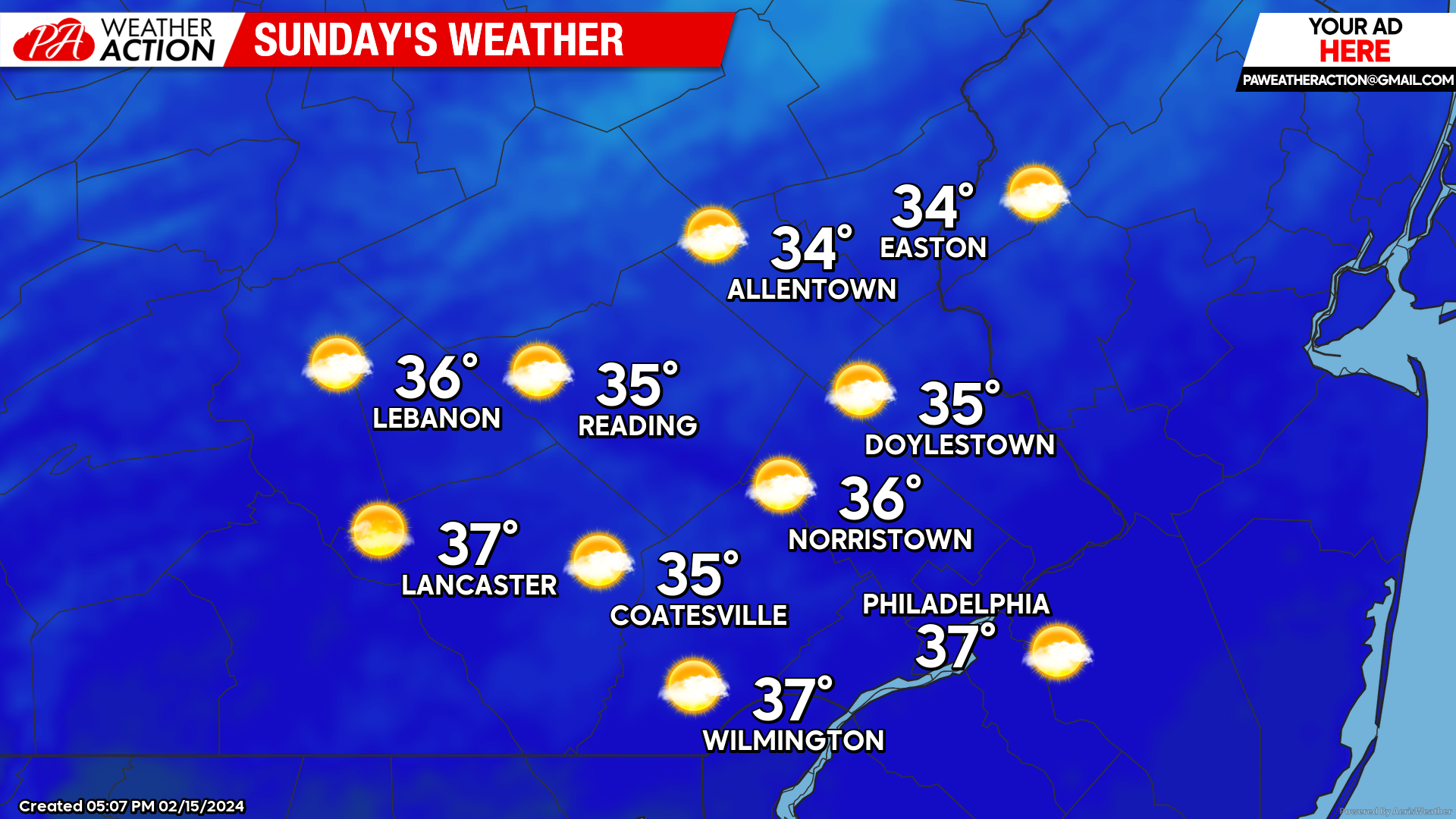
Sunday
Sunday will feel very similar to Saturday. Expect a clear and cold start to the day with temperatures in the low-mid 20s and wind chills in the low-mid 10s Sunday morning.
With mostly sunny skies, temperatures will top out in the mid-30s Sunday afternoon. Winds out of the North at 10-15mph with gusts to 30mph will keep wind chills in the 20s throughout the day.
Expect mostly clear skies to persist into the evening.
You must be logged in to post a comment.