
UPDATED FIRST CALL HAS BEEN RELEASED, CLICK HERE FOR THE LATEST>>>>https://paweatheraction.com/first-call-snowfall-forecast-for-saturday-monday-winter-weather-event
Our first widespread snow event of the season is likely Sunday into Monday across much of Pennsylvania. Models are beginning to align, raising our overall forecast confidence. There is the potential for significant snowfall in parts of the state.
Breakdown: A low pressure system will move through the Upper Great Lakes late this week. A cold front will be partnered with this system, sweeping through the region Saturday Evening into Sunday Morning. Precipitation will switch from rain to snow from west to east throughout Western and Central Pennsylvania. However, the majority of the anticipated snowfall will be lake effect as strong northwest winds blow heavy snow showers off Lake Erie.
Temperatures will drop 20-30 degrees Saturday Evening as a result of this cold front. Wind gusts over 30 MPH are also expected as the front passes through.
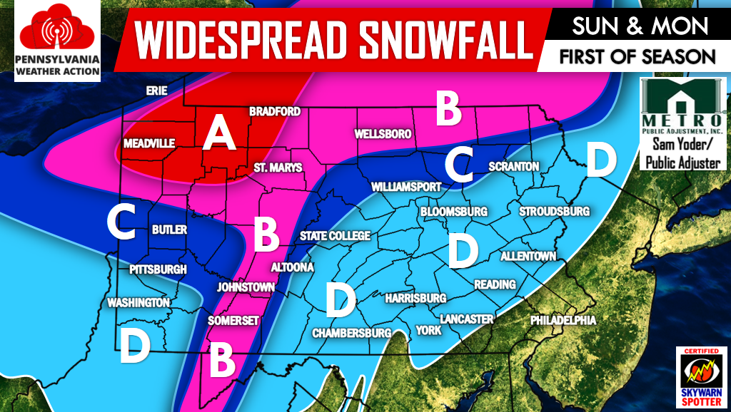
MAP FORECAST
Area A – Significant snowfall accumulation possible. Snow will begin Saturday Night, continuing through the day on Sunday, lasting all the way until Monday Evening. Areas in strongest and most persistent lake effect snow bands may experience near white-out conditions and 6-12″ of snow.
Area B – Moderate snowfall accumulation possible. Snow will begin Saturday Night, lasting into Sunday before ending Monday Morning. Areas in strongest and most persistent lake effect snow bands may experience near white-out conditions and 3-6″ of snow.
Area C – Light snowfall accumulation possible. Snow will begin Saturday Night into Sunday Morning. It will be off-and-on through the day Sunday before wrapping up Sunday Night. About 1-3″ of snow is possible.
Area D – Snow showers possible Saturday Night into Sunday Afternoon, wrapping up by evening. Flurries to a scattered coating is possible.
Be sure to like Pennsylvania Weather Action on Facebook by clicking here for the latest updates on this event and the many more to come. Also remember to share this forecast using the icons below the map! Stay safe!
You must be logged in to post a comment.