Skip to content
Facebook page opens in new windowTwitter page opens in new windowYouTube page opens in new window
PA Weather Action
Pennsylvania Weather Action, LLC
PA Weather ActionPA Weather Action
  • APP
  • WEATHER RADAR
  • SEVERE CENTER
  • AIR QUALITY
  • LONG RANGE
  • NRG PARTNERSHIP
  • CONTACT
Search:
  • APP
  • WEATHER RADAR
  • SEVERE CENTER
  • AIR QUALITY
  • LONG RANGE
  • NRG PARTNERSHIP
  • CONTACT

Yearly Archives: 2017

You are here:
  1. Home
  2. 2017

Trick-or-Treat Forecasts Out: Chilly Halloween Expected

Fall WeatherBy Lead Forecaster Josh AdamsOctober 24, 2017

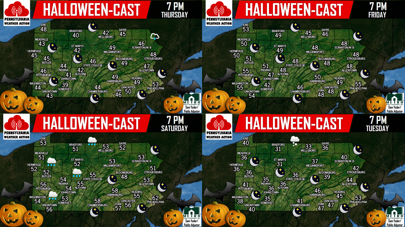
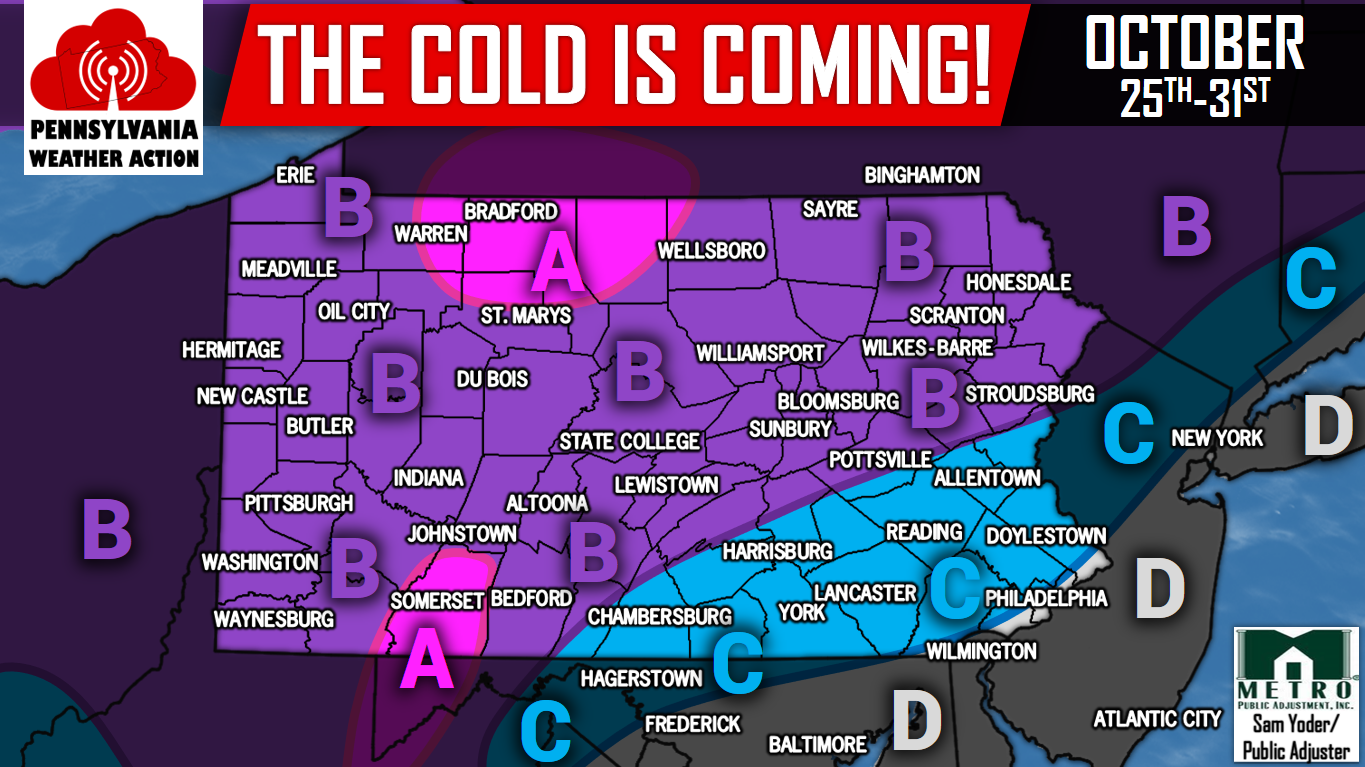
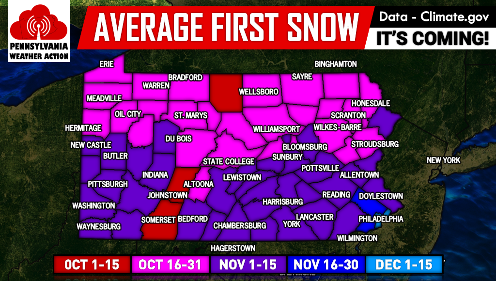
As advertised in previous forecasts, a chilly Halloween is anticipated this year with a few flurries possible in Northwest PA. Areas across the state are having their trick-or-treating on different days, so we covered all four of the most common days. Share the Halloween-Cast with your friends using the share button below!   THURSDAY OCTOBER…

Share166
166 Shares

Storms to Bring Gusts of 50 MPH Tonight, Tuesday Morning

Severe WeatherBy Lead Forecaster Josh AdamsOctober 23, 2017

What may be the final thunderstorms of 2017 will move through the state tonight. A line of storms will enter Western PA by mid-evening, moving east through the night. By Tuesday Morning, the line will reach Eastern PA. The Storm Prediction Center has placed much of Eastern PA under a Marginal and Slight Risk. The…

Share650
650 Shares

Heavy Rain, Strong Storms Expected Late Tonight into Tuesday

Severe WeatherBy Lead Forecaster Josh AdamsOctober 23, 2017

We are tracking a low pressure system that will be passing to our west today, leading to the potential of scattered showers throughout the daylight hours. As we head later into tonight, a cold front will be passing through the region leading to a period of heavy rain and strong winds. This line will move…

Share467
467 Shares

Coldest Halloween in Years With First Snow Possible

Fall Weather, Winter WeatherBy Lead Forecaster Josh AdamsOctober 21, 2017

An abrupt change of the seasons is about to occur as cold temperatures will soon come roaring in just in time for Halloween. Temperatures will not make it out of the 40s and 50s on Wednesday and Thursday, with lows in the 20s and 30s. There will then be a short warm up next Saturday…

Share10.07K
10.07K Shares

Cold Blast Coming Next Week, Chilly Halloween Expected

Fall WeatherBy Lead Forecaster Josh AdamsOctober 17, 2017

Before the coldest air of the season arrives next week, the remainder of this week will bring above average temperatures. For most of October, the east coast has been under a strong ridge, allowing for warmer than average temperatures. Below is the GEFS model valid for Friday of this week. High temperatures will be in…

Share2.58K
2.58K Shares

Widespread Frost & Freeze Expected Tonight Across PA

Winter WeatherBy Lead Forecaster Josh AdamsOctober 16, 2017

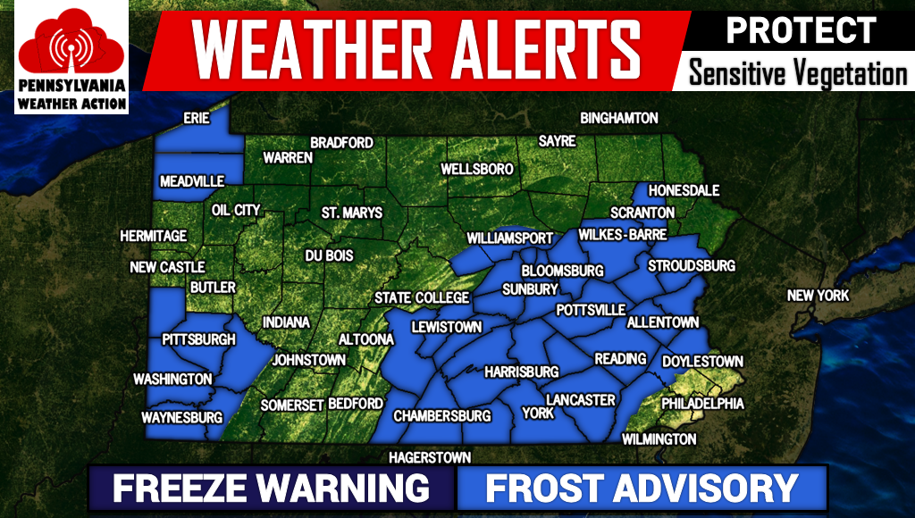
Temperatures will drop into the upper 20s and 30s tonight across the entire state. As a result, the National Weather Service has issued Frost Advisories across much of Southwest PA, Southcentral PA, and Eastern PA. Although locations in Northern PA and the Laurel Highlands are not included, near-freezing temperatures are still expected. Below are the…

Share523
523 Shares

Signs of First Flakes By Late October

Winter WeatherBy Lead Forecaster Josh AdamsOctober 12, 2017

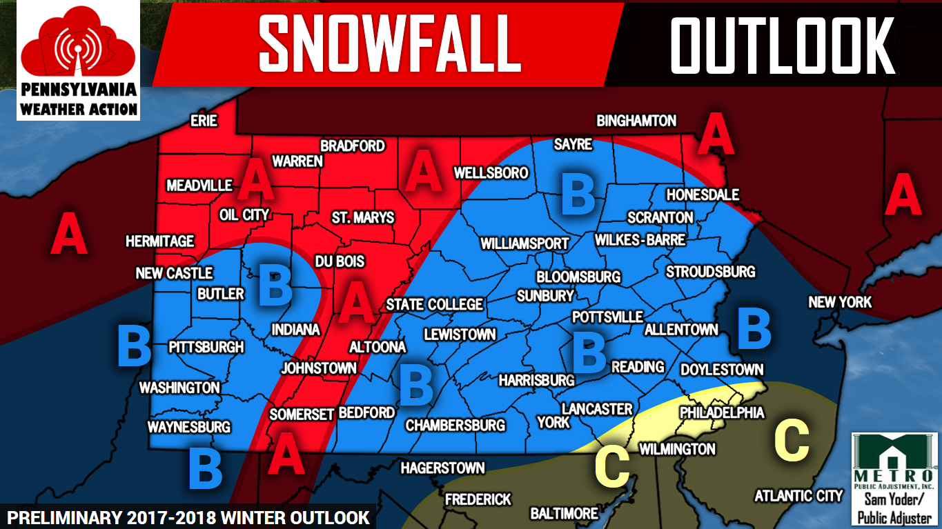
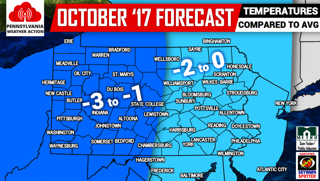
Yet another winter is right around the corner, as Christmas is just 73 days away. Our Preliminary 2017-2018 Winter Outlook was posted yesterday. If you missed it, click here! Believe it or not, many areas of Northern PA typically see their first snowflakes in Late October. Below is a map displaying average first flakes county-by-county.…

Share1.52K
1.52K Shares

Preliminary 2017-2018 Winter Outlook

Winter WeatherBy Lead Forecaster Josh AdamsOctober 11, 2017

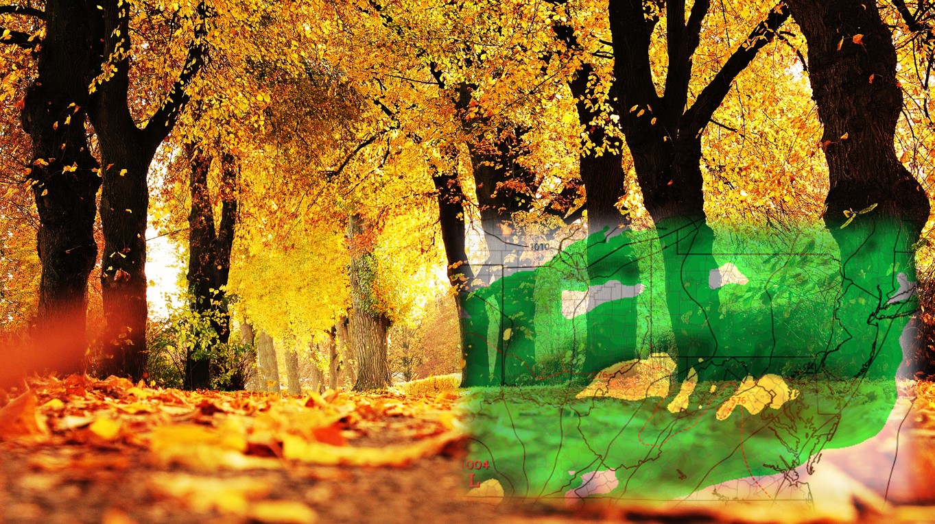
Meteorological winter begins in seven weeks. Yet in many areas, fall foliage color remains low. Will this warm and dry pattern continue into winter? We will do our best to answer that question in this year’s Preliminary Winter Outlook. Feel free to scroll to the bottom to view our snowfall and temperature outlooks. For those…

Share2.04K
2.04K Shares

Beneficial Rainfall Expected Sunday Afternoon – Monday Night

Autumn, Heavy RainBy Lead Forecaster Josh AdamsOctober 8, 2017

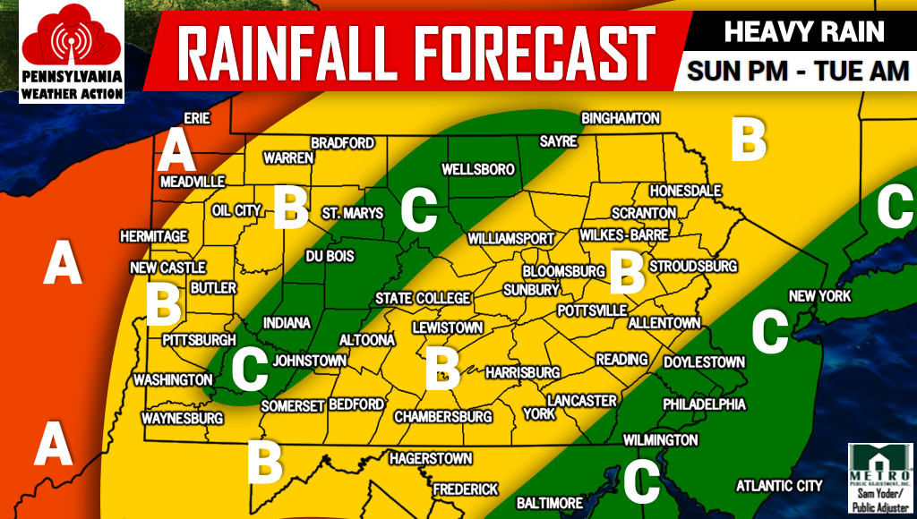
After three weeks of no rainfall, the remnants of Nate will bring Pennsylvania much needed precipitation. Showers from the storm have already begun to stream into the area. Heavier rainfall will come into the picture by Sunday Evening. Here is the Future Radar for 9 PM Sunday. By this time there will be some heavier…

Share454
454 Shares

Still Hope for Fall Foliage as Tropical Rainfall Possible Next Week

AutumnBy Lead Forecaster Josh AdamsOctober 4, 2017

A prolonged dry spell has significantly impacted fall foliage up to this point. For many areas in Pennsylvania, it has been three weeks since the last raindrop. This combined with the heat has slowed foliage change and resulted in many brown or even green leaves to fall. There is hope in sight, as a tropical…

Share103
103 Shares

First Frost & Freeze of Season Tonight; First Snowflakes Coming Soon

Autumn, Winter WeatherBy Lead Forecaster Josh AdamsSeptember 30, 2017

After a week of hot weather with temperatures in the 80s, suddenly we are looking at first frosts and freezes tonight. The National Weather Service has issued Frost Advisories for many areas north of I-80 with Freeze Warnings in the high mountains of Northcentral PA. Temperatures are expected to dip into the low to mid…

Share5.32K
5.32K Shares

Fall Weather Forecast: Roller Coaster Temperatures, Early Start to Winter

Long Range ForecastBy Lead Forecaster Josh AdamsSeptember 14, 2017

Believe it or not, the year 2017 is 70% over. The leaves are beginning to change, and by this time next month many areas of Pennsylvania will be peaking regarding fall foliage. The past two years featured hot summers and warm falls. So much so, most of us have not seen snow in December since…

Share1.49K
1.49K Shares

Scenarios for Hurricane Irma; Catastrophic Damage Inevitable

TropicsBy Lead Forecaster Josh AdamsSeptember 6, 2017

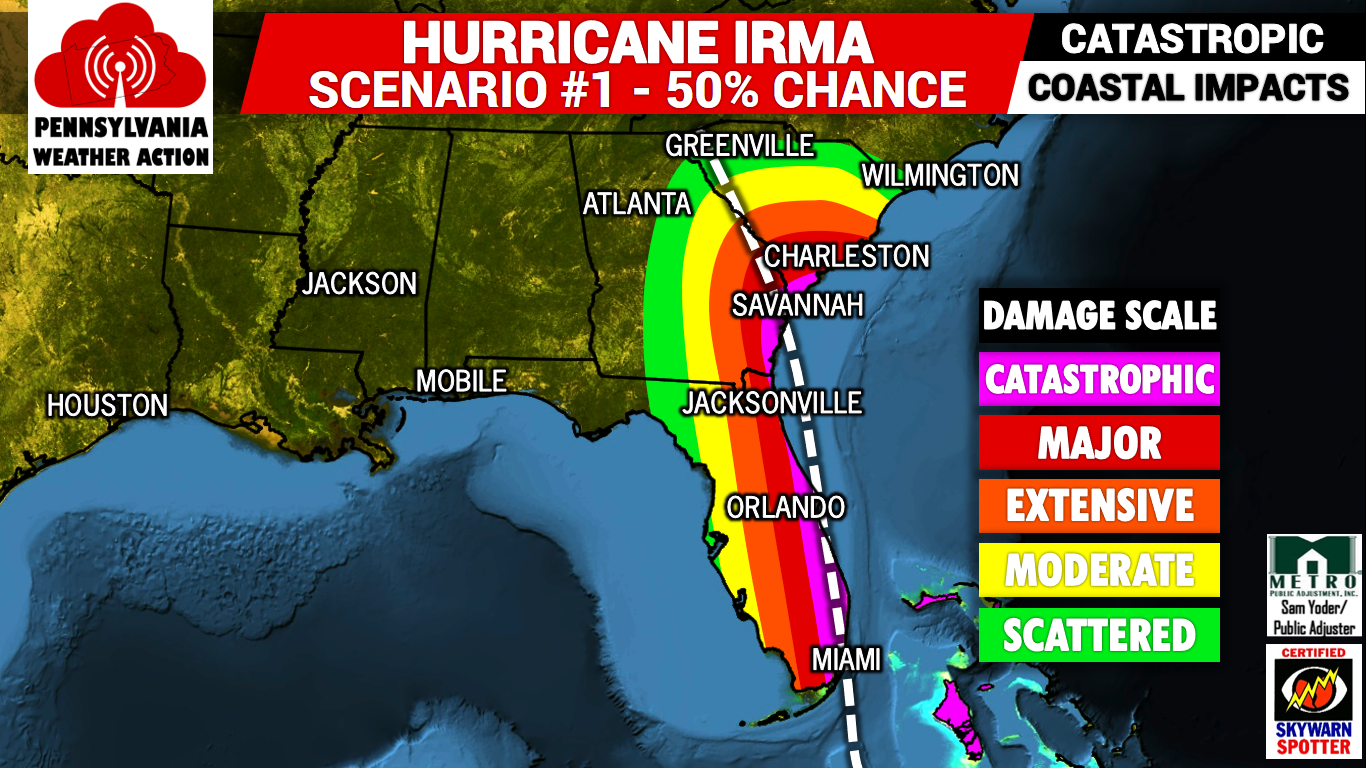
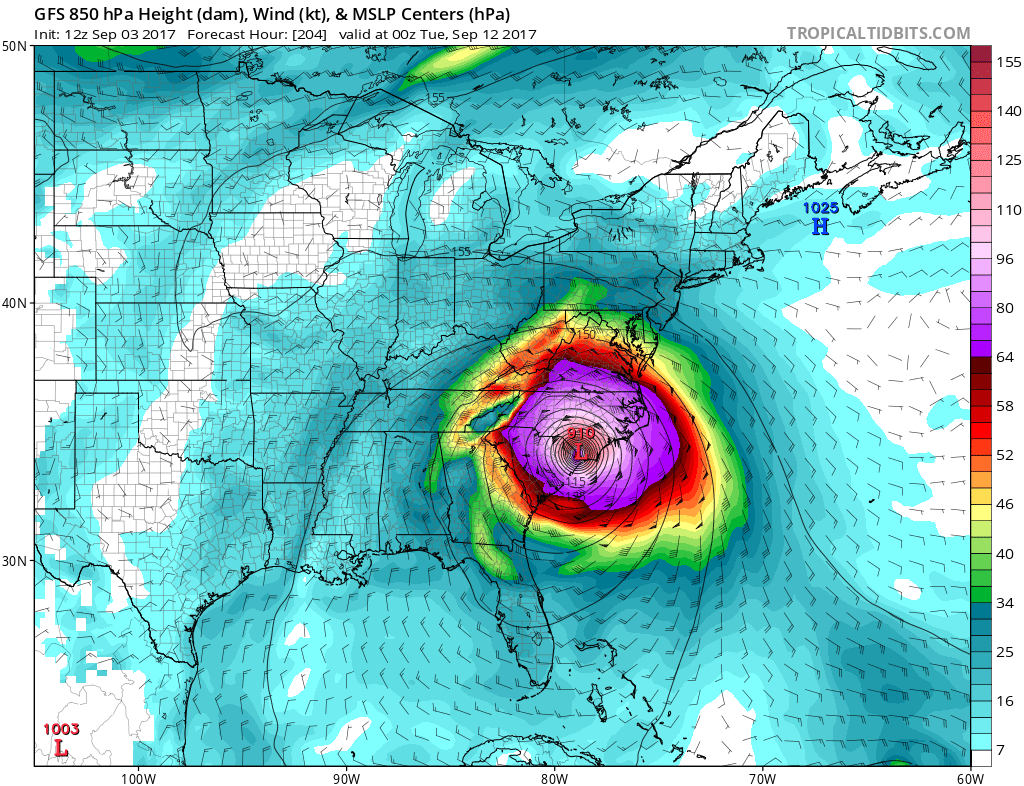
Unfortunately, a very serious and catastrophic situation is unfolding right in front of us as Hurricane Irma approaches closer and closer to the United States. Hurricane Irma is currently a category five. Only three hurricanes in United States history have made landfall as a category five in the United States. Irma has the potential to…

Share8.48K
8.48K Shares

RAW VIDEO: Possible Tornado, Power Flashes in West York, PA

Severe WeatherBy Lead Forecaster Josh AdamsSeptember 5, 2017

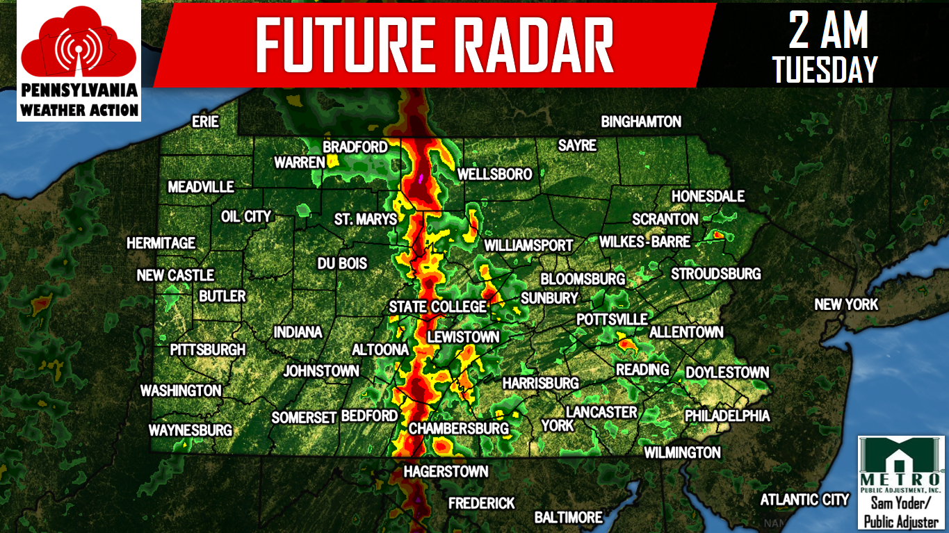
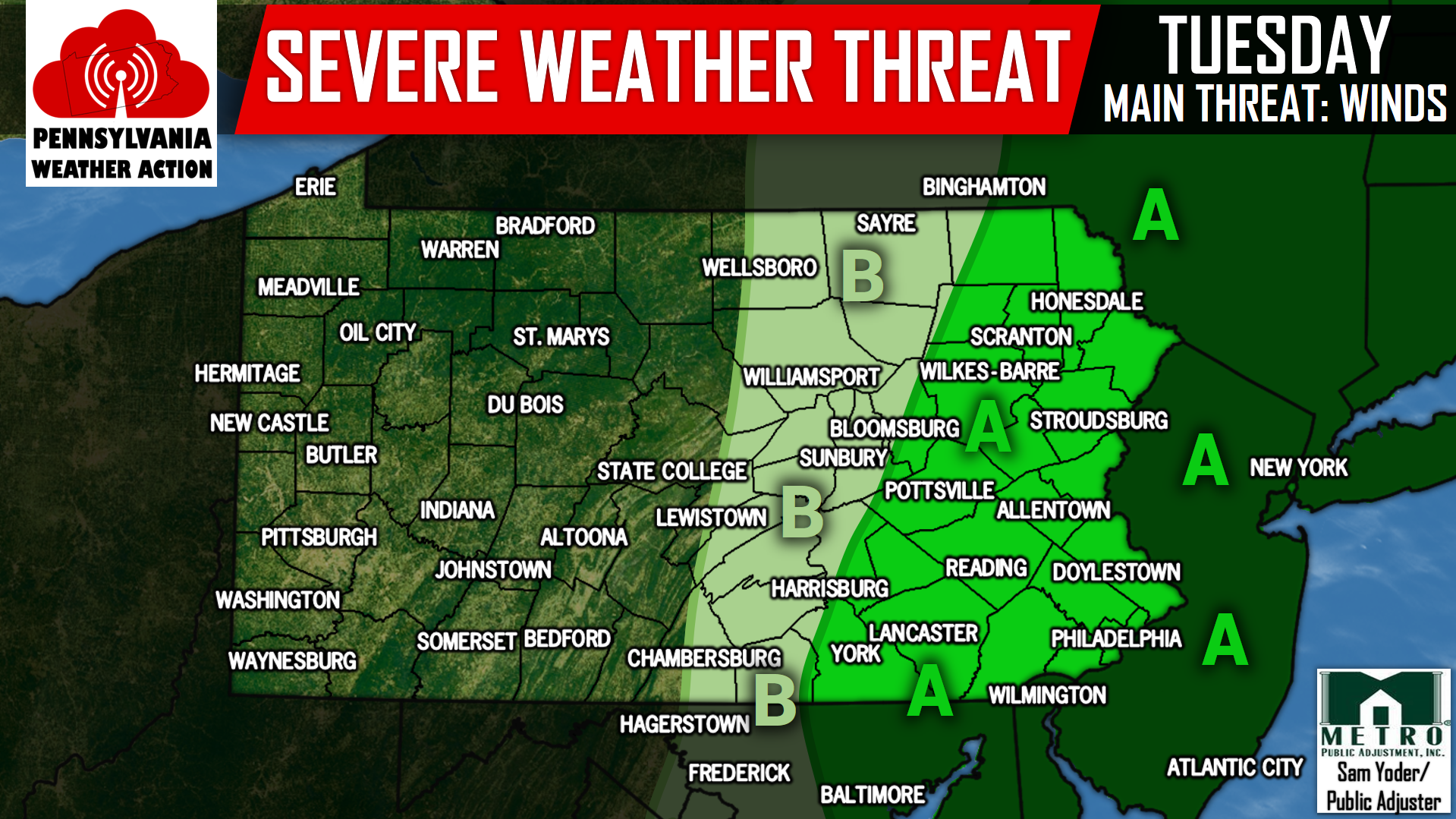
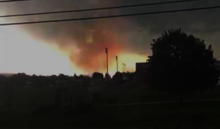
A tornado warned supercell thunderstorm moved through Adams and York County late this afternoon. The storms had a history of producing damaging winds and hail. Here is a video taken in West York, PA of what may be a tornado and a power flash. Check it out and give this video a share above!

Share833
833 Shares

Odds of Hurricane Irma Making Landfall Increasing

TropicsBy Lead Forecaster Josh AdamsSeptember 3, 2017

We have been receiving a lot of questions over the last couple days about Hurricane Irma and its potential impacts on Pennsylvania. We would love to give you all definite answers, but unfortunately we are far too early to be giving definite answers. However, we are going to give you all the latest forecast models…

Share2.41K
2.41K Shares
12345…
67
8
  • APP
  • WEATHER RADAR
  • SEVERE CENTER
  • AIR QUALITY
  • LONG RANGE
  • NRG PARTNERSHIP
  • CONTACT
MENU

© Copyright 2015-2022 Pennsylvania Weather Action, LLC. All rights reserved.

Go to Top
 

Loading Comments...
 

You must be logged in to post a comment.