

Good afternoon! It was quite a cool, cloudy and rainy weekend (especially on Saturday). Unfortunately, with the upper level low sticking around, we are continuing to see the effects linger into this afternoon with the cloudy conditions with hit-and-miss showers. However, this pattern will not be lasting much longer as a ridge of high pressure moves into our area, allowing for skies to clear and temperatures to climb. Toward the end of the blog, I will hint at what the pattern could be in turn for us this upcoming weekend (hint: it will not be too hard to guess with the conditions the last few weekends).
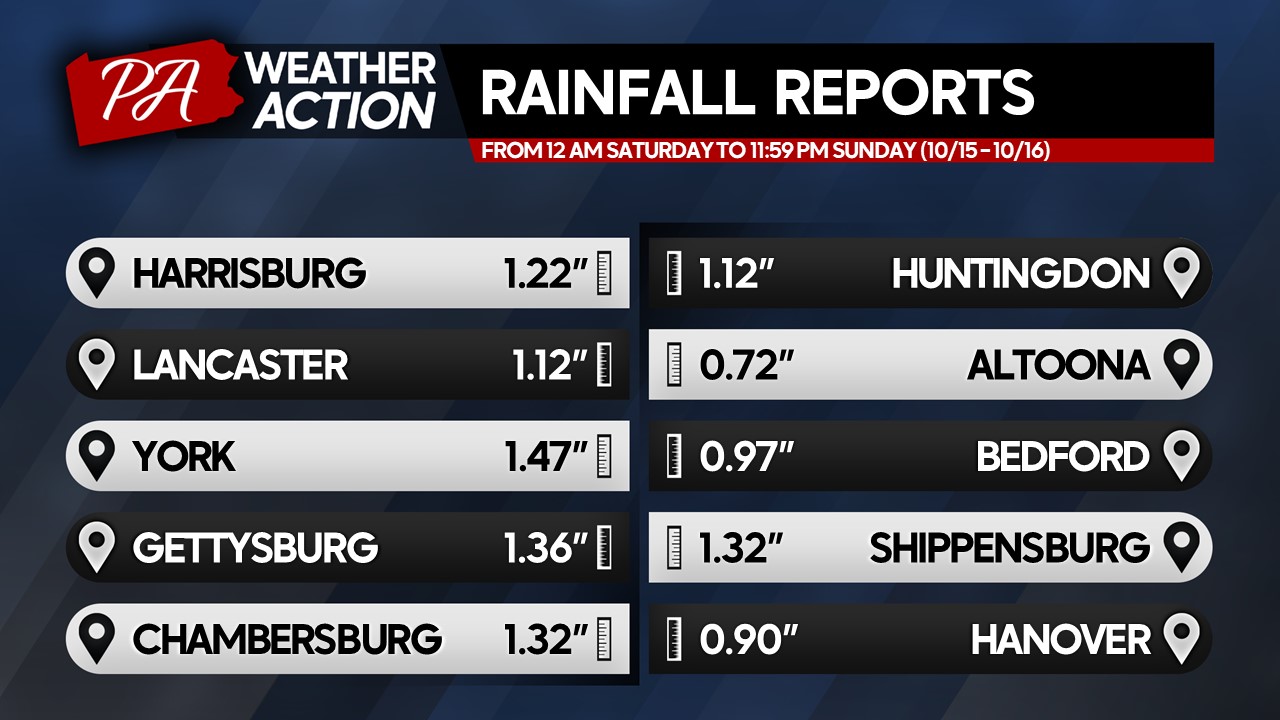
WEEKEND RECAP:
Taking a look at a quick weekend recap, much of the region received a decent amount of rain, with many locations picking up between 0.70 – 1.50″ across the area. While it was a beneficial rainfall to help cancel out some of our recent drier stretches (especially across the southern counties), it came at the wrong time as many outdoor plans were likely disrupted. Despite the rain and chilly conditions, I hope you had time to still make the best of the weekend! Anyway, let’s jump into this week’s forecast!
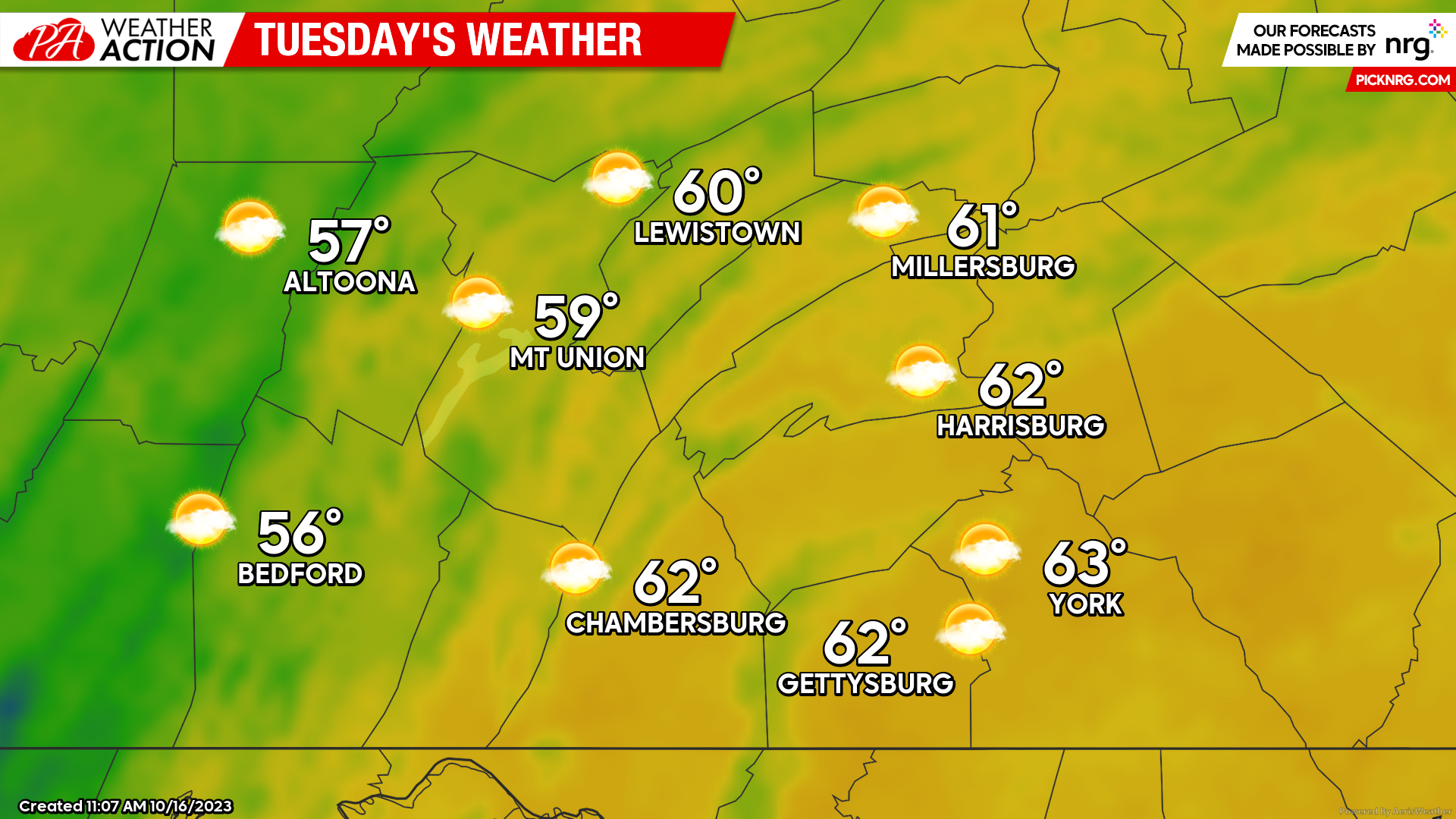
TUESDAY:
We will begin to climb out of the damp and cool post-weekend pattern as an area of high pressure begins to move into our region. Expect high temperatures to climb into the upper-50s to lower-60s with a mix of sun and clouds. Expect a slight northwesterly wind of 5-10 MPH during the afternoon hours with gusts up t0 15 MPH. Otherwise, it will be a great afternoon for anything outdoors!
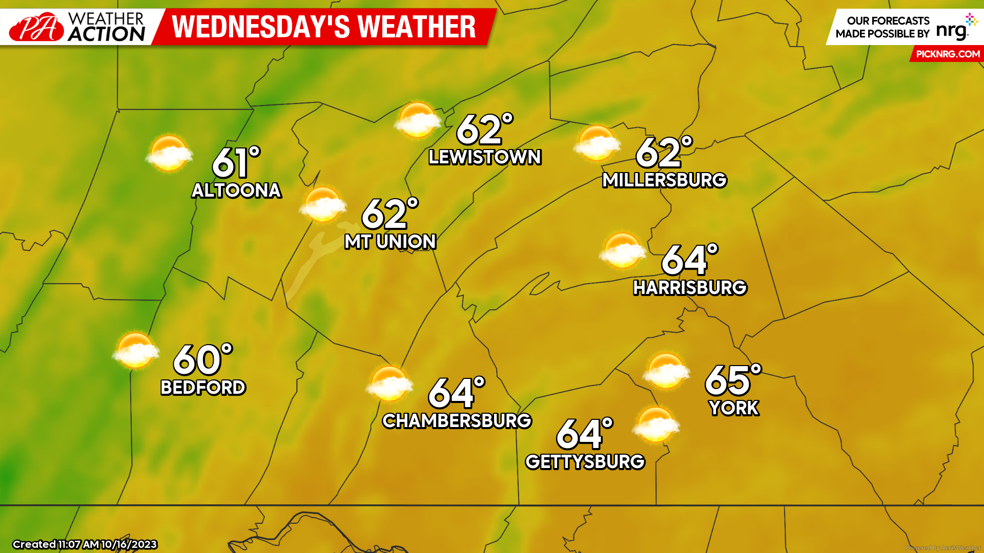
WEDNESDAY:
Heading into the middle of the week, high pressure in control over the region will allow for fair weather conditions across our area. Expect high temperatures to climb into the low-to-mid 60s with a mix of sun and clouds with a westerly wind of 3-7 MPH during the afternoon hours with gusts occasionally over 10 MPH. It will be yet another great afternoon for outdoor activities and to potentially check out some fall foliage across the region!
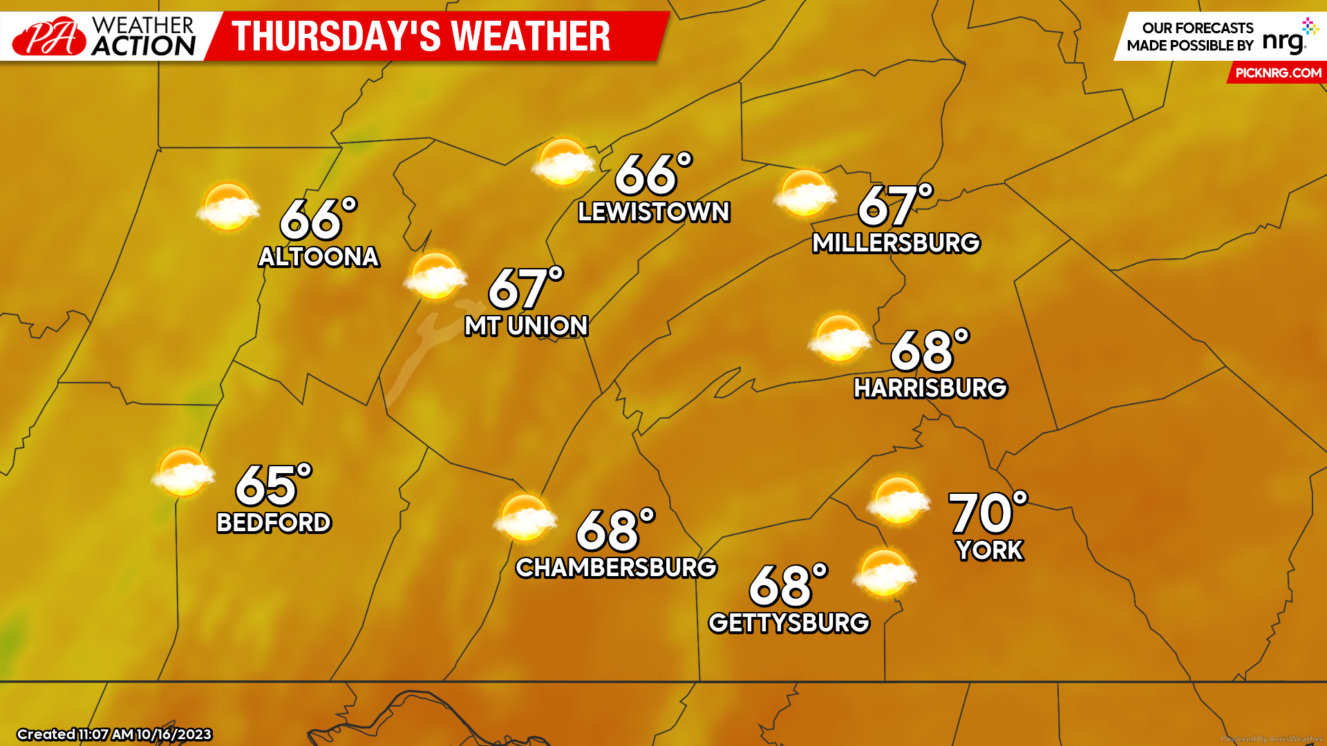
THURSDAY:
Ahead of an incoming cold front (which will move through Friday afternoon) our high temperatures will be peaking on Thursday. Expect high temperatures to rise into the mid-to-upper 60s with a few locations making it into the lower-70s (especially in the southern counties). With the higher temperatures, we will see a southerly wind of around 10 MPH with gusts up to 20-25 at times during the afternoon hours. Thursday will be the best day to get outdoors and to soak in the sunshine and warmth as going into the weekend the weather pattern will be significantly changing once again!
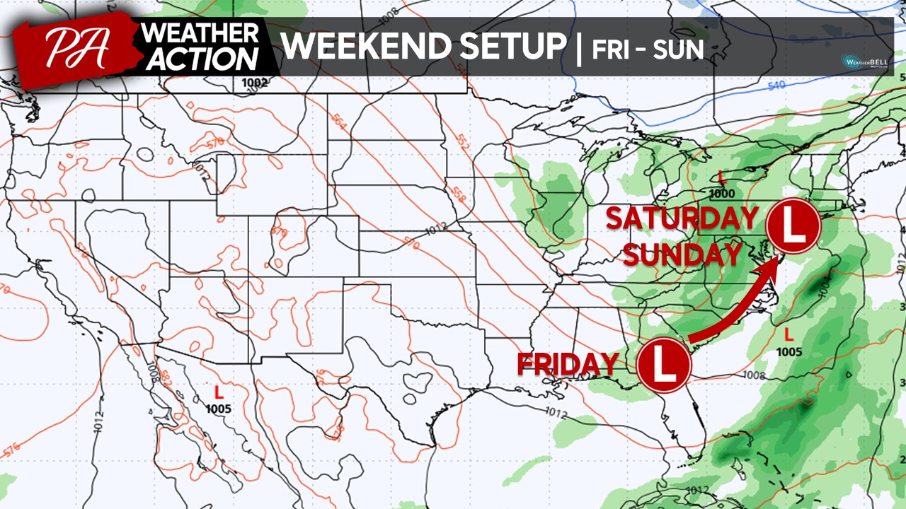
 HINTING AT THE WEKEEND:
Unfortunately it seems like we cannot catch a break when it comes to the weekend weather. As we head into the weekend, the pattern will become more favorable for a potential low pressure system to develop in the Southeastern United States and track up the Eastern Seaboard, bringing the threat for heavy rains and winds. For any winter weather weenies out there, this track closely resembles a “Miller A” snowstorm. However, with us still in the month of October, it will likely be too warm for any wintry precipitation. Anyway, with a “Miller B” track this past weekend, it makes you wonder if this is a sign of what is to come this upcoming winter? Back to the forecast, there is some indication that this low pressure system may occlude over our region, which may make it linger around for several days, impacting likely much of our weekend. However, there is still uncertainty in the exact track and strength of this potential low pressures system, so make sure to stay tuned for updates if you have any weekend plans!
Have a great week and try to soak in the pleasant conditions as much as you can! Winter is not that far off and it will not be much longer until we are swamped with much lower daily temperatures and cloudy skies for extended periods of time. If you have any questions regarding the forecast, feel free to reach out at anytime!
Denys
You must be logged in to post a comment.