
Good afternoon, I hope everyone has had a great start to their workweek! Ever since the cold front passage on Saturday morning, we have been stuck in a cool pattern with temperatures generally in the 50s under mostly cloudy skies and a stout northwesterly wind. Moving forward, it is likely we are officially stuck in a fall pattern. However, there are some changes coming over the next few days, including slightly warmer conditions and the threat for a potential weekend washout.
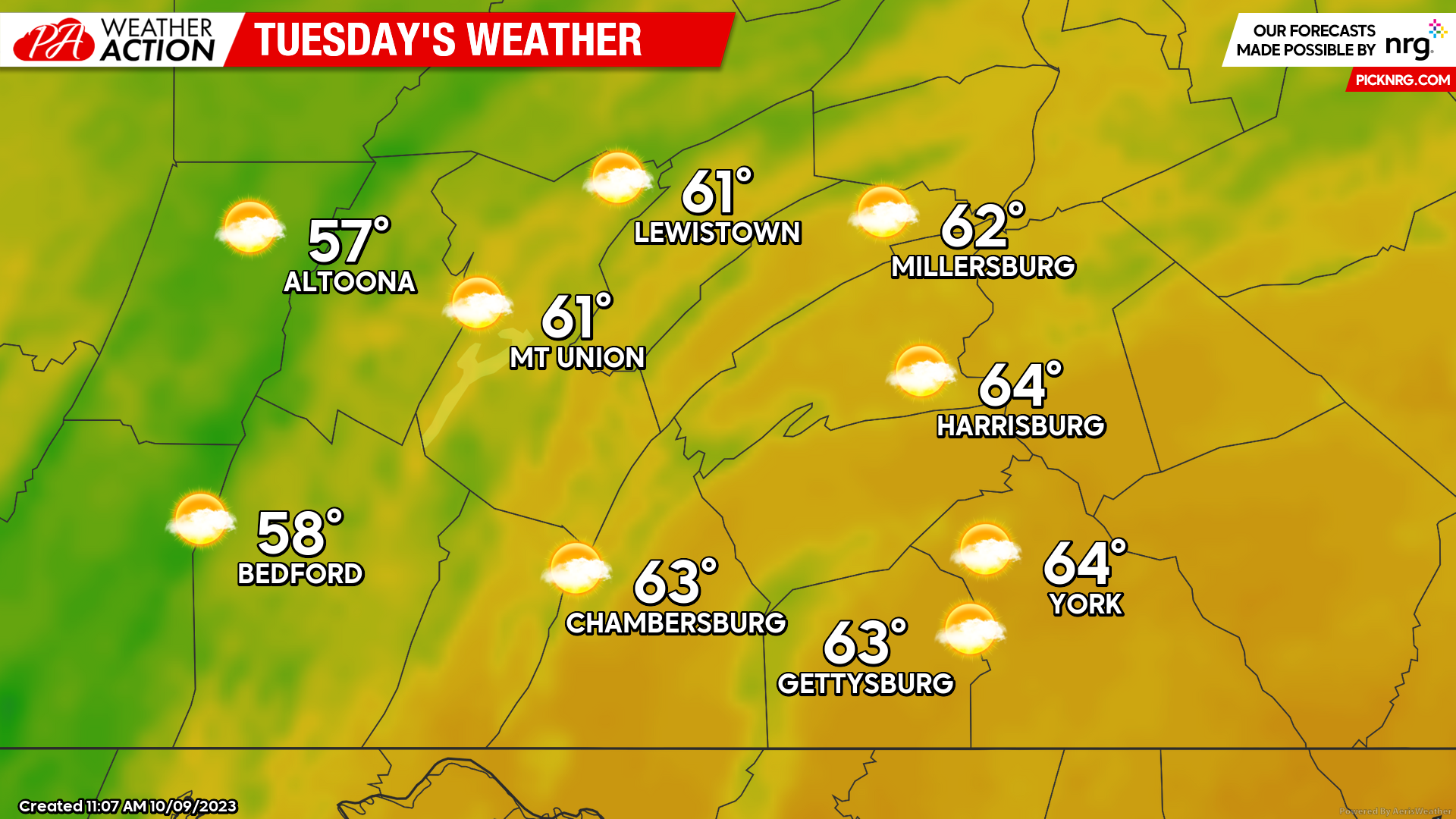
TUESDAY:
Expect warmer conditions compared to the last few days, with high temperatures reaching into the upper-50s to lower-60s under a mix of sun and clouds. Expect a westerly sustained wind of 10-15 MPH during the afternoon hours, occasionally gusting up to 30 MPH. It will not be too bad of an afternoon!
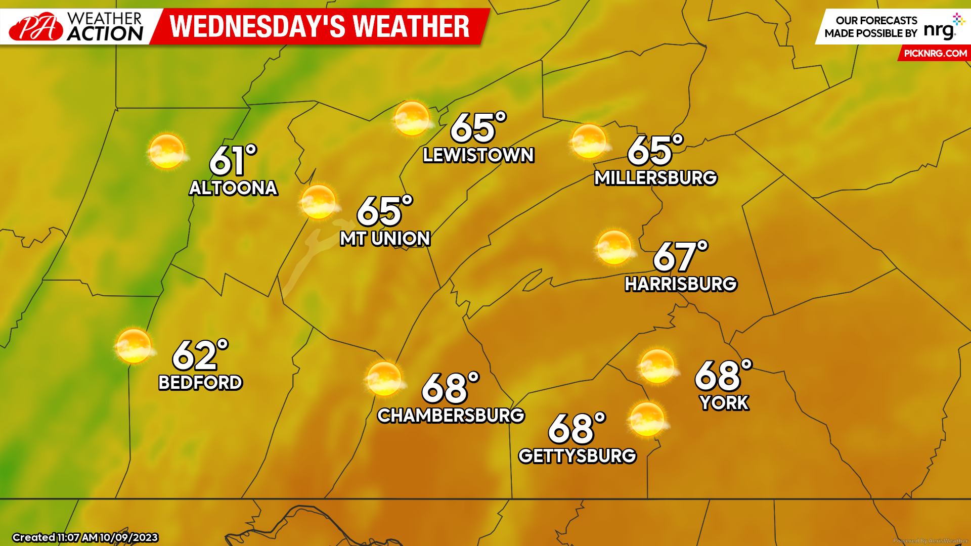
WEDNESDAY:
Wednesday will likely be the nicest day of the week with high temperatures climbing into the low-to-upper 60s for much of the region under mostly sunny skies. The wind will be calmer as well, with sustained winds of 3-7 MPH out of the west. If you can, get outdoors to soak in the sunshine and warmth because some changes will be coming as we go into the latter half of the week.
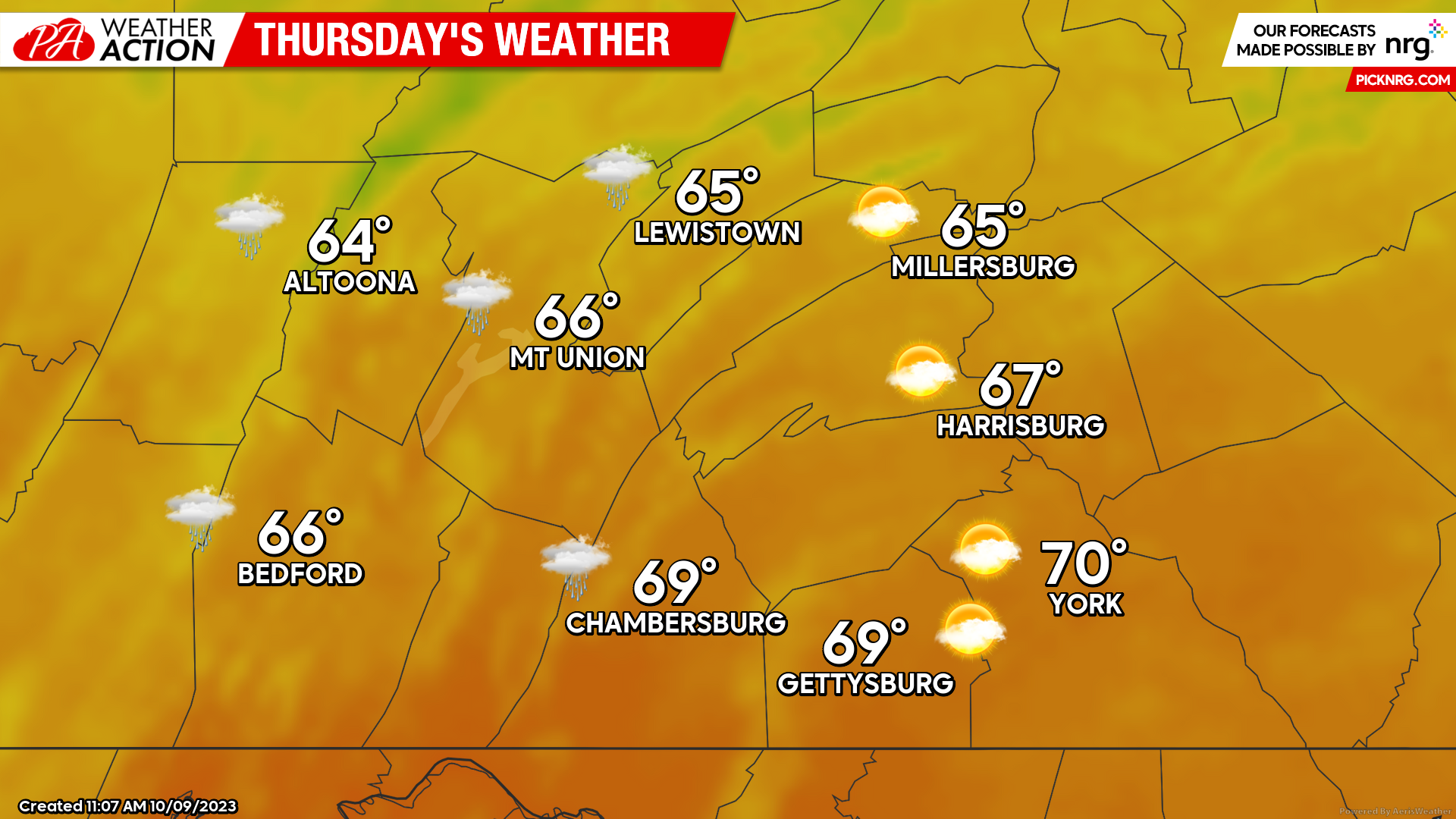
THURSDAY:
Thursday will bring changes to the pattern as a warm front lifts into the region. Expect the warm front to split the state in half (north-to-south), with higher temperatures in the far southern regions and lower temperatures as you head further north. Additionally, expect the threat for showers associated with the warm front, primarily across the western and northern parts of the region.
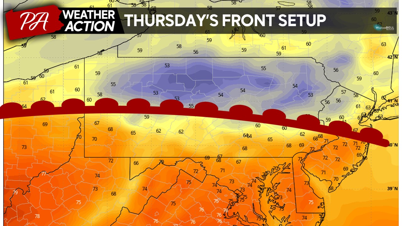
Expect temperatures to reach the upper-60s/lower-70s across the far southern counties during the afternoon hours while those closer to and north of the warm front to see only highs reach the upper-50s/lower-60s with scattered on-and-off rain showers. These rain showers should be light in intensity and overall short in duration, so Thursday should not be a complete washout for any part of the region.
WEEKEND WASHOUT?
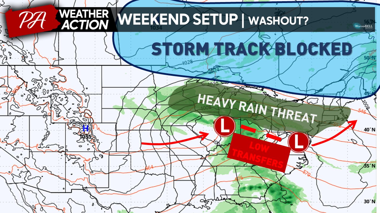
Looking ahead toward the weekend, unfortunately, the odds are increasing for unsettled weather conditions. A low pressure system that is expected to develop across the central United States will ride along the periphery of the warm front, which will allow for widespread precipitation to return to the area late Friday night into the day on Saturday.
What is leading to this setup to occur? Keep the idea that systems like to follow the flow of the least resistance. A low pressure system will track over the central United States and move into portions of the Ohio Valley Wednesday through Friday. However, due to an area of sinking air (blocking) across much of southern Canada, this provides a lot of resistance to the flow, and the low pressure system will be stopped in its tracks. This forces the area of energy associated with the low pressure system to transfers somewhere inside the Mid-Atlantic region, where there is lower pressure, sometime late Friday into Saturday morning. This will lead to an area of increased precipitation across where the low pressure systems track and re-develop, which unfortunately falls into our local region.
Taking a look at the current model projections between the GFS (American) and ECMWF (European) models, there is still a variety of disagreement on the magnitude of the rainfall. The
The GFS (American) model is a far lot drier for the weekend rainfall forecast, with rainfall amounts generally staying below an inch across the region. Typically, when low pressure systems transfer their energy, the central portions of the state may be in the “lull” of the precipitation, allowing for lower overall precipitation amounts. 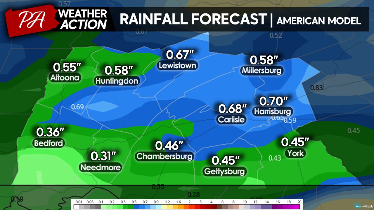
The ECMWF (European) is significantly wetter compared to the GFS, which allows for a widespread 2-3″ of rain throughout the weekend. It has a quicker transfer of energy between the low pressure systems, which allows for a quicker rebuilding of the precipitation shield once the secondary low gets going across the Mid-Atlantic. This allows for far more significant precipitation across the region and this scenario cannot be completely ruled out.
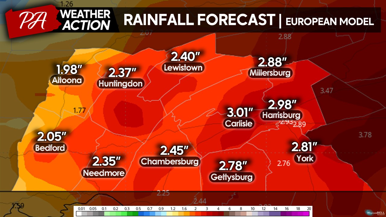
However, even with the current disagreement, it is becoming more and more likely that there will be some rain falling across the region this weekend, primarily on Saturday. Unfortunately, this setup would have been more interesting if we were in the middle of winter, as these setups usually lead to areas of heavier wintry precipitation across our region. Since we are still in early October, this will be a very cold rain event (temperatures in the lower-40s) and will likely damper any outdoor weekend plans. If you have any outdoor plans, it is time to start thinking of possible alternatives – but hold off from cancelling just yet in case the forecast changes!
Stay tuned for more updates regarding the weekend threat! If you have any questions regarding the forecast, feel free to reach out. Download the PA Weather Action for more up-to-date information!
Denys

You must be logged in to post a comment.