
Snow is coming down across nearly all of Northern Pennsylvania as well as parts of Eastern PA. By late evening precipitation will move back into Southern Pennsylvania starting as snow for many in the Laurel Highlands to Susquehanna Valley. By midnight snow will begin to move into Eastern PA, while precipitation type in Southcentral PA switches to freezing rain. In addition, Northern Pennsylvania will be seeing light snow.
By 3-5 AM, temperatures will begin to warm above freezing in Southern PA and Eastern PA. Light to moderate snow will continue in Northern PA before ending as a short period of rain after 9 AM.
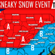
MAP FORECAST FOR WINTER STORM
Area A – Snow continuing through Monday Morning before ending with a very short period of light rain possibly. Snow accumulation of 4-6″. Snow packed roads likely Monday Morning.
Area B – Snow will be on and off through midnight before starting up again until dawn Monday Morning. Light rain is then possible only for a few hours. A slight glaze of ice is possible. Snow accumulation of 2-4″. Slushy road conditions possible Monday Morning.
Area C – Snow will redevelop late Sunday Evening into Early Monday Morning before changing over to freezing rain for a short period, followed by another short period of rain. A slight glaze of ice is possible. Snow accumulation of 1-2″. Slick road conditions likely Monday Morning.
Area D – A short period of snow Late Sunday Evening before changing over to rain. A slight glazing of ice is also possible. Snow accumulation of less than 1″.
Area E – A short period of snow is likely around 12 AM Monday before changing over to freezing rain until about 3-4 AM. A glaze of ice is likely. Snow accumulation of less than 1″. Slick road conditions possible Monday Morning.

Don’t forget to like Pennsylvania Weather Action on facebook and share this forecast below. Stay safe everyone!

You must be logged in to post a comment.