
A rapidly intensifying, but fast moving coastal storm will push up the Atlantic Coast, bringing a period of heavy snow to the state. Timing will vary, as Western PA will see most of its snow tonight, and the eastern two thirds of Pennsylvania will see its snow Saturday morning and early afternoon. This will be a 6-10 hour snow event depending where you are, so if you don’t absolutely need to travel during that time, then don’t. While it’s warm today, it won’t matter with the heavy snow rates. Paved surfaces, even treated, will probably still become slushy and slippery.
TIMING
As mentioned, the majority of the snow in Western Pennsylvania will fall overnight, between 11 PM – 7 AM. That is when travel conditions will be worst. Fortunately, not too many people will be traveling during that time. The advantage though, is that there will be no sun angle to deal with. Snowfall will break out in Central PA from west to east between 4 – 7 AM, after briefly starting as rain. The snow will that depart from west to east by 11 AM – 3 PM. Finally in Eastern PA, a brief period of rain will change to heavy snow in the Poconos around 7 AM, and Southeast PA by 10 AM. It will then shut off from west to east around 3 – 5 PM. Below is the latest Hi-Res NAM Future Radar.
FINAL CALL SNOWFALL FORECAST FOR SATURDAY’S SNOWSTORM
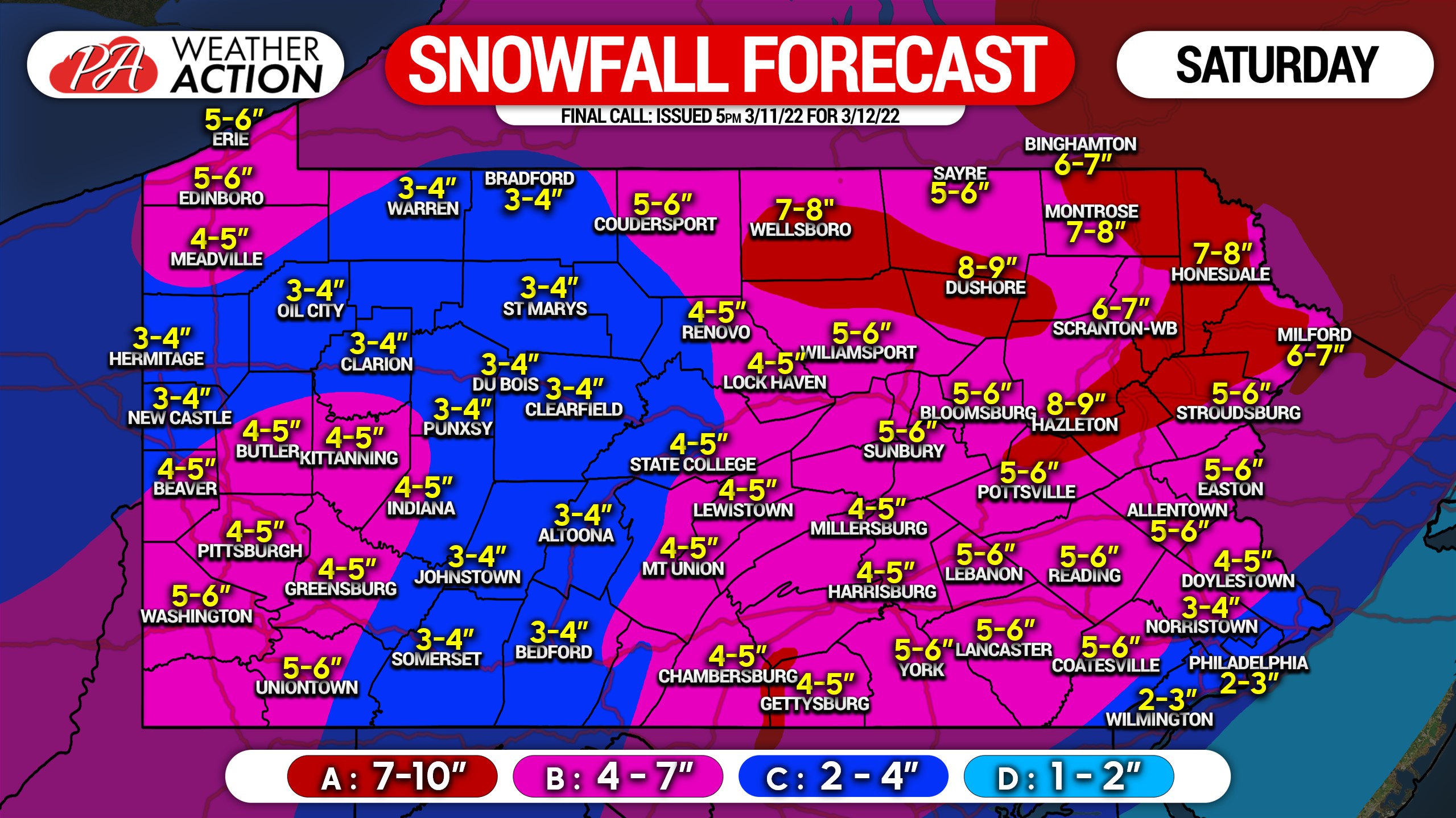
Area A: Snowfall accumulation of 7 – 10″ expected. Snowfall rates of 1-2″/hour likely, along with wind gusts of 35-50mph. Travel will be very difficult to near-impossible mid-Saturday morning through late afternoon.
Area B: Snowfall accumulation of 4 – 7″ expected. Snowfall rates of up to 1″/hour in Western PA, and up to 1-2″/hour in Eastern PA, along with wind gusts of 35-45mph. Travel will very difficult Saturday morning in Western PA and mid-Saturday morning to late afternoon in Eastern PA.
Area C: Snowfall accumulation of 2 – 4″ expected. Snowfall rates of up to 1/2″/hour in Western PA, and up to 1-2″/hour in SEPA likely during the changeover, along with wind gusts of 30-40mph. Travel will be difficult Saturday morning in Western PA and late Saturday morning to late afternoon in SEPA.
Area D: Snowfall accumulation of 1 – 2″ expected. Snowfall rates of 1″/hour likely during the changeover, with an hour or two of snow expected, along with wind gusts of 30-40mph. Travel may be slippery during the heavy snow early Saturday afternoon.
Please do not travel unless you must during the heavy snow. It won’t last too long, and should be cleared shortly after. But when it’s falling, low visibilities and hazardous travel conditions will occur.
Be sure to share this with family and friends who have plans Saturday.
[social_warfare]
Track the changeover with our app’s map layers, along with your hourly forecast and our updates. Tap below to get the app!


You must be logged in to post a comment.