
We are officially less than 24 hours away from the start of what will be remembered as one of the biggest snowstorms to hit Pennsylvania in December in recorded history. Latest model data and observations have suggested that our forecast map from yesterday will have to be changed, with totals bumped northwest. The biggest changes will appear across western Pennsylvania where snow amounts have been upgraded. Much of central and northern Pennsylvania have been upgraded as well. It appears right now, the coastal storm will take a track closer to our region, allowing for mixing to impact much of southeast Pennsylvania for time period before changing back to snow. This will result in slightly less snowfall accumulations for these areas.
TIMING:
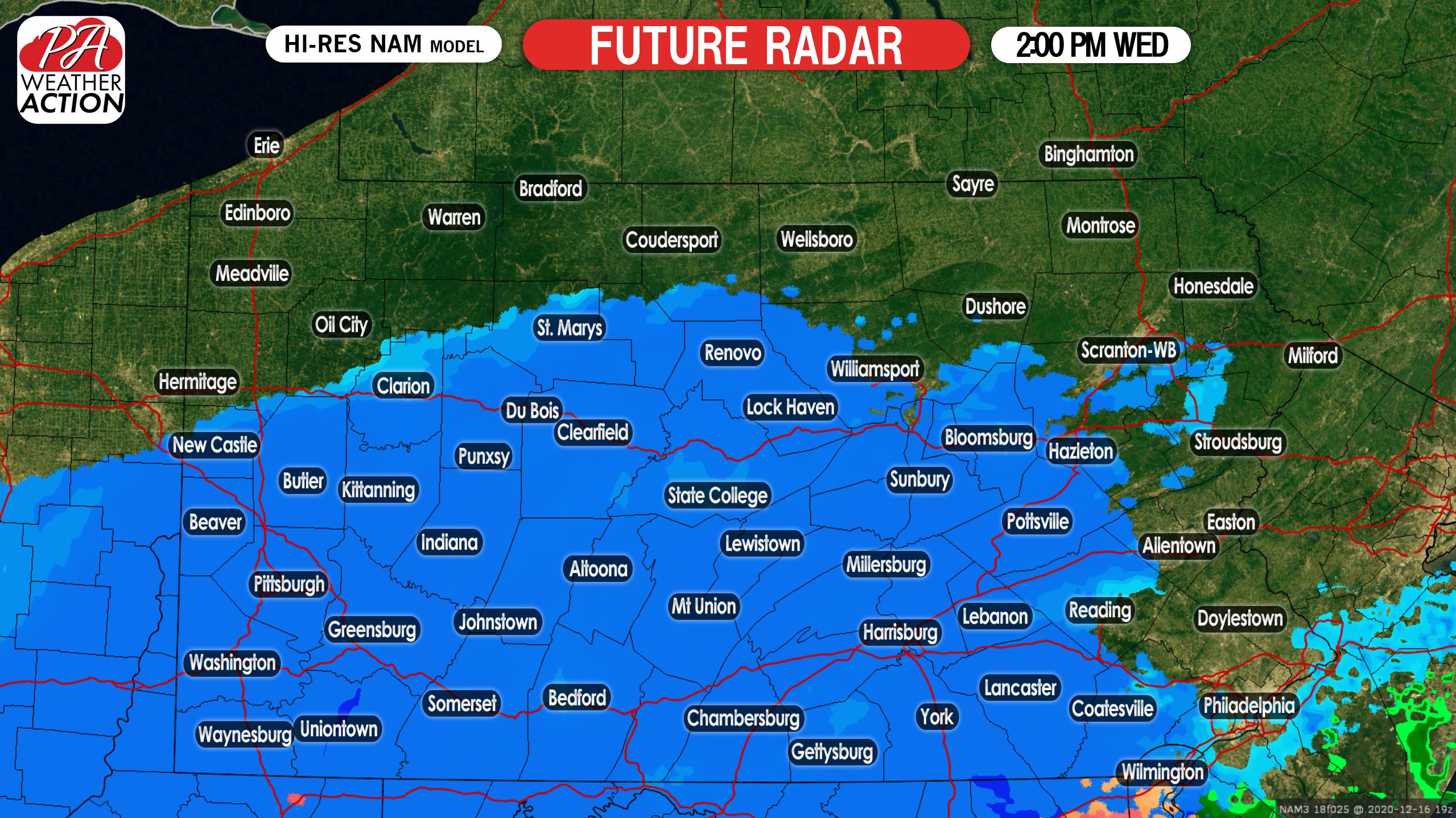
Please note that the first half of Wednesday will remain dry for most areas. So do not think it is a bust if you do not see snow flying until the afternoon. That is expected for most locations. Snow will move in from south to north starting in the far southern tier around 10:00 AM and then not until the early afternoon hours for northern Pennsylvania. By 2:00 PM Wednesday afternoon, much of the state is under steady snow, especially southwest Pennsylvania:
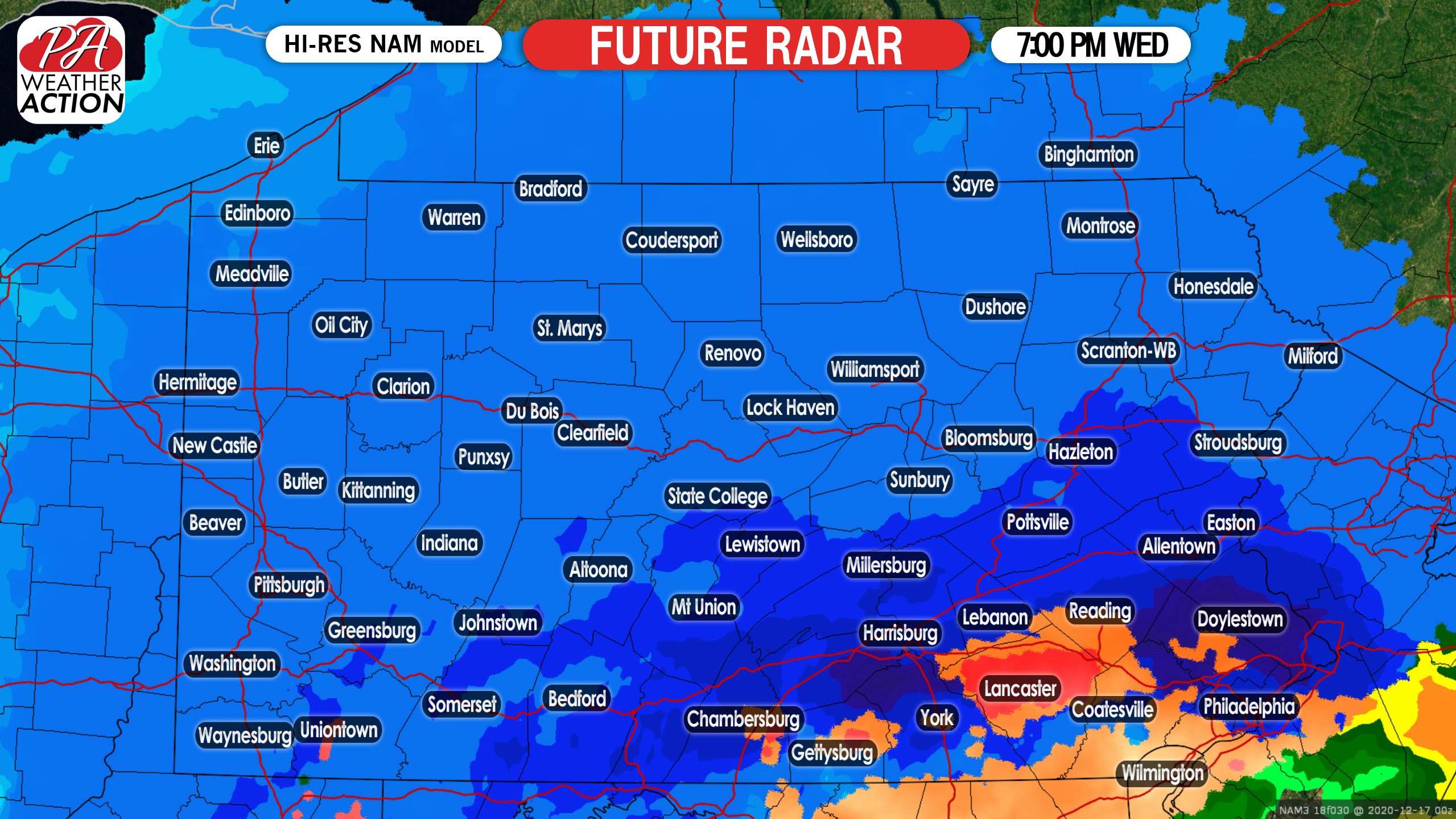
Later in the afternoon on Wednesday, snowfall rates will increase. The heaviest of the snow will begin to fall after 4:00 PM, when 1 to 3 inches per hour of snow is likely. By 7:00 PM, just about the whole state is under moderate to heavy snow. Keep an eye on southeastern areas. There is a good chance these areas mix with and change to sleet at some point Wednesday evening for at least a couple hours. This will keep snow totals on the lower side for these locations:
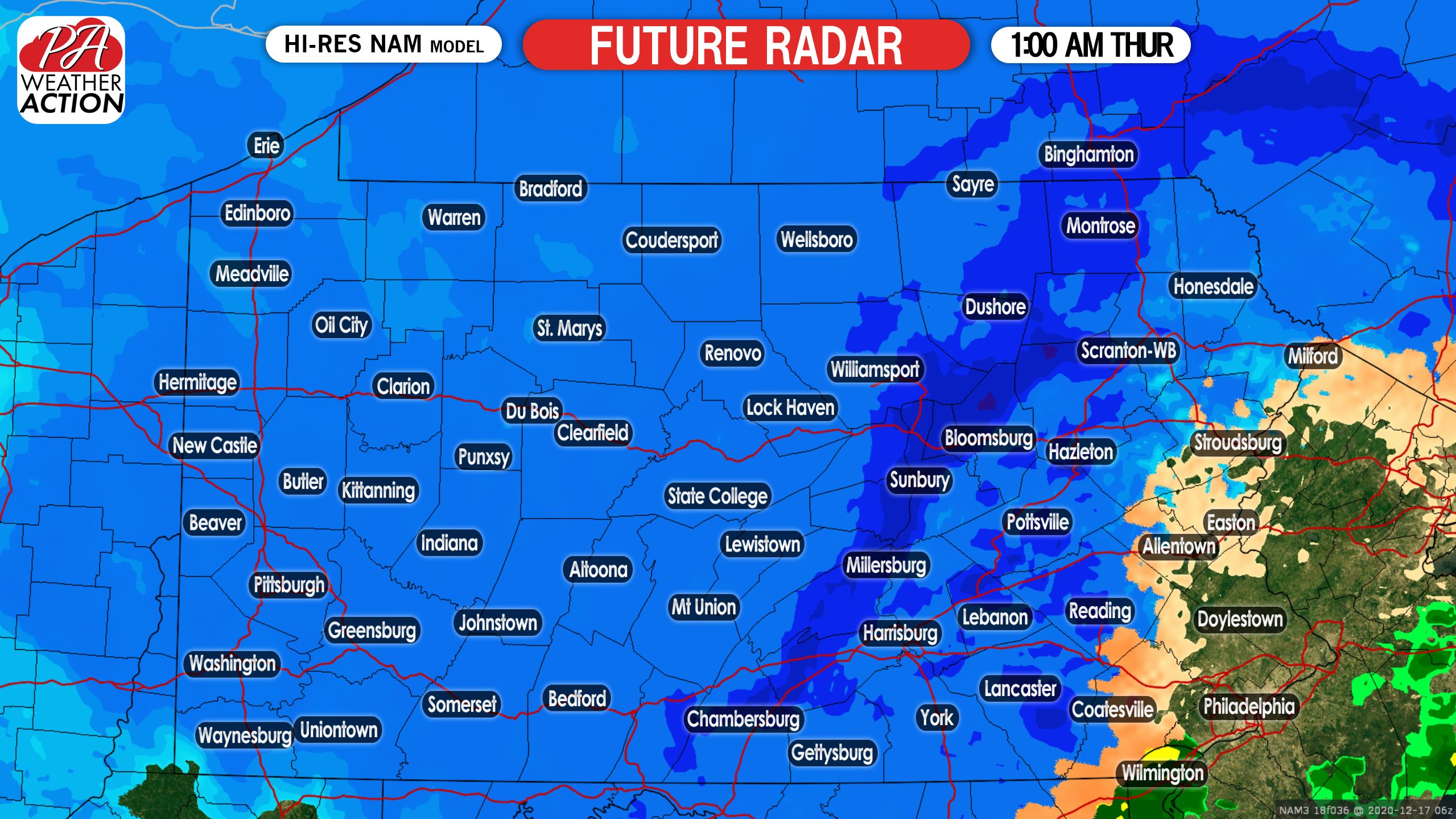
During the overnight hours, the coastal low will really start to strengthen. This will cause wraparound heavy snow bands to take place. Where these heavy snow bands setup, is the areas that will jackpot from this storm. Currently it looks like a good portion of central Pennsylvania is in that jackpot area. Below is a look at 1:00 AM Thursday morning:
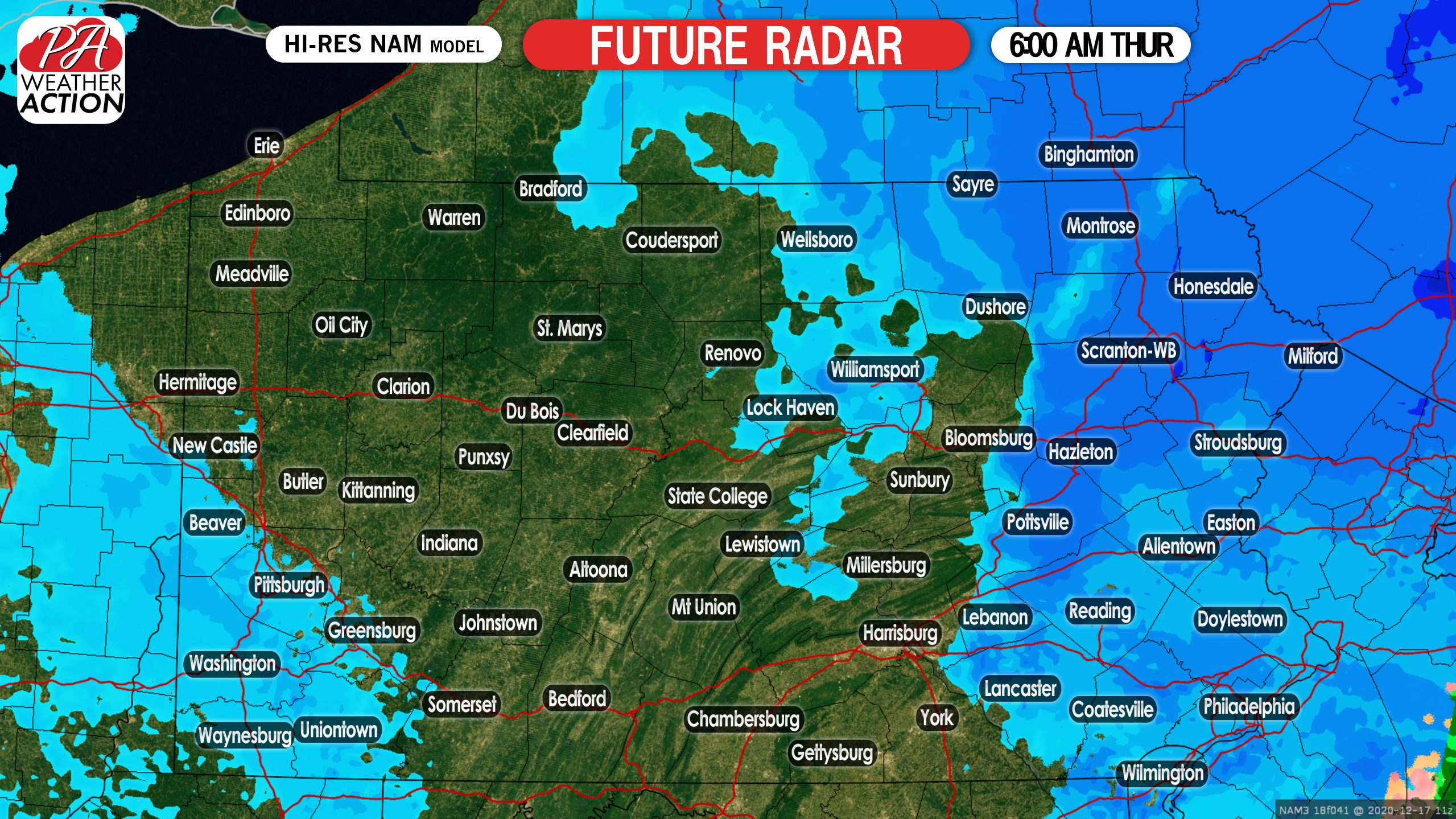
While parts of eastern Pennsylvania may mix with sleet, these areas will change back to moderate to heavy snow as the coastal storm begins to pull away. Below is a look at 6:00 AM Thursday morning:
FINAL CALL FOR WEDNESDAY PM – THURSDAY AM MAJOR SNOWSTORM
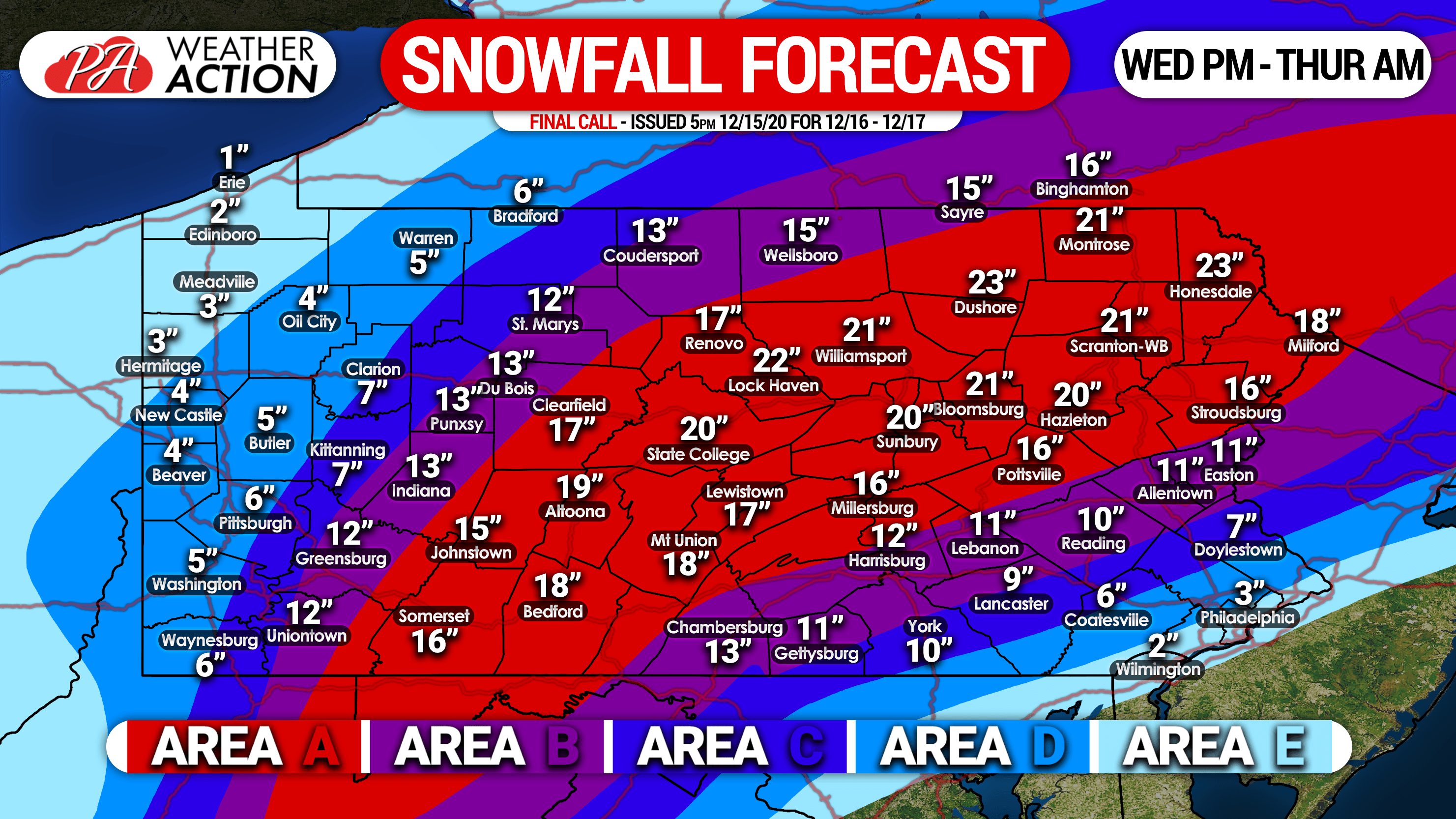
Area A: Snowfall accumulation of 15 – 25″ is anticipated. Snowfall rates of 1/2″ to as high as 3″ per hour are expected across an 18 hour period, starting Wednesday afternoon through Thursday morning. Travel will be nearly impossible during and just after the storm. Scattered power outages will be likely.
Area B: Snowfall accumulation of 10 – 15″ is expected. Snowfall rates of 1/2″ to as high as 3″ per hour are anticipated over a 15 hour period, from Wednesday afternoon through early Thursday morning. Sleet will likely occur on the eastern side of this regions for a few hours in the evening. Travel will be very difficult to impossible during and just after the storm. Isolated power outages will be likely.
Area C: Snowfall accumulation of 6 – 10″ is anticipated. Snowfall rates of 1/2″ to as high as 2″ per hour are likely across a 15 hour period, starting Wednesday afternoon through early Thursday morning. Locations on the eastern side of this zone are expected to see sleet for several hours in the evening. Travel will be difficult during and just after the storm.
Area D: Snowfall accumulation of 3 – 6″ is expected. Light to moderate snow is expected over a 12 hour period from Wednesday afternoon into early Thursday morning. The eastern portion of this area will start as snow, turn to sleet for several hours, and end as snow.
Area E: Snowfall accumulation of 1 – 3″ is anticipated. Light snow over a 9 hour period from Wednesday afternoon through the late evening is expected on the western side of this area, and sleet is expected for most of the storm on the eastern edge.
Track you hourly forecast, radar, and much more in our app! For that and much more, get our new Apple & Android app here! >>> Weather Action App Link
This will be a historic storm with severe impacts. Be sure your family and friends have the latest forecast, using the blue button below.

You must be logged in to post a comment.