After a very long break, Mother Nature is reminding us that is is still winter. Although below average temperatures won’t arrive for another two weeks, parts of the state will have two opportunities for snow in the coming week. The farther south and west you are in Pennsylvania, the lower your chances are to see snow from either, and vice versa.
Storm Timing
Precipitation will move in from west to east during late Monday afternoon in Central PA, and the early evening in Eastern PA. It will likely start briefly as snow in Central PA, before changing to a snow/sleet mix for much of the storm near and north of I-80. Between I-80 and I-76 (PA Turnpike) in Central PA, an extended period of sleet is likely Monday evening.
Over in Eastern PA, north of the Lehigh Valley, including all of the Poconos, snow will be the dominant precipitation type through Monday night, which will be heavy at times. The Lehigh Valley itself will be a battle zone between snow and sleet, resulting in lower snowfall amounts. Areas seeing all rain include Western PA, locations south of the PA Turnpike in Central PA, and locations south of Reading and Doylestown in Eastern PA.
Freezing rain may lead to ice accrual on higher ridgetops in Central PA.
Precipitation will move out from west to east between 2-5 AM Tuesday in Central PA and 5-8 AM Tuesday in Eastern PA. Some very light precipitation may continue after those times.
Here is future radar from this evening’s High Resolution NAM model.
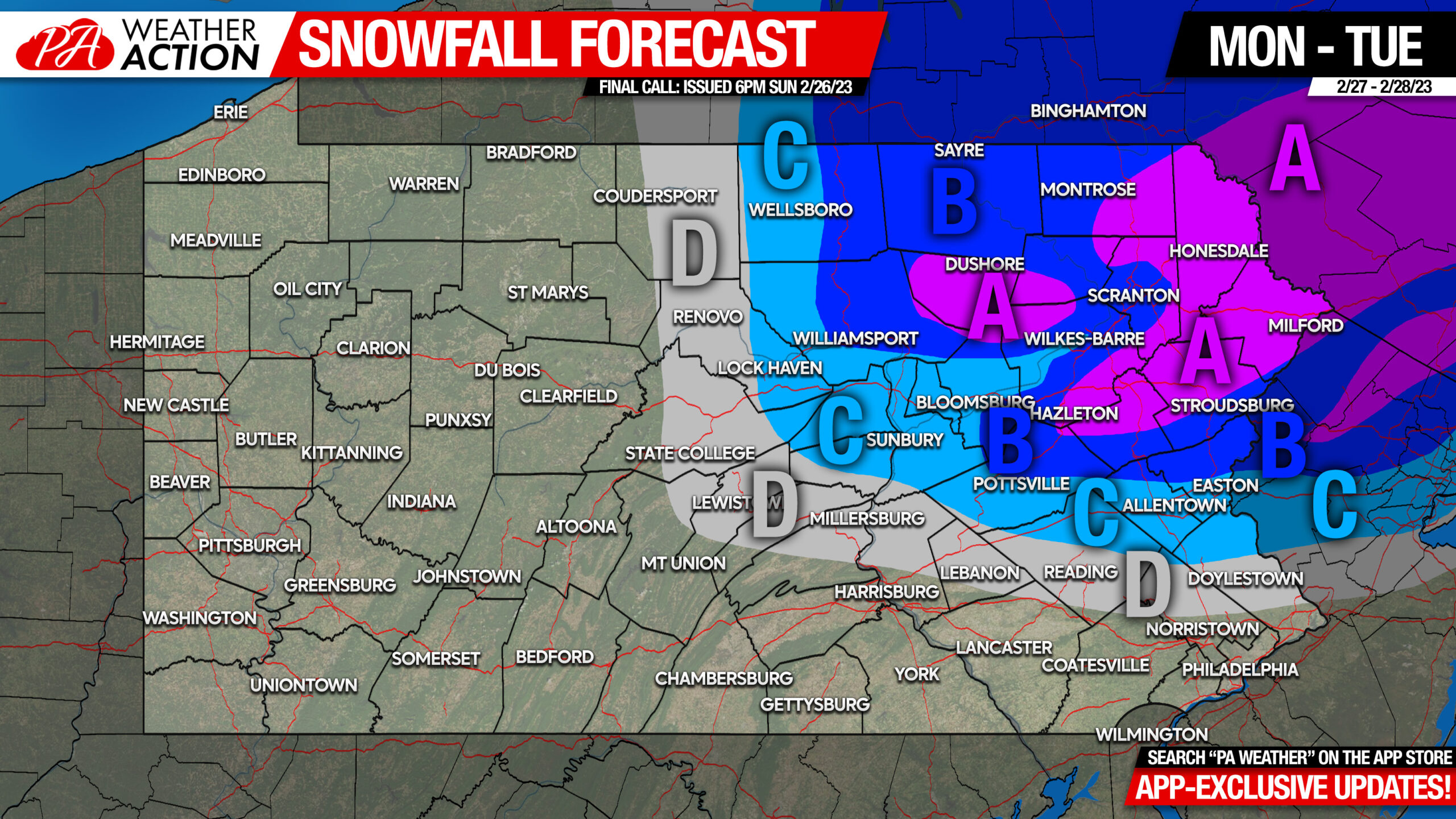
Monday Evening – Tuesday Morning Snowfall Forecast
Area A: Snowfall accumulation of 4 – 7″ expected. Difficult travel is likely late Monday evening through mid Tuesday morning.
Area B: Snowfall accumulation of 2 – 4″ expected. Difficult travel is likely mid to late Monday evening through early Tuesday morning.
Area C: Snow and sleet accumulation of 1 – 2″ expected. Difficult travel is likely during times of heavier precipitation late Monday evening through early Tuesday morning.
Area D: Snow and sleet accumulation of less than 1″ expected. Difficult travel possible late Monday evening.
Not the biggest storm, but certainly not one to downplay especially given that road impacts are nearly certain. Fortunately, the bad weather coming at a time many people will be home.
If you know anyone who may be out during the impact period, consider sharing the forecast with them below.
[social_warfare]
We will have in-depth model updates and latest thinking regarding the Friday – Saturday larger storm potential in our app. There is a week free trial period for those updates, so you can cancel after this week if you’d like. Tap the banner below if you’re interested!


You must be logged in to post a comment.