
FINAL CALL SNOWFALL FORECAST POSTED (UPDATED SATURDAY 5 PM):
FINAL Call Snowfall Forecast for Sunday – Monday’s Major Winter Storm
A major winter storm will travel up the East Coast Sunday and deliver varying impacts to Pennsylvania. The bullseye will be in parts of Western Pennsylvania thanks to this storm cutting off from the rest of the jet stream and darting north thanks to the lack of a high pressure to our northwest. This is an abnormal track and there are still variables to the forecast that will need to be ironed out. The biggest wildcard will be just how much warm air makes its way in just a few thousand feet above our heads. Some model guidance indicates much more sleet, which may limit the front-end thump of snowfall east of the Alleghenies.
TIMING
All of us except the immediate Philadelphia Metro will start as a period of heavy snow from south to north Sunday Evening. This is when most of our snow will fall in Central and Eastern PA. That sleet line will then make its way in from the southeast, across areas of Central PA and all of Eastern PA late Sunday Evening to very early Monday Morning. During that time, all of Western Pennsylvania is likely to be seeing heavy snow continuing, perhaps with sleet pellets near the Monongahela River. A deformation band of very heavy snow is expected to setup in Northwest PA mid-Monday Morning, which is where the highest totals will be. The storm will then lift off to the northeast, changing all of us back over to a short period of light to moderate snow Monday Morning. Below is future radar timing for the entire storm.
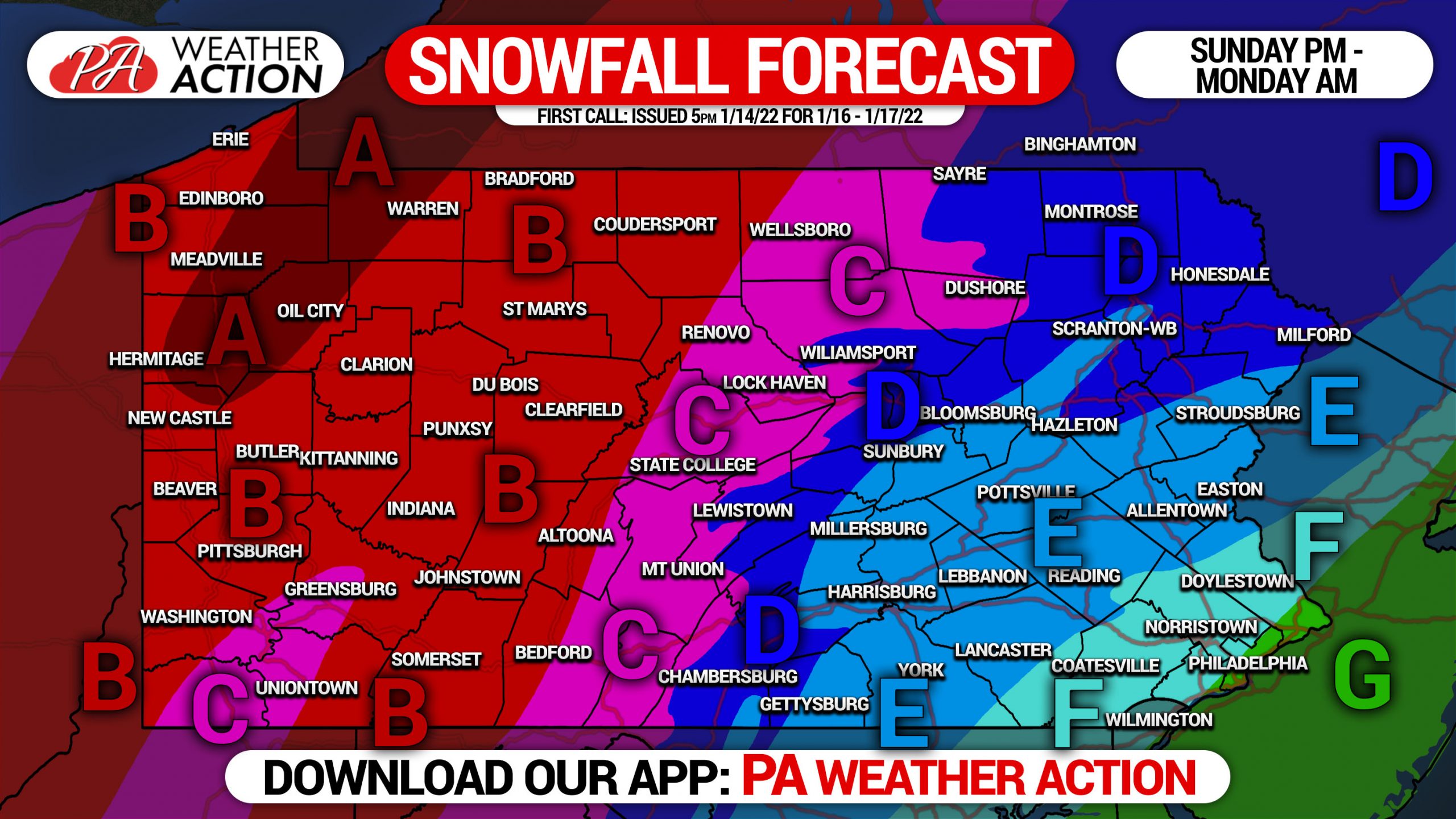
FIRST CALL SNOWFALL FORECAST FOR SUNDAY – MONDAY
Further details regarding timing and forecast variables are above.
Area A: Snowfall accumulation of 12 – 18″ expected. These locations will stay all snow, with a deformation band anticipated to setup over this region Monday Morning. Snowfall rates of up to 2″ per hour possible.
Area B: Snowfall accumulation of 8 – 12″ expected. These locations will stay all snow. Snowfall rates of up to 1-2″ per hour possible.
Area C: Snowfall accumulation of 6 – 8″ expected. Some sleet will mix in early Monday Morning. Snowfall rates of up to 1-2″ per hour possible.
Area D: Snowfall accumulation of 4 – 6″ expected. Snow to begin, then sleet and perhaps some freezing rain, then back to a brief period of snow mid-Monday Morning. Snowfall rates of up to 1-2″ per hour possible at the onset.
Area E: Snowfall accumulation of 2 – 4″ expected. Snow to start, followed by a changeover to sleet, and then rain by early Monday Morning. Perhaps ending as a brief period of snow by mid-Monday Morning.
Area F: Snowfall accumulation of 1 – 2″ expected. A brief period of moderate snow to start, followed by sleet and then mainly rain.
Area G: All rain expected.
Once again, the wildcard with this storm will be sleet. We may be tightening the snowfall gradient in following forecasts as short range models give us more details.
Be sure to share this important forecast with family and friends if in higher-impact areas.
[social_warfare]


You must be logged in to post a comment.