
Our highly awaited major winter storm will soon be on our doorstep, and while some will be stepping outside Monday Morning to a winter wonderland, others will be greeted by a soggy mess. This cutoff low pressure system will take a rare track right into South Central PA, which is perfect for a snow bullseye in Northwest Pennsylvania, and quite the gradient across the state.
TIMING
Snow will begin in Southern Pennsylvania around 4 – 7 PM Sunday Evening, and quickly lift north to the New York border by 10 PM. By late evening, snow will already change to sleet east of I-99 in Central PA and all of Eastern PA, from south to north. That sleet line will make it all the way to the New York Border, east of Wellsboro, south of Elmira, NY and Binghamton, NY. Meanwhile, moderate to heavy snow will continue falling across Western Pennsylvania. There may be some sleet mixed in around the Monongahela river, which we have highlighted on the snow map. A deformation band of very heavy snow with rates of 2-3″ her hour is anticipated to setup mid-Monday morning in Northwest PA. Wrap around precipitation will then lift out late Monday morning, possibly bringing a few snow showers back to Central and Eastern PA, but no additional accumulation is expected in those areas after changing to sleet.
Below is future simulated radar for the storm.
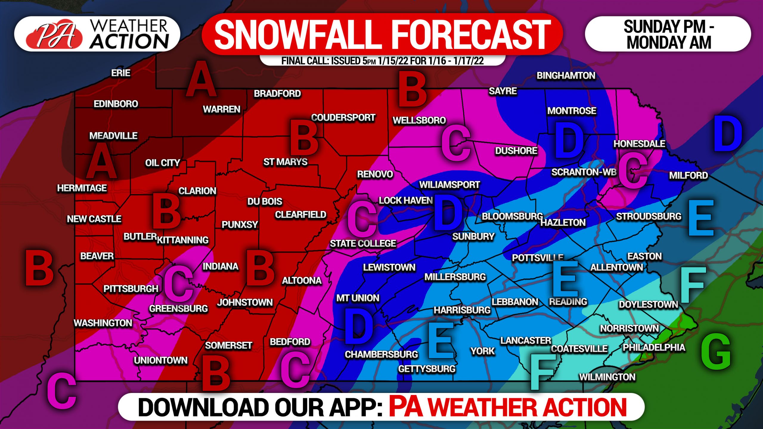
FINAL CALL SNOWFALL FORECAST FOR SUNDAY – MONDAY
Further details regarding timing and forecast variables are above.
Area A: Snowfall accumulation of 12 – 20″ expected. These locations will stay all snow, with a deformation band anticipated to setup over this region Monday Morning. Snowfall rates of up to 2-3″ per hour possible.
Area B: Snowfall accumulation of 8 – 12″ expected. These locations will stay nearly all snow, with short-lived pockets of sleet possible. Snowfall rates of up to 1-2″ per hour possible.
Area C: Snowfall accumulation of 6 – 8″ expected. Some sleet will mix in early Monday Morning. Snowfall rates of up to 1-2″ per hour possible.
Area D: Snowfall accumulation of 4 – 6″ expected. Snow to begin, then sleet and freezing rain, followed by plain rain for a few hours, then back to a brief period of snow mid-Monday Morning. Snowfall rates of up to 1-2″ per hour possible at the onset.
Area E: Snowfall accumulation of 2 – 4″ expected. Snow to start, followed by a changeover to sleet and freezing rain, and then rain by early Monday Morning. Perhaps ending as a brief period of snow by mid-Monday Morning.
Area F: Snowfall accumulation of 1 – 2″ expected. A brief period of moderate snow to start, followed by sleet and then mainly rain.
Area G: All rain expected.
This is a tough forecast due to the tight impact gradient as you can see by our seven different areas. We appreciate you sticking with us.
[social_warfare]


You must be logged in to post a comment.