
We are following two opportunities for winter weather in the coming five days, with the first being Sunday and the second on Wednesday. Sunday’s event will bring light impacts for most, with moderate impacts in parts of Northern PA. Wednesday’s storm may bring more widespread moderate impacts. For now, let’s cover Sunday.
Temperatures will be on either side of freezing Sunday afternoon, with mainly higher elevations above 1000 feet at or below 32 degrees. As a result, road impacts will be minimal in valleys, with slushy roadways possible in higher elevations.
Timing
Precipitation will push in Sunday afternoon from southwest to northeast. Snow will overspread most of the state by early Sunday evening, with the rain/snow line pushing north along I-81. Pittsburgh is a tough call, with rain likely south of the city, snow to the north, and a dividing line probably from the city and down to Latrobe. Heaviest snowfall rates are likely from State College to the Endless Mountains and into the Northern Poconos. Precipitation will exit the area late Sunday evening in the form of snow northwest of I-81, and rain southeast of I-81.
Below is future radar from the latest 3km (Hi-Res) NAM model. It’s a bit warmer than other guidance. Also, ignore the rain shown ahead of the snow Sunday afternoon, that’s just a flaw with the program.
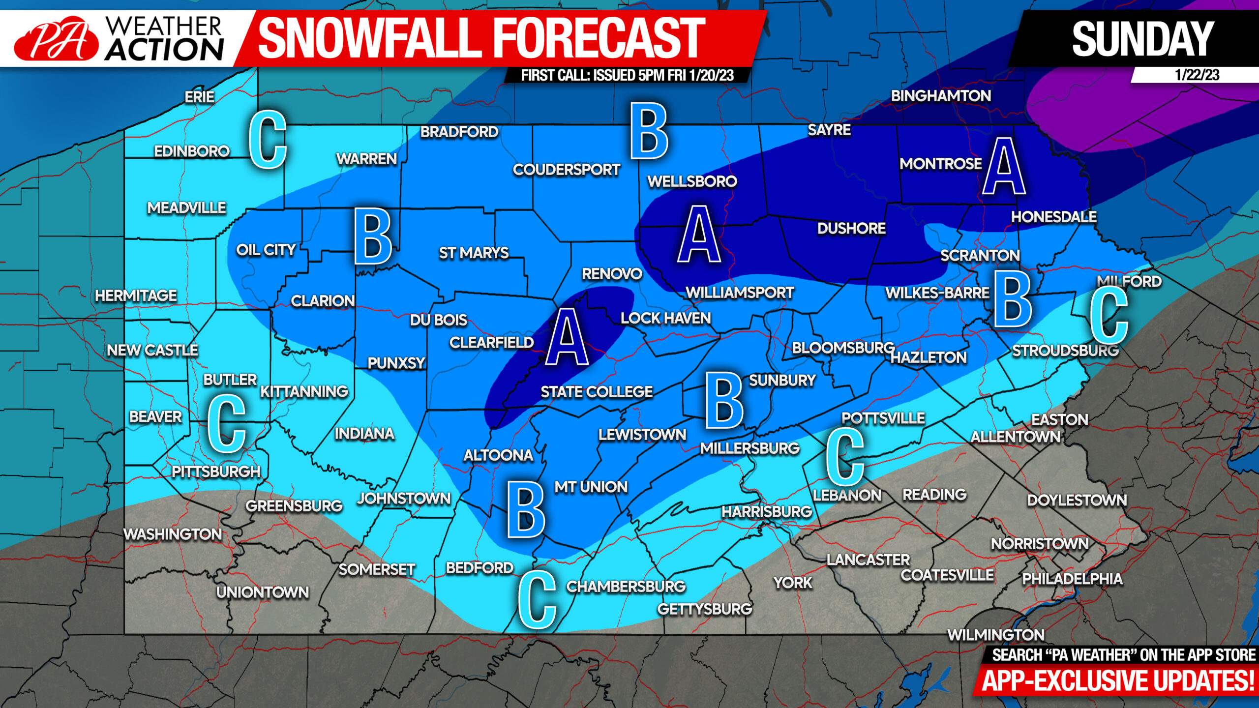
First Call Snowfall Forecast for Sunday
[fwdzoomer preset_name=”skin1″ image_name=”sun22″]
Area A: Snowfall accumulation of 3 – 5″ expected. A few slushy inches of snow may make travel difficult in higher elevations.
Area B: Snowfall accumulation of 2 – 3″ expected. Slippery travel possible in the mountains.
Area C: Snowfall accumulation of 1 – 2″ expected.
We will have a final call out for this storm Saturday evening. Like us on Facebook if you haven’t yet!
Get frequent model updates regarding trends and our thinking on upcoming significant weather well in advance, over on our app. There’s a free trial if you’d like to try it out in the coming week as we track the next storm. Just tap the banner below!


You must be logged in to post a comment.