
It’s nice to see you all again after we skipped forward to March for about a month. Winter finally will be making at least a short return, and surprisingly we may be cashing out on the brief cold air we will get. That is, if you enjoy snow.
We are watching two potential storms, but as we all know, things change with time. Sometimes very quickly, so let’s give the second threat time. All I’ll say about it now is that it’ll probably be a colder storm than the first one, and it would happen Jan 25-26 (next Wed-Thur).
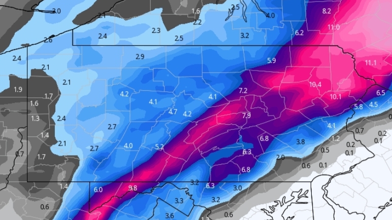
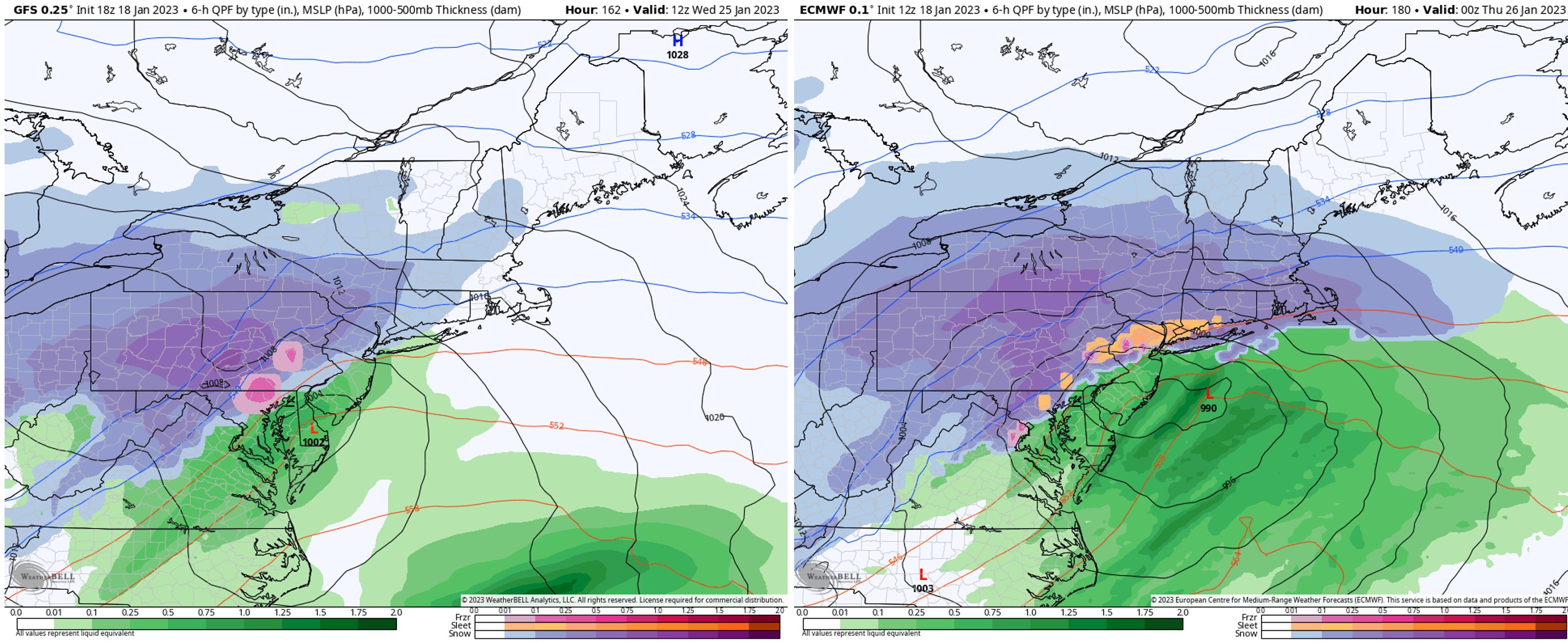
The first storm will come in Sunday evening and exit Monday morning. We are certain there will be a rain/snow mix line in play, likely in Southern and Eastern PA. But where that line sets up for much of the storm all depends on where the primary low pressure transfers to the coastal low. The longer the primary low is dominant and the farther north it gets in the Appalachians before transferring, the less snow and more rain there will be south of I-80.
The European model has a very early transfer, resulting in a stronger coastal storm that still rides over NJ, which causes Southeast PA to rain. The Canadian and GFS have the primary low hanging on as far north as WV, causing a late transfer and rain for most of the state. Below is a comparison of the American model (GFS) and the European model (ECMWF).
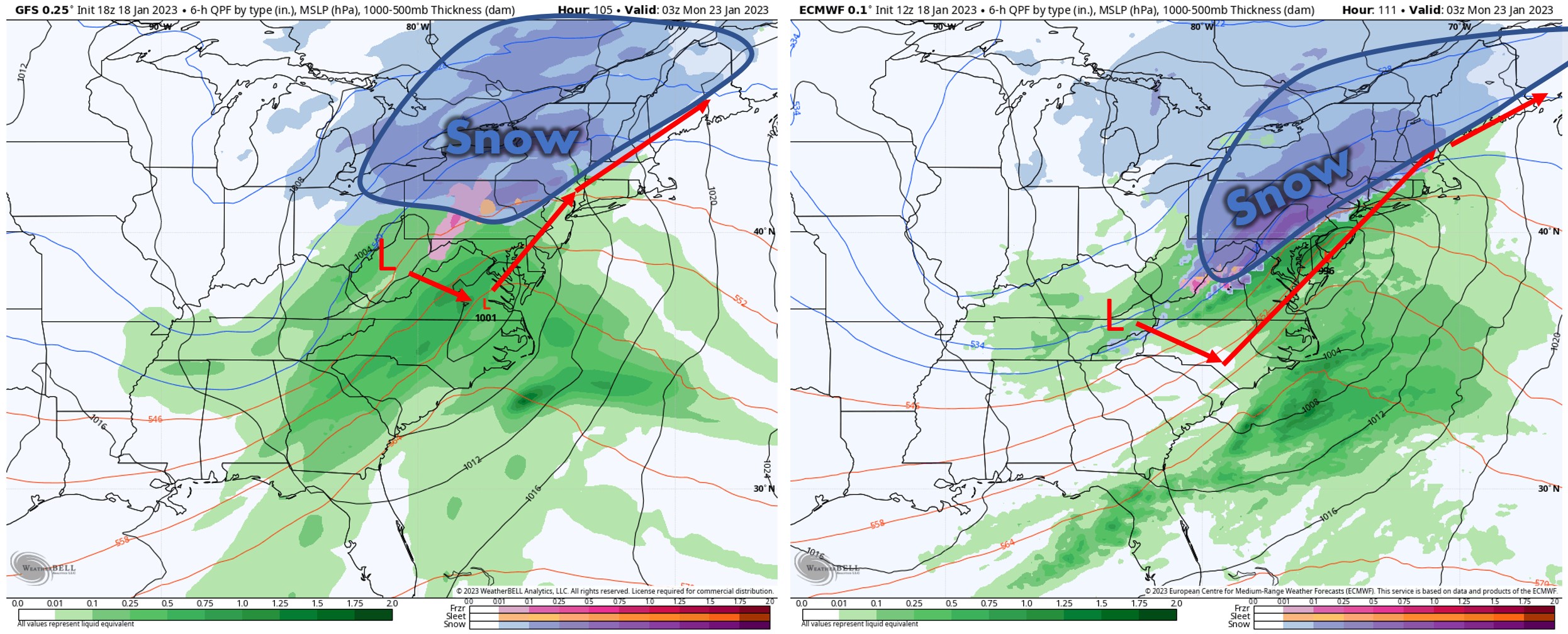
It’s a tough call and still practically a guess when it comes to which model will be correct. The lack of any decent high pressure supports the GFS and Canadian models, but then again they also have lower accuracy scores than the Euro model. I’d take a mix of the two, and budge the European model about 40 miles northwest with its rain/snow line. I think the Lehigh Valley will mix between rain and snow, and down through Harrisburg and Chambersburg as well.
I believe Southeast PA will see all rain out of this storm. On the flip side, I think the heaviest snow amounts will be found in Northeast PA, from the Endless Mountains to the Northern Poconos. The ceiling for snowfall amounts is around 6-10″. This is largely due to surface temperatures being very warm for this time of year, disallowing ratios to increase snow amounts in the usual fluffy snow events you’d expect in late January. This snow will be slushy and difficult to shovel, with temperatures on either side of 32 degrees as the snow is falling. High elevations will have the benefit there, as the difference between 34 and 30 degrees is massive when it comes to snow accumulation.
It’s still too far out to share model snow maps publicly, because of all the misinterpretation that happens. Models will continue to experience sizeable shifts through Friday. If you want to stay on top of the latest trends and view articles more in-depth with snow maps and lots of other graphics, check out our Updates section in our app. We do updates twice a day there. Tap below to head over there.

As stated, we’re watching two storms. The second storm has loads of question marks around it, one of them being if the storm even occurs, and another being how significant it is.
Models have been floating around a significant to even major storm, but we’ve seen this many times before a week out, and there’s not exactly loads of support for a big storm with this pattern. Below is a comparison of the American model (GFS) and the European model (ECMWF) for the second storm.
I think the rain/snow mix line will be in play in Southeast PA, and I think heaviest snowfall amounts will be in the Appalachian mountains. That’s if the storm happens. Let’s take it easy on this one though and keep our focus on the first storm!
Stay tuned for more updates in the coming days!
Be sure to share this update with any snow-starved friends and family!
[social_warfare]

You must be logged in to post a comment.