
We are tracking yet another winter storm that will impact the area on Wednesday. This storm will continue the trend this winter in regards to precipitation type. Many areas will start off as a period of snow, potentially heavy snow, before transitioning to a period of sleet and freezing rain, and then ending as plain rain in some areas.
Snow will begin to move into the picture Wednesday morning across our southwest counties. Below is a look at our future radar valid for 7:00 AM Wednesday morning:
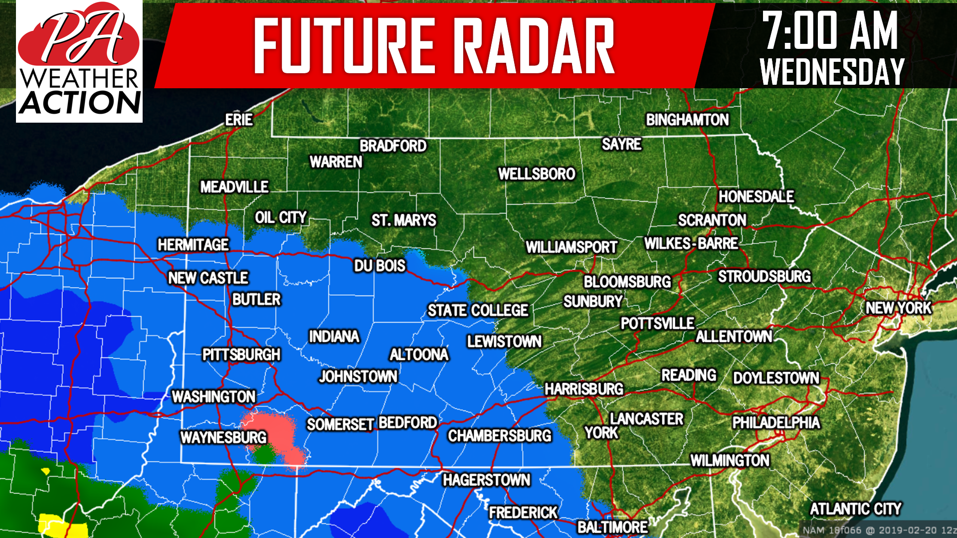 When the snow is falling, it will come down at a moderate to heavy clip. 1 to 2 inch per hour snow rates are certain possible, especially across the Laurel Highland and parts of South-Central Pennsylvania. We are looking at a 4 to 6 hour period of snowfall for just about everyone before the transition to mixed precipitation. The combination of several hours of snow and rates 1 to 2 inches per hour will lead to significant accumulations across these areas. Taking a look at the future radar for 1:00 PM Wednesday afternoon, the snow has expanded across most of the state. Areas in Western and parts of Southern Pennsylvania have begun to transition to sleet and freezing rain:
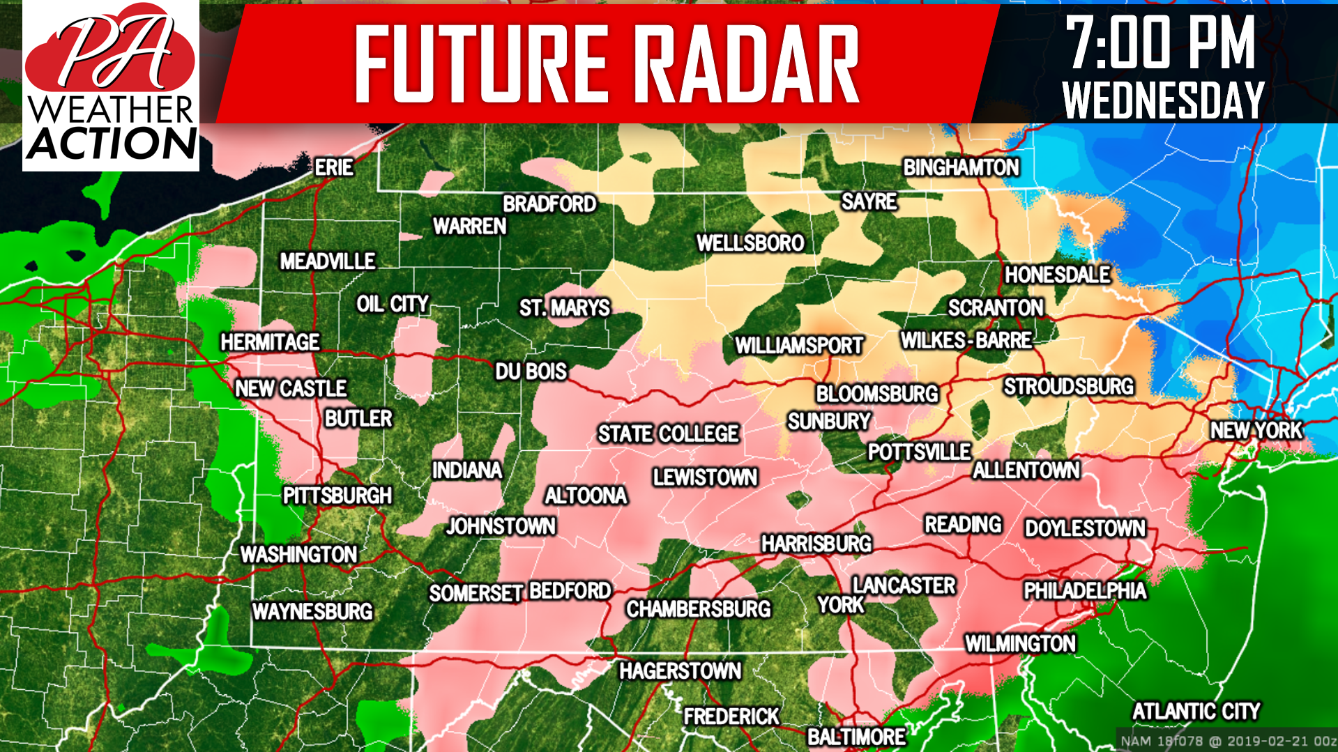
 While the morning rush hour should not be impacted for a lot of us, the evening rush hour will be heavily impacted across the state between the snow, sleet, and freezing rain. By 7:00 PM Wednesday evening, most areas have changed over to sleet and freezing rain. The ice will compact on top of whatever snow has fallen, leading to more issues going into the nighttime hours Wednesday:
 The storm system will begin to wrap up as we head into the early morning hours Thursday.
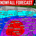
FIRST LOOK AT WEDNESDAY’S WINTER STORM POTENTIAL:
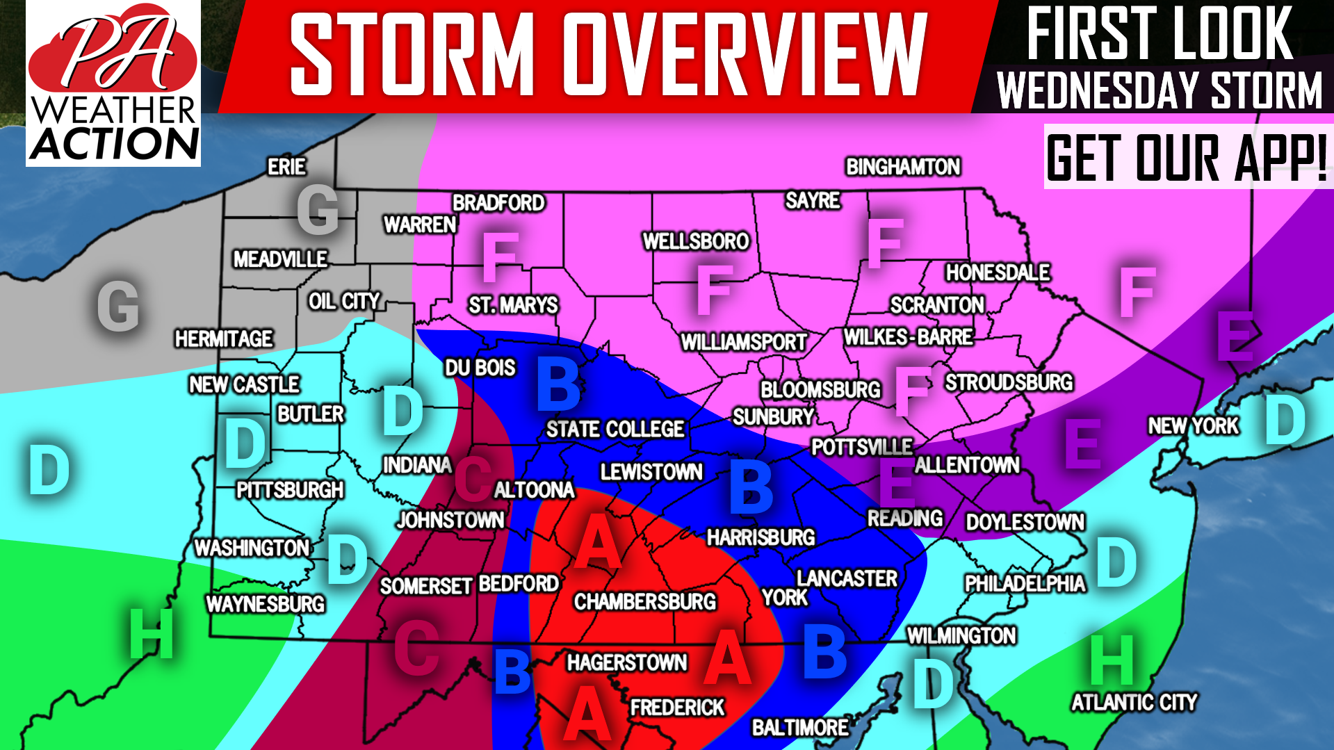
You may have noticed the map is slightly more complicated than usual. We are going for a more location-specific forecast, with hopes to be more accurate locally.
Area A: This area is currently expected to feel the greatest impacts from this storm. A period of very heavy snow, with rates of 1-2″ an hour is possible Wednesday Morning. A changeover to sleet and freezing rain will occur, with the threat of moderate ice accumulation on top of moderate to significant snow accumulation. Wednesday is not at all looking good travel-wise at this point.
Area B: Similar to above, this area will likely see a several hour thump of snow before changing to sleet and freezing rain. Moderate snow accumulation possible, followed by moderate ice accumulation especially north of Harrisburg and Bedford.
Area C: After a couple hours of heavy snow, this area will change to sleet, then freezing rain. Light to moderate snow accumulation possible, followed by significant ice accumulation.
Area D: The storm will likely begin with a short period of heavy snow. A quick changeover to sleet is then likely to occur, leading to plain rain. Some suburbs north of Philadelphia may stay below 32 degrees, slightly longer, leading to light ice accumulation on top of light snow accumulation.
Area E: A period of moderate snow may impact the area around noon Wednesday, before transitioning to an extended period of sleet and freezing rain. Light to moderate snow accumulation possible followed by moderate ice accumulation.
Area F: Light to moderate snow early Wednesday Afternoon will quickly change to light sleet and freezing rain by the evening. Light snow accumulation possible, followed by light ice accumulation.
Area G: Little in the way of impacts is expected to be felt here. Light snow Wednesday Afternoon will likely transition to plain rain by the evening.
Area H: Brief snow and sleet is likely to transition to rain.
Remember, nothing is locked in yet. We will have our First Call Snow & Ice Forecast out Monday Evening, with more details on amounts and timing. To receive that as well as your local hourly & daily forecast, radar and more, download our free app >>> PA Weather App!
Be sure to share the news of yet another wintry mess with your friends and family using the button below, stay tuned!
You must be logged in to post a comment.