
6:00 PM Tuesday Update: First Call Snowfall Forecast for Thursday – Friday Wintry Mix
Our first widespread snow threat of the season is looking more and more likely Thursday into Friday. Model data is slowly coming into agreement regarding the specific area targeted by this snow threat. For now, that area looks to be mainly the northern half of the state. For the many of you who live in southern PA, despite probably “missing out” on this, it won’t be long. We’re entering into a very persistent pattern featuring well below average temperatures and an active storm track. This pattern looks to continue at least for the next several weeks, so there will be several more chances.
For now, let’s get into this storm. A disturbance moving across the plains will make its way east, likely spawning a weak low pressure system in Maryland by late Thursday night. From there, the storm is likely to strengthen as the system moves northeast up the New England coast. A high pressure to the northwest will supply limited cold air.
STORM TIMING
Light to moderate precipitation is expected to move into western PA mid-evening Thursday. The rain/snow line looks to setup from Butler to Coudersport, with areas north of that seeing snow and south seeing rain. By late Thursday evening, light to moderate snow will reach northeast PA, with the rain/snow line setting up from Williamsport to Scranton, with north of it snow, and rain south. The rain/snow line is expected to slowly move south and east as Thursday night progresses.
Heading into early Friday morning, much of western PA should switch over to all snow. At the same time, snow is expected to intensify in northeast PA, as the rain/snow line drops south to around Bloomsburg to Mount Pocono. By sunrise Friday morning, the snow will be over in western PA, and beginning to exit northeast PA.
SNOWFALL POTENTIAL MAP
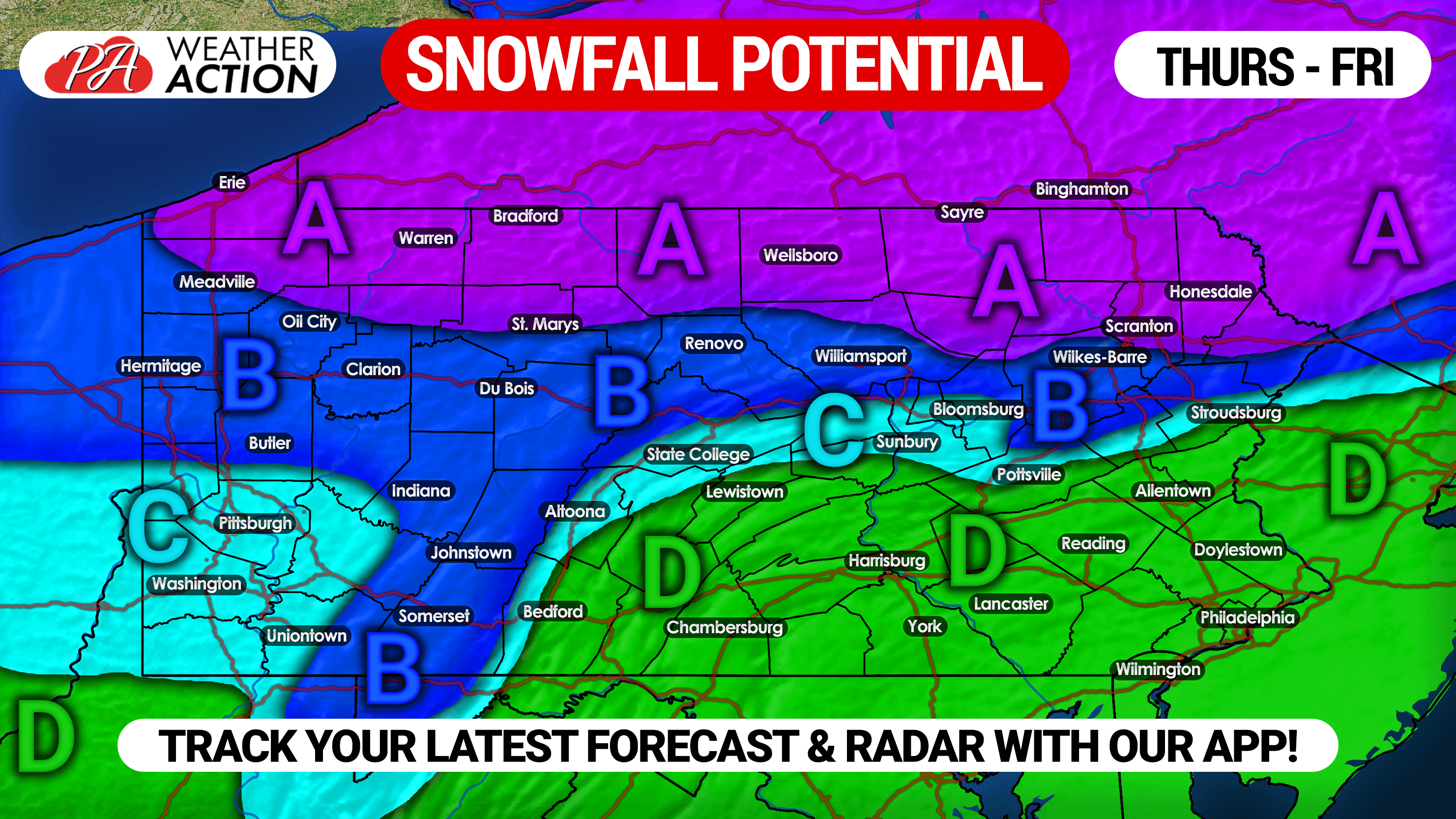
Area A: We expect this area to see all snow, and several inches of snow are possible.
Area B: This region is currently expected to be near the rain/snow line. Some locations may start off as rain, before transitioning to snow. For now, light snowfall accumulations possible.
Area C: Locations within this area are anticipated to begin as rain, and change to snow by the end of the storm. Very minor accumulations possible.
Area D: We are pretty confident this area will see all rain. The high pressure placement is too far west, and temperatures at the surface will be in the low 40s during the event.
Don’t forget to share this forecast with friends and family using the share button below!
Track the storm with your local forecast, interactive radar, and more with our free app >>> Weather Action App
We will have morning video updates discussing recent model trends and impacts for the entire northeast >>> YouTube Channel
You must be logged in to post a comment.