
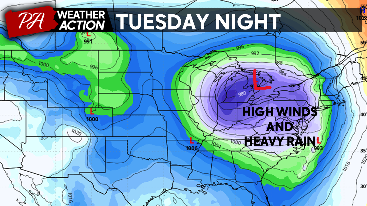
Good Evening Everyone! We are currently in a very active weather pattern across the Eastern US, with about a 48-72 hour return period between storms. With this, we are tracking a very powerful storm that is set to bring significant impacts to our region tomorrow. A strong low-pressure system will move NE into the Great Lakes region tomorrow, bringing wide-ranging impacts to the entire Eastern US. While locations in the midwest will experience blizzard conditions, locally, heavy rain and high winds will create significant problems across the region tomorrow! Continue reading for more!
Tuesday
Tuesday morning will start off quiet, the calm before the storm, if you will. Expect cloudy skies and temperatures in the low-30s region-wide Tuesday morning. Southerly winds will quickly draw warm air into the region before precipitation arrives, ensuring that precipitation will fall as rain region-wide. Expect temperatures to rise into the 40s by noontime.
Rainfall
Rainfall will overspread the region between 11 am and 1 pm tomorrow from west to east. Moderate rainfall will continue through the mid-afternoon across the region. Moderate to heavy rainfall will move into the region by the evening, increasing the threat of flash flooding, especially across urban areas. Heavy rainfall will continue into the overnight hours. Temperatures will become increasingly mild into the overnight hours. Most locations will warm into the mid to upper 50s overnight!
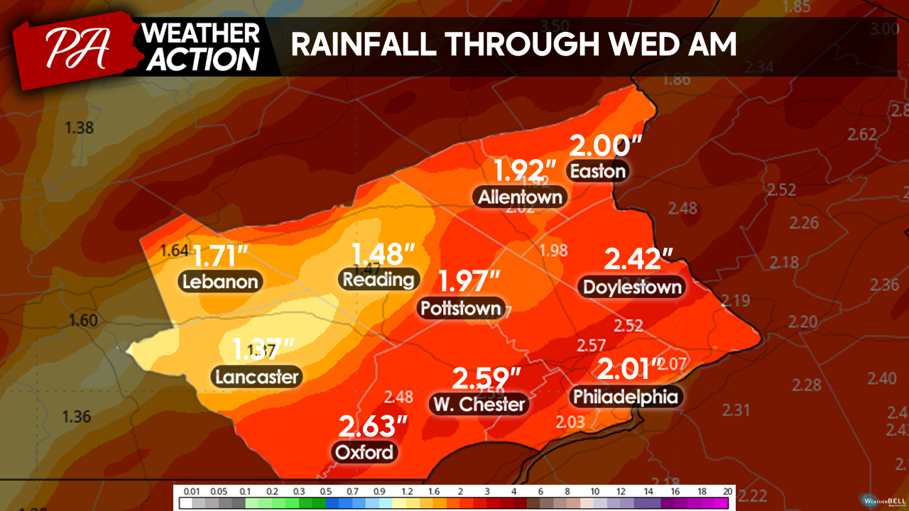
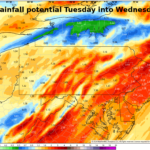
Here is a model estimate of rainfall totals across the region. I expect a widespread 1.5 – 3 inches of rain to fall across the region. Heavier bands of precipitation may push rainfall totals over 3 inches locally.
Additionally, the flood threat will be exacerbated by our saturated soils from previous rainfall events over the past few weeks and a melting snowpack from the weekend storm. This will likely lead to river flooding across the region. I expect many streams and rivers to swell and overflow their banks region-wide tomorrow. If you are in a flood zone, be on high alert!
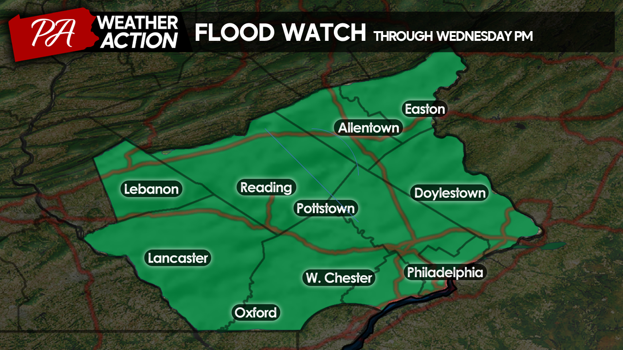
The National Weather Service has issued a flood watch until Wednesday evening for the entire region.
 Winds
Winds
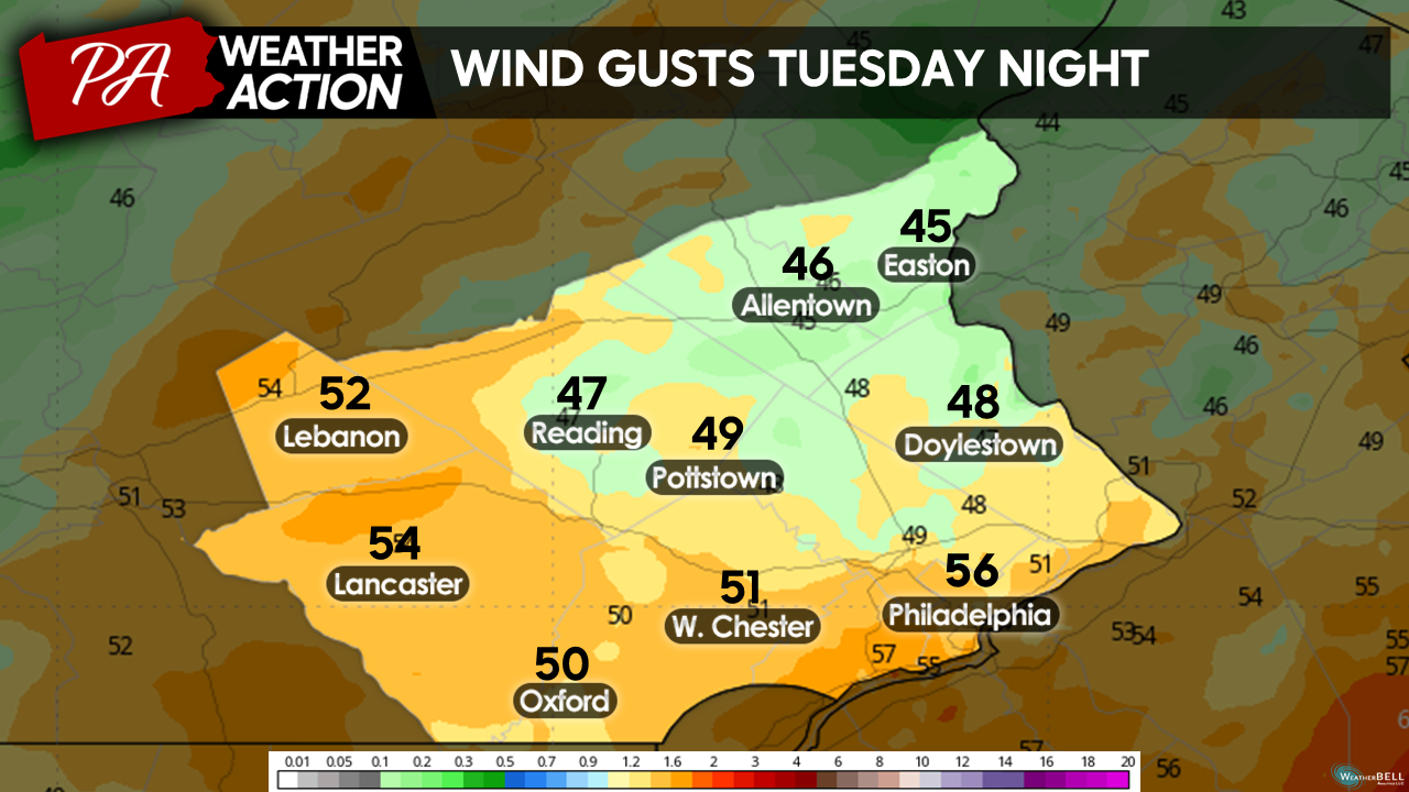
Winds will begin to noticeably increase tomorrow afternoon as precipitation moves in, peaking around midnight Tuesday night. I expect widespread sustained winds of 20 – 40 mph, with wind gusts up to 60mph likely!
Given our saturated soils and high winds, tree damage is a significant concern with this system. This will likely result in power outages across the area.
Here is a model projection of wind gusts across the region Tuesday Night, actual wind gusts will vary from these numbers.
Be prepared for power outages to possibly last for an extended period. As mentioned, this is a massive system with wind concerns for the entire Eastern US. Power crews will likely be strained after the storm exits.
The National Weather Service has issued wind advisories region-wide. 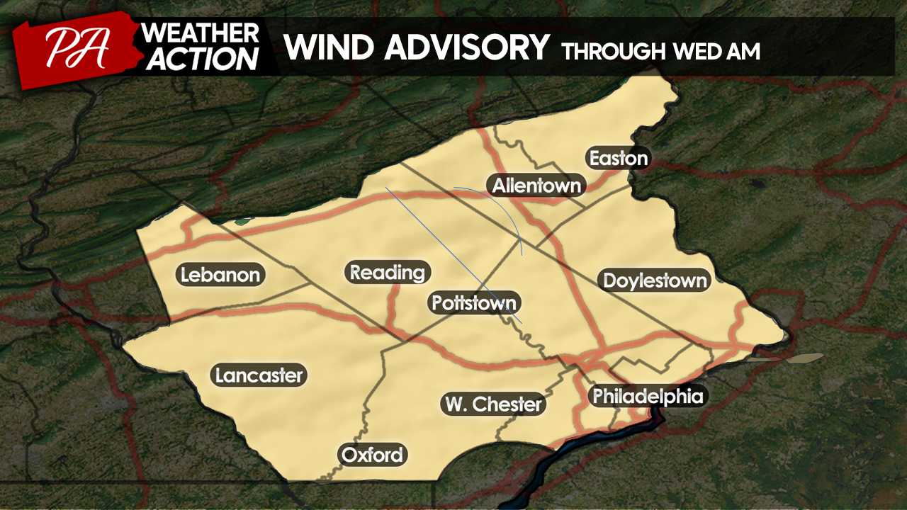
Coastal Flooding
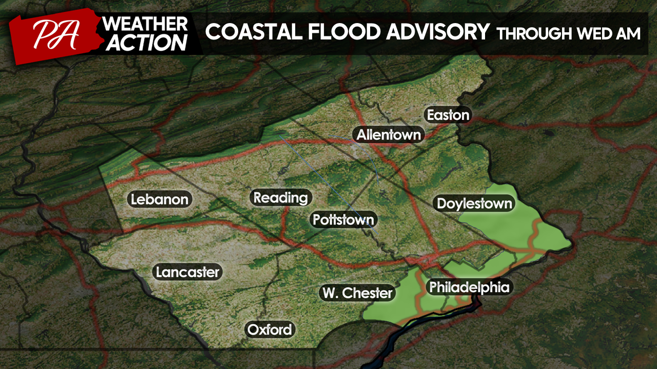
Additionally, coastal flooding will be a concern for southeastern areas located along the Delaware River. 1-3 feet of water rise is possible Tuesday night along low-lying tidal zones.
For this reason, the National Weather Service has issued coastal flood warnings for Delaware, Philadelphia, and Southern Bucks counties.
Rainfall will clear the region in the predawn hours Wednesday morning. Winds will shift from the SE to the NW as the storm departs; however, wind gusts will remain high (25 – 40 mph) throughout the day on Wednesday.
Again, this storm is very significant from a meteorological standpoint and should not be overlooked or taken as “hype”. Tomorrow’s evening commute will be heavily impacted. Please avoid travel if possible Tuesday Afternoon, and Wednesday Morning as flooding and wind damage will make travel especially dangerous.
Looking Ahead:
We are looking at relatively quiet weather for the remainder of the workweek with seasonable temperatures. However, we are unfortunately looking at another storm, very similar to tomorrow’s storm, impacting the region Friday night into Saturday. This will likely be another high-impact event and will only exacerbate problems generated by tomorrow’s storm! We are in a very active period of weather so make sure you are keeping up to date with the forecasts.
Tomorrow, I will post periodic updates on the storm, time permitting! If you have any questions, comments, or concerns with the forecast, please let me know and be weather-aware tomorrow!
You must be logged in to post a comment.