
Good evening, everyone! We are currently tracking a powerful low-pressure system set to move through the region tomorrow into Monday. Very heavy rainfall, high winds, and even some potential backend snow are on the table, making for a weather mess to close the weekend. Our storm system is developing along a preexisting cold front in the Tennesse Valley. This is currently triggering a significant severe weather outbreak across this region, which is indicative of the dynamic strength of the developing system. 
By tomorrow morning, extensive cloud cover will be in place over the region. Warm air will surge northward ahead of our system, setting the stage for a mild day on Sunday, with temperatures rising into the 50s and 60s.
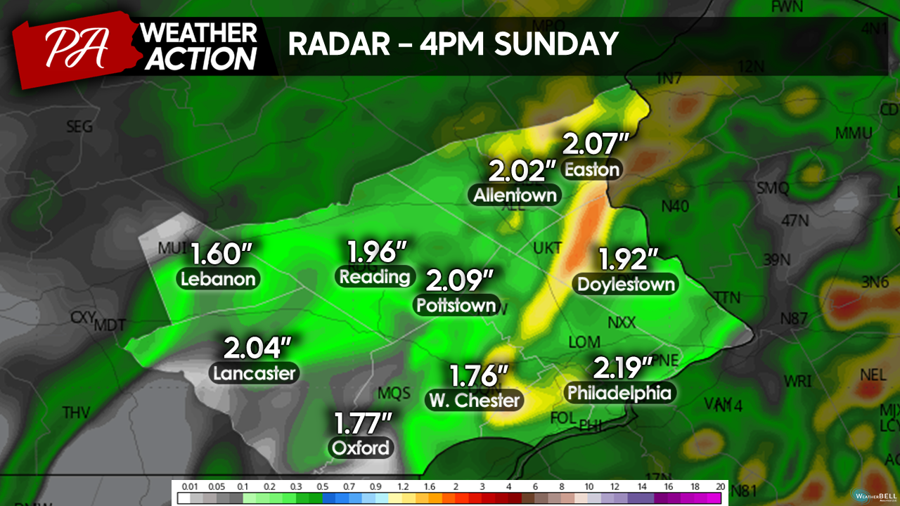
 Rainfall will begin to move in around lunchtime and will be heavy at times from the start. Into the afternoon, rounds of showers and thunderstorms will continue to move through the region, bringing periods of heavy rain. Additionally, the dynamics of this system will allow very stong winds to develop just above the surface. Periods of heavy rain may transport these winds down to the surface, setting the stage for potentially damaging wind gusts. I expect sustained winds to range from 20-30mph, with a few gusts up to 50mph in the strongest bursts.
At this point, it would be advisable to make sure any outdoor items, including holiday decorations, are secured or brought inside ahead of the storm system, as wind gusts could toss these items around. The potential also exists for isolated power outages, especially in the higher elevations and eastern portions of our region. Be mindful that these winds could bring down branches and maybe even a few weak trees!
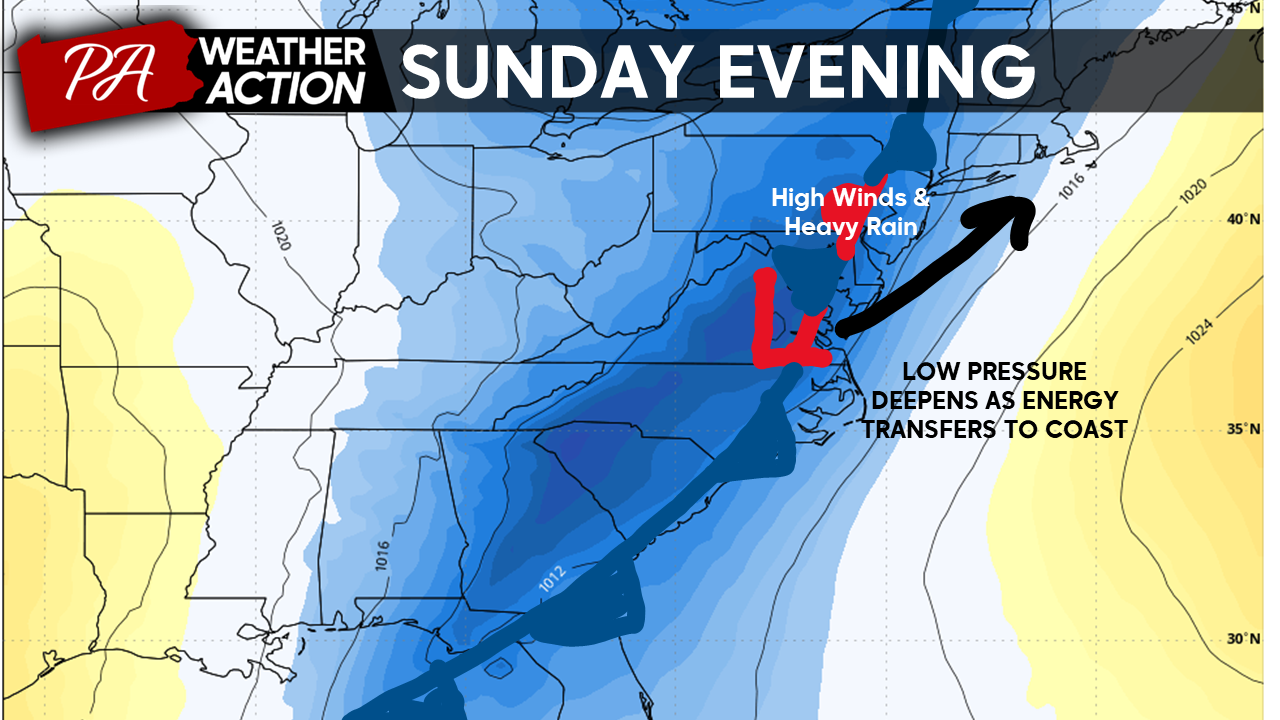
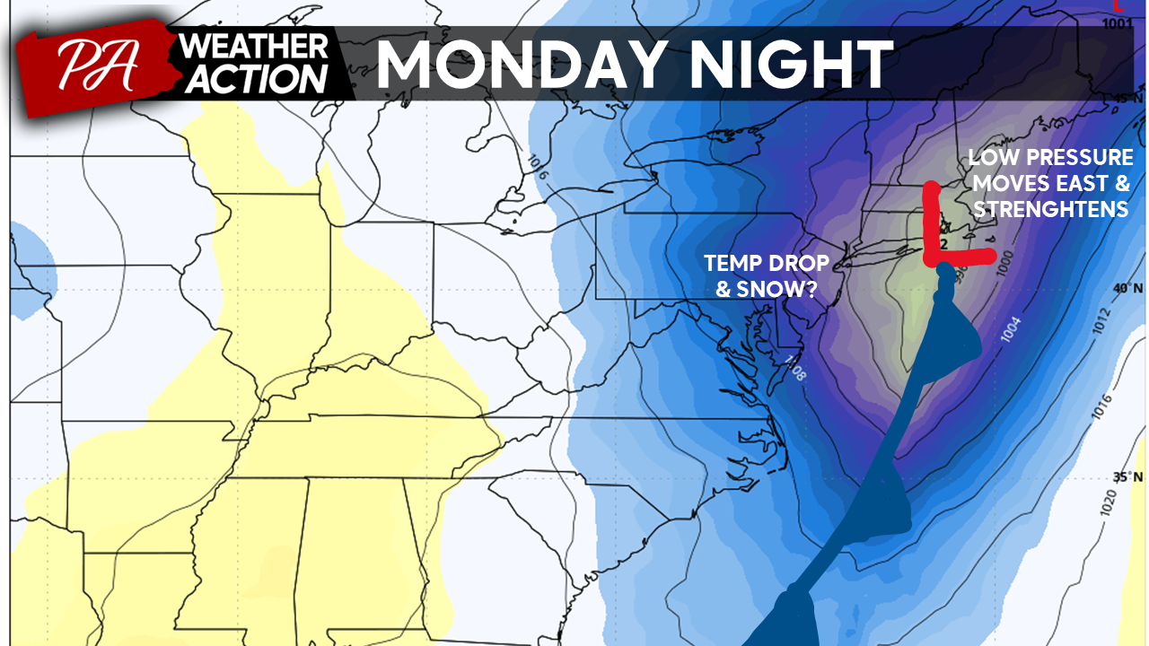
Rainfall will continue into the overnight hours on Sunday as our low-pressure system moves off the coast. On the back side of our system, winds will shift from the South to the Northwest, ushering in a rapid drop in temperatures. Overnight Sunday winds will remain gusty and rainfall heavy as temperatures will crash from the 60s to the 30s by daybreak Monday. This drop off in temperatures will allow some areas to change over from rain to snow Sunday night.
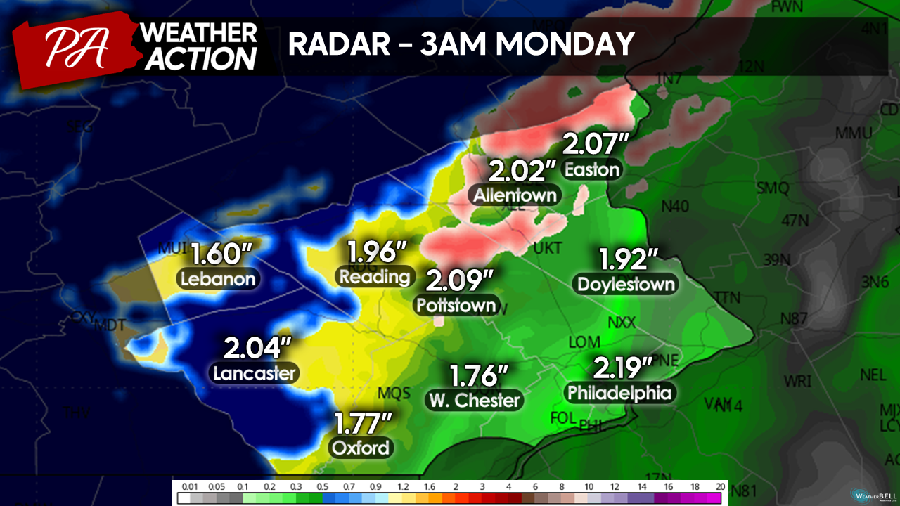
A period of moderate snowfall is possible, especially for the Western and Northern portions of our region. However, considering temperatures will have just fallen from the 60s and surface temperatures will remain just above freezing, snow will be slow to accumulate, if at all. Snowfall accumulations should stay below an inch across the region. However, higher elevations in Lebanon and Berks counties have the highest chance of seeing accumulations exceeding 1 inch. The snow side of this system is where the highest level of uncertainty still remains, while this is my best prediction of snow as of now, I will update if I see any significant changes transpire over the next 24 hours.
Precipitation should begin to clear the region from west to east Monday morning, with the entire region turning dry by lunchtime. Winds will also slacken off Monday morning.

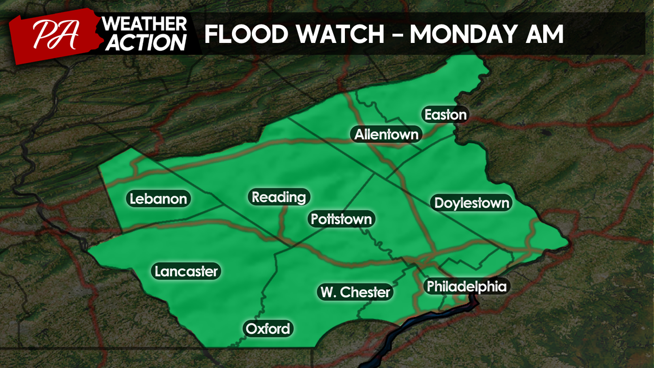
Heavy rain and high winds remain the primary concern from this system. Training thunderstorms Sunday evening and overnight will create the potential for localized urban and small-stream flooding. For this reason, the National Weather Service has issued flood advisories for the entire region.
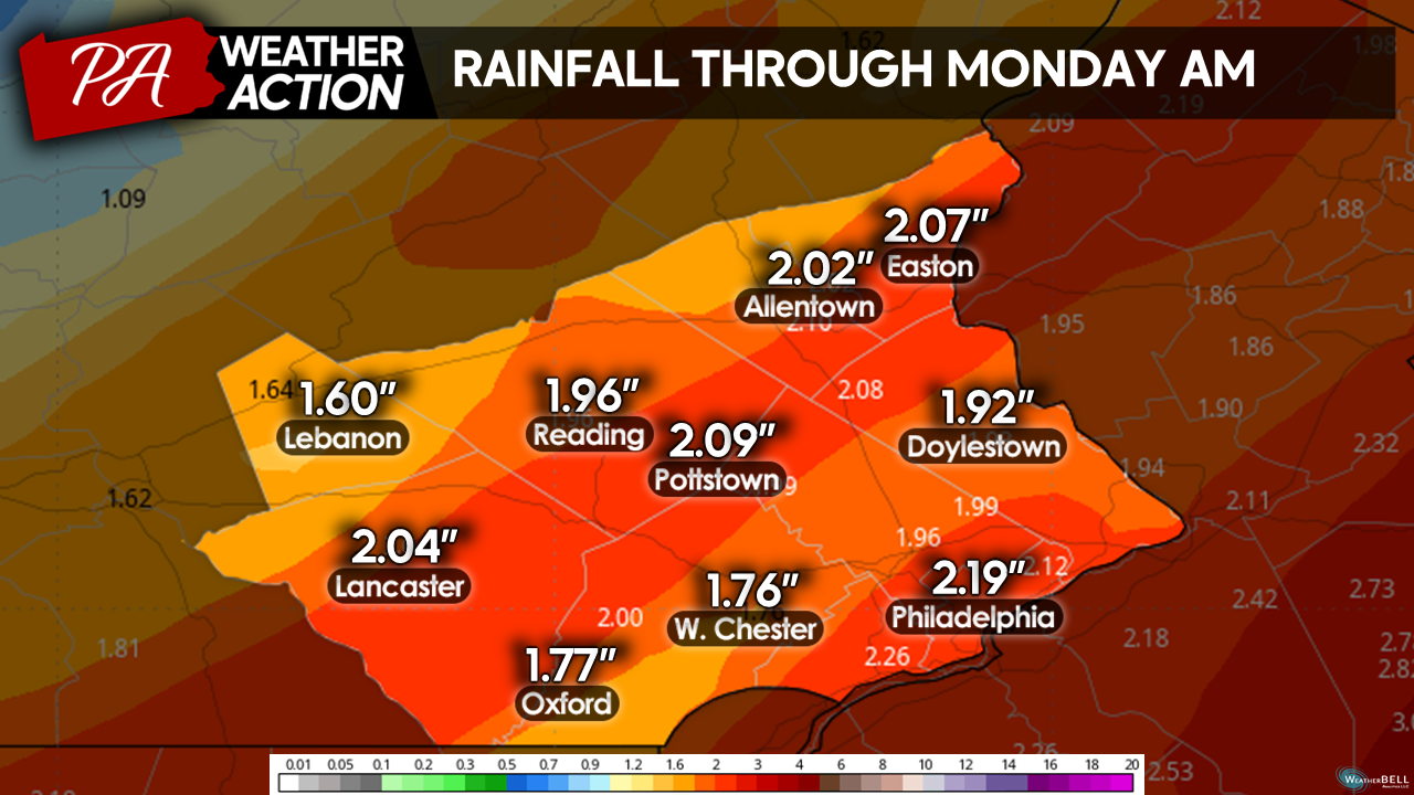
Overall, I expect a general 1.5-2.5 inches of rain to fall across the entire region. However, localized areas may see rainfall totals exceed the 3-inch mark.
Ultimately, this storm system is set to create a mess of conditions over the region to close out the weekend. It would be best to plan on avoiding travel from Sunday afternoon to Monday morning while this system is moving. On a more positive note, the weather looks to turn quiet as we head into next week. As always, if you have any questions or comments regarding the forecast, feel free to let me know!
-Michael Woytowiez.
You must be logged in to post a comment.