
Light rain and mix will afflict the area tonight through sunrise Friday, with some light snow accumulations possible in the higher elevations.
FRIDAY
Precipitation will end early in the morning, with cloudy conditions for the rest of the day along with mild conditions. Most of the day will feature light wind, although gusty north wind will push a brief blast of cold air into the area starting Friday evening.

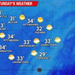
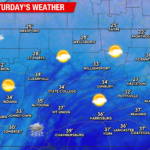
SATURDAY
Saturday will bring a brief reminder that we have yet to reach the Spring Equinox, with temperatures remaining in the 20s for most locations along with blustery NW wind gusting to 30 mph. There could be a few snow flurries but the day will be mostly dry.

SUNDAY
After a cold start with widespread teens, the surface high responsible for this brief wintry air will slide to our east and begin circulating milder air into the area with temperatures climbing to slightly above-normal levels.

BEYOND SUNDAY
Next week (Feb 26-March 1) will feature increasingly balmy weather along with cloudy conditions and a persistent threat of light showers. Temperatures will eventually reach as much as 20 F above normal by mid-late week ahead of a cold front that could deliver a soaking rain late in the week (most-likely Thursday).
You must be logged in to post a comment.