If anything, May is a time for transition to summer, and it can be a bit rough in the transition. However, farmers and growers will welcome any rain they can get.
SEVERE STORMS POSSIBLE THURSDAY
Thursday will be hot with widespread highs in the upper 80s and even low 90s for some perhaps in eastern NC and SC. We mentioned this on our fb page as the “hottest day of the week.”
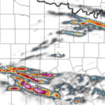
The SPC currently has marginal 1/5 chance of severe storms in the dark green. However, any storm that develops could have damaging winds and hail, and even a random spin-up.
Strong to severe storms will be across NC for the most part, however the northern corner of SC could also be affected. This looks like most of the severe activity will be limited to inland, however the northeast corner of NC could still see severe.
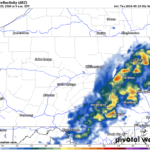
HIGH RESOLUTION FUTURE RADAR FOR THURSDAY
Timing: in the evening around 6pm or so, a line of storms moves out of northwest NC and heads east. This line could be a bad one, with trees and power lines coming down and even some hail damage in spots.
However, this looks more like a widespread wind event. There could be a swath of damage if this line can really get going.

FRIDAY AND THE START OF THE HOLIDAY WEEKEND
Friday will also be a hot day, in fact, most of the Holiday Weekend will be. Friday’s futurecast radar looks like storms could develop in late-afternoon and evening hours, and the NC coast could see some strong storms.
However, widespread severe is not expected on Friday. Just hot. with the 7-8pm future radar below:

SATURDAY

Saturday a disturbance moving close by offshore could spark showers and storms in eastern NC. This area of rain might not get going until the late afternoon hours, after the atmosphere has had a chance to heat up.
But nonetheless, these could be some cookout killers especially along the coast. These folks could be kept inside on Saturday.
Storms could happen anywhere, so be sure to have inside plans available on Saturday. Storms will form wherever they want, especially when it’s hot.

SUNDAY
Sunday does not look to be as quite of an active day as Saturday, however storms are still possible. NW NC and along the coast, and even NE NC could be under the gun for more storms and rain. However, this is the most settled day so far in the upcoming weekend.

MEMORIAL DAY
Monday remember those who did not come home as we take time to reflect upon the true meaning. Any get togethers should be good to go, with storm activity once again only rolling in later in the afternoon.
This is the kind of pattern taking shape for the summer, where you may get a storm or rain, and the next zip code over is completely dry.

Keep checking right here on Carolina Weather Authority for updates on travel and outdoor conditions heading into the major holiday!