
Good Evening Everyone! We are less than 12 hours out from our snowstorm set to impact the region tomorrow. Currently, a precursor system is bringing scattered snow showers across the area. However, the lower levels of our atmosphere remain very dry, meaning that much of the snow is evaporating before reaching the ground. These precursor snow showers are helping to moisten our environment before the arrival of the main event early tomorrow morning!
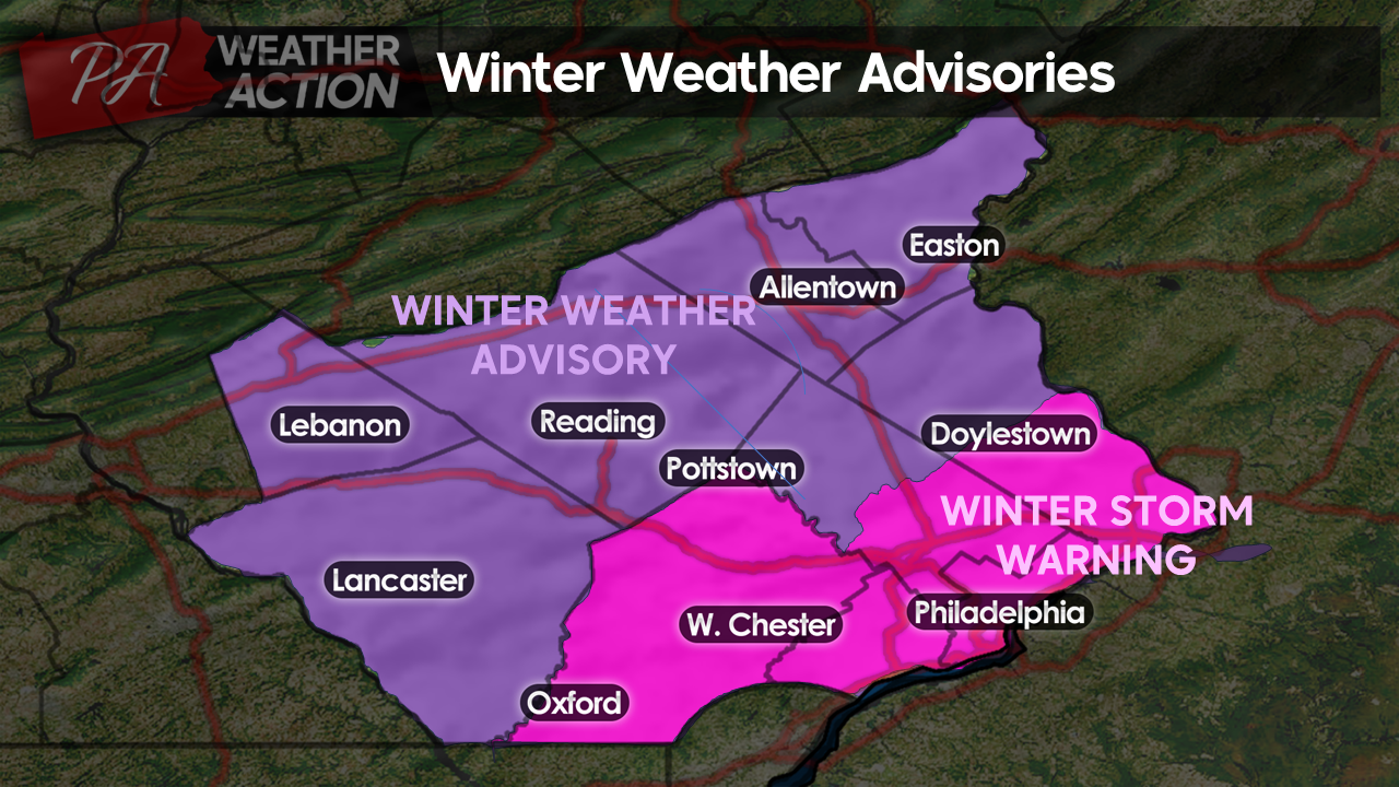
The National Weather Service has now issued Winter Storm Warnings for Chester, Delaware, Philadelphia, Southern Montgomery, and Southern Bucks counties! Winter Weather Advisories remain in effect for the remainder of the region.
 Here is an updated look at timing, totals, and impacts:
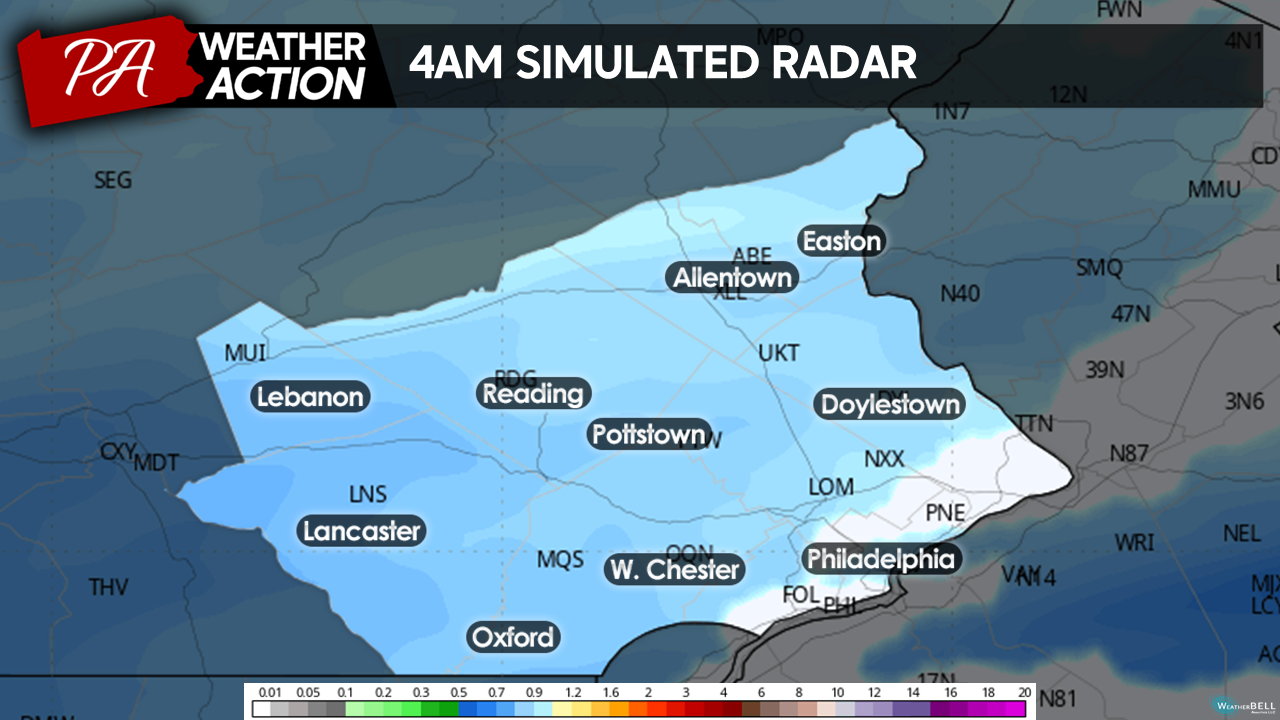
Light snow will overspread the region from 3 am to 5 am from West to East. Temperatures will be in the mid-20s, meaning that snow will accumulate from the onset. If you have to commute tomorrow morning, the earlier you can get out, the better, as conditions will worsen as snowfall rates increase later into the morning. Regardless, plan for extra time in your morning commute and watch for slick spots!
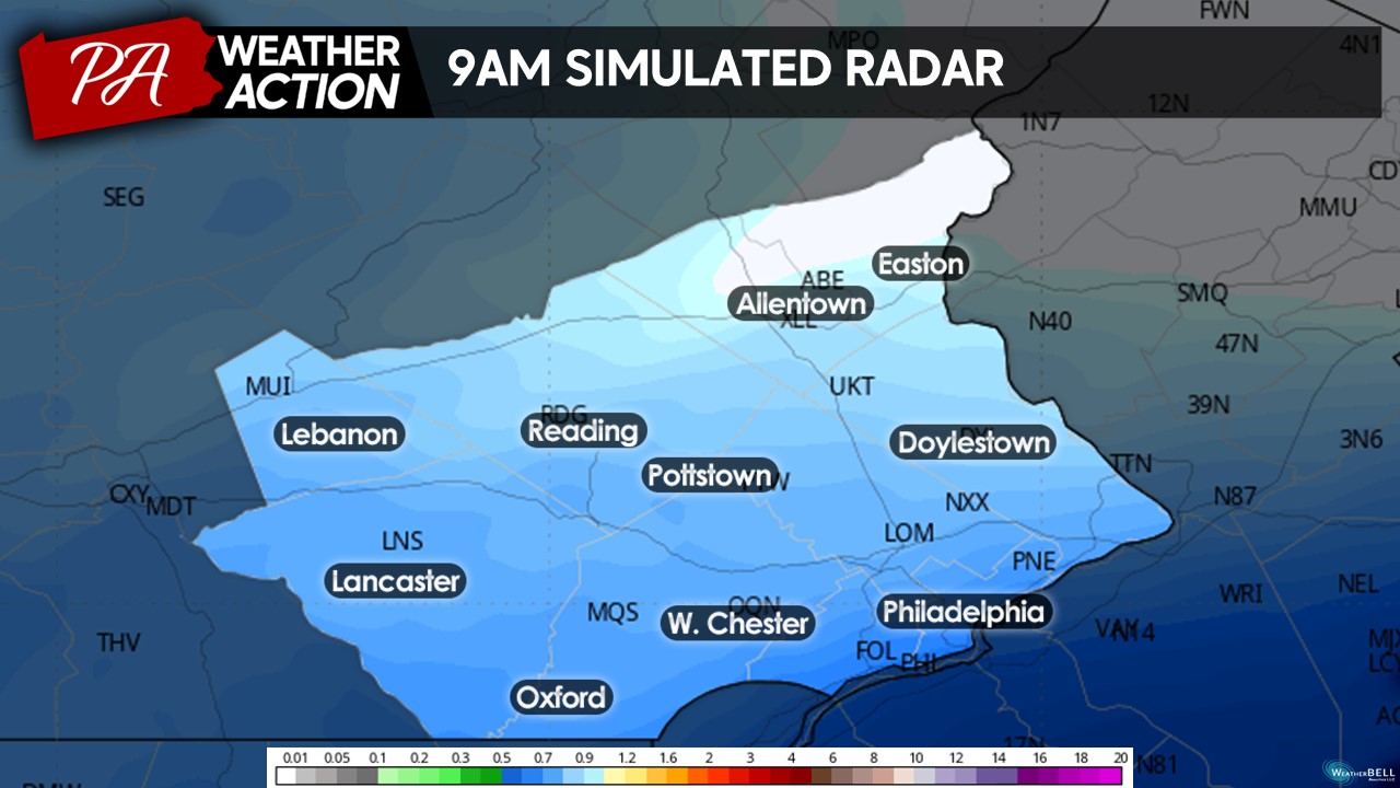
By 9 am, moderate snowfall will overspread the southern portions of our region, with light snow continuing across the rest of the region. The latest model guidance suggests that an enhanced area of frontogenesis (lifting) in the southern portions of our region will increase precipitation rates across this area. This will create a period of moderate-heavy snowfall across the southern tier from the late morning through the afternoon.
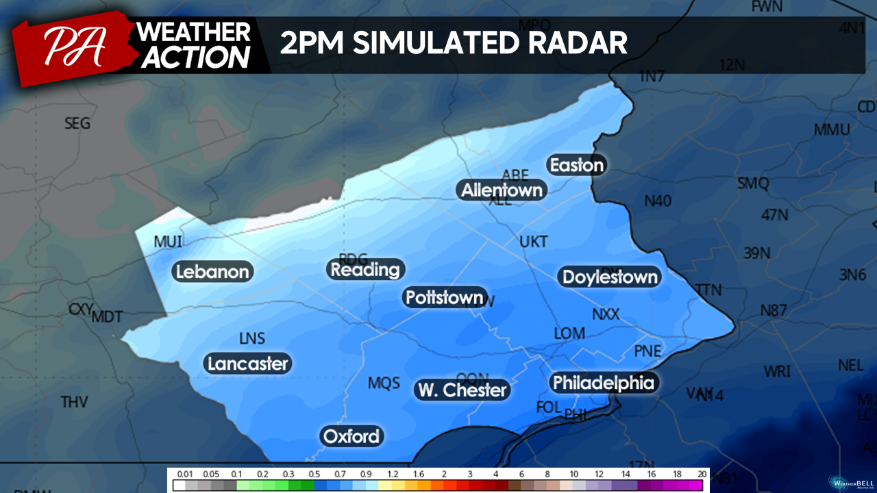
By 2 pm, Moderate – Heavy snow will continue across southeastern areas, with Light – Moderate snow continuing elsewhere. I expect the most adverse condtions between 10 am – 3 pm tomorrow. Travel is not advisable during this time. If you must travel, plan for extra time, as roadways will likely become snow-covered.
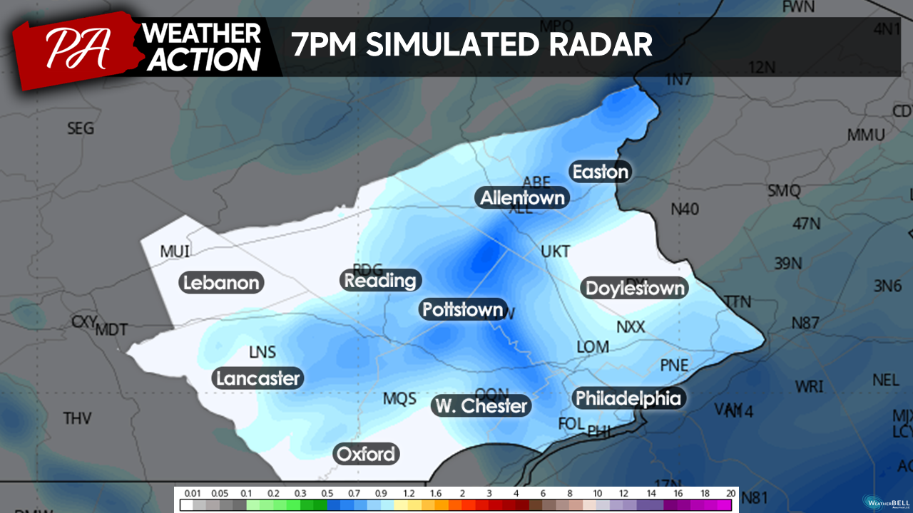
Snow will taper off through the late afternoon an into the evening from NW – SE. Although precipitation will be lightening up during the evening commute, we have just concluded the heaviest part of the storm, meaning roads will be messy! Lingering snow showers and squalls should clear the entire region by 9 pm tomorrow.
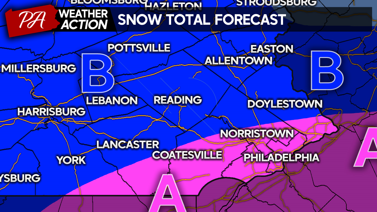
ZONE A: 4″ – 6″+ Moderate-Heavy Snow. Moderate-heavy snow will create a swath of 4″-6″ across SE portions of our region. Expect school cancelations, airport delays and cancelations, and hazardous travel conditions throughout the day tomorrow. I include the + as I think the threat of greater frontogenesis might push some locations over 6 inches in the heaviest bands of snow. 6″+ totals will not be widespread.
ZONE B: 2″ – 4″ Light-Moderate Snow. Expect school cancelations and difficult travel conditions throughout the day tomorrow. Totals have been cut back for many northern areas. The reason for this is the strengthening frontogenesis across the southern tear will subsequently limit rising air to the north and potentially pockets of sinking air, which will result in lighter precipitation. (Air that rises must also fall!) A modest snowfall is still expected!
You must be logged in to post a comment.