
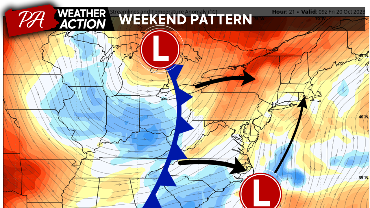
Good Afternoon Everyone! Anyone else getting a sense of deja vu? We can’t seem to shake this pattern of wet weekends. Unfortunately, after a quiet weather week, more rain is on tap for the weekend. A cold front and associated surface trough will move through the region Friday into Saturday. The energy along the leading edge of this trough will initiate the development of a coastal low on Friday that will quickly move up the coast through Saturday, reinforcing rainfall across the region and bringing gusty winds throughout the weekend.
While not quite the washout we got this past weekend, unfortunately, this weekend’s rain may still put a damper on some of your outdoor plans!
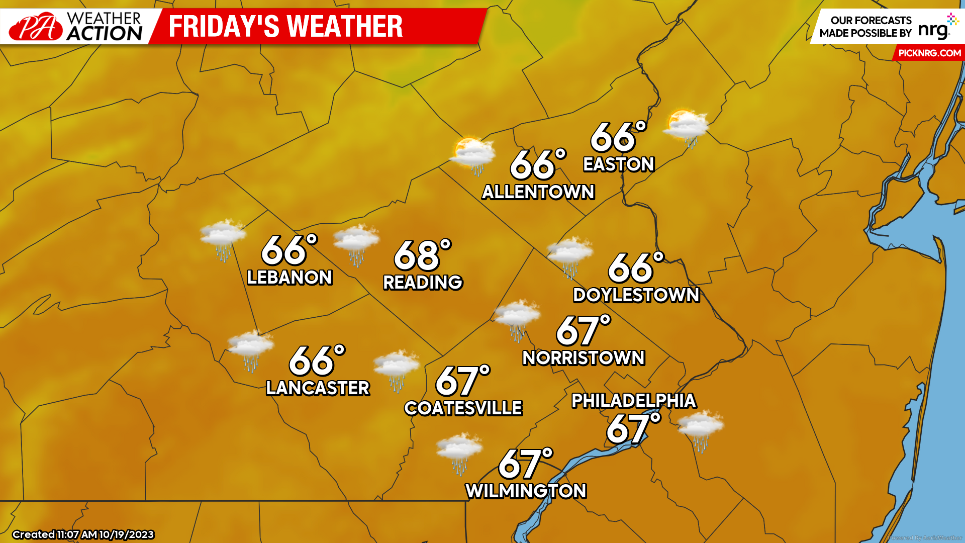
FRIDAY
Expect Friday to begin with mostly cloudy skies in place. Lows Friday morning will start mild in the mid-upper 50s. By mid-morning, waves of showers and thunderstorms will move northward, across the region, out ahead of the approaching front. By the afternoon, expect a brief break in rainfall, with a few peaks of sun possible. High temperatures tomorrow should reach the mid-upper 60s. By evening, another round of gusty showers will move through associated with the main cold front. Expect on-and-off showers to continue throughout Friday night. Winds Friday will be out of the S at 10-15 mph.
Saturday
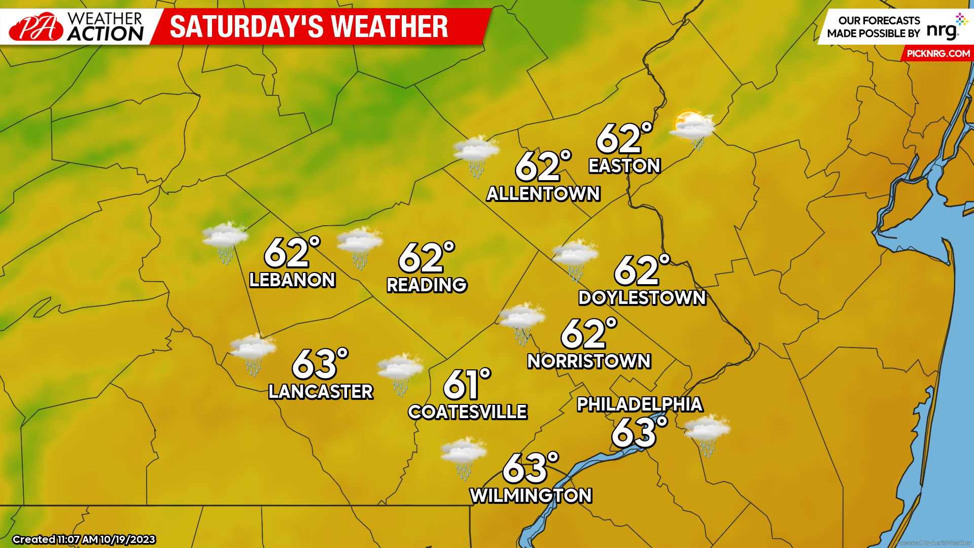
By Saturday morning, expect scattered showers to continue with low temperatures in the low-mid 50s. Our front, now east of the region, will transfer its energy to a rapidly developing coastal low Saturday morning. This low will bring an enhancement of winds and rainfall back to the region by midday, especially across our eastern counties. However, our storm will quickly exit the region to the NE bringing an end to precipitation for most Saturday afternoon. Highs will top out in the low 60s with winds out of the NW at 15-25 mph and gusts to 30mph. By Saturday evening expect cloud cover to remain in place with a few showers still possible, rotating around our storm system.
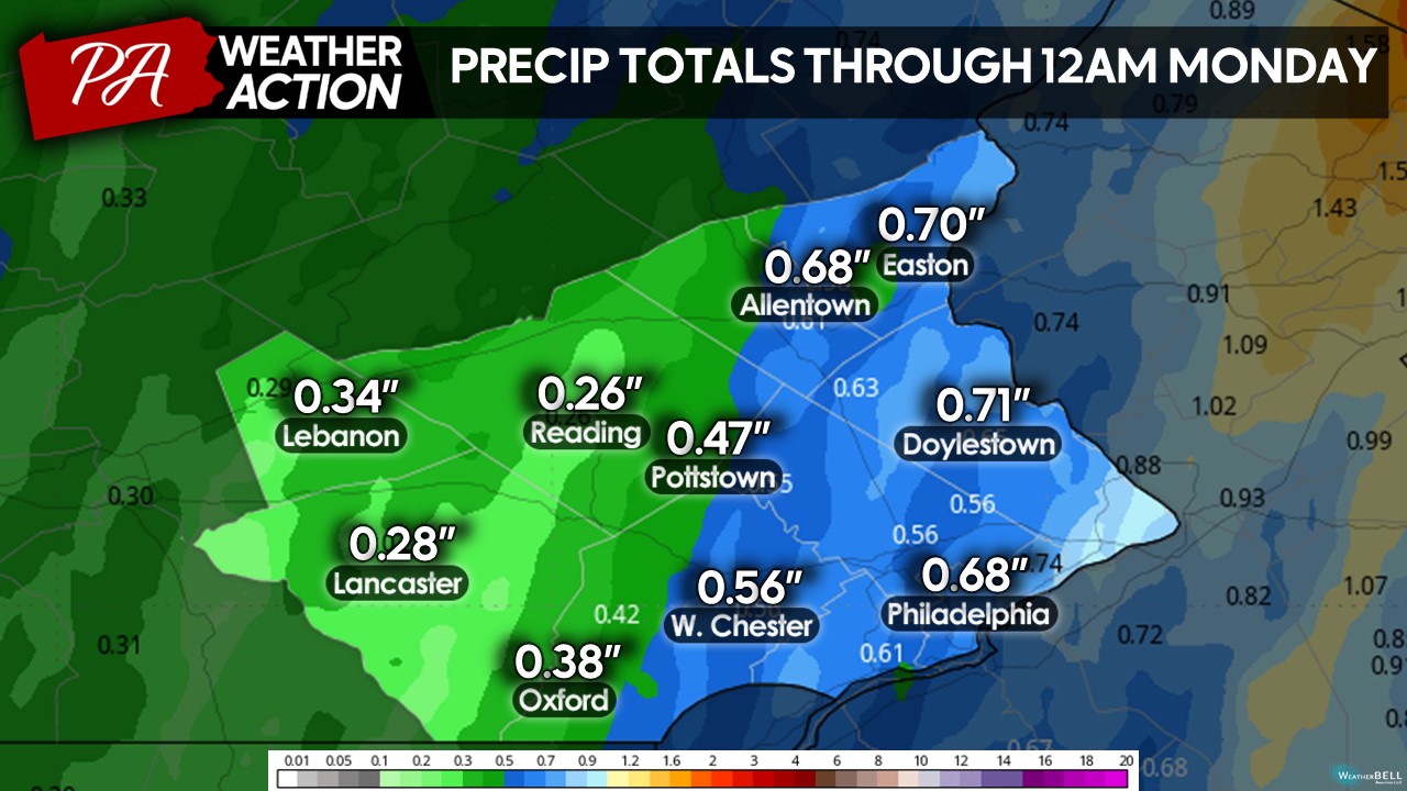
 As mentioned, places through the Delaware Valley and the Philly Metro are set to see the most substantial precipitation. Enhanced rainfall on Saturday, from the redeveloping coastal low, will bring more precipitation to Eastern regions than to Western regions. In general, I expect around 0.25in-1.oin of rain to fall across all areas. A few eastern counties may pick up rain over 1 inch depending on where the heaviest showers develop.
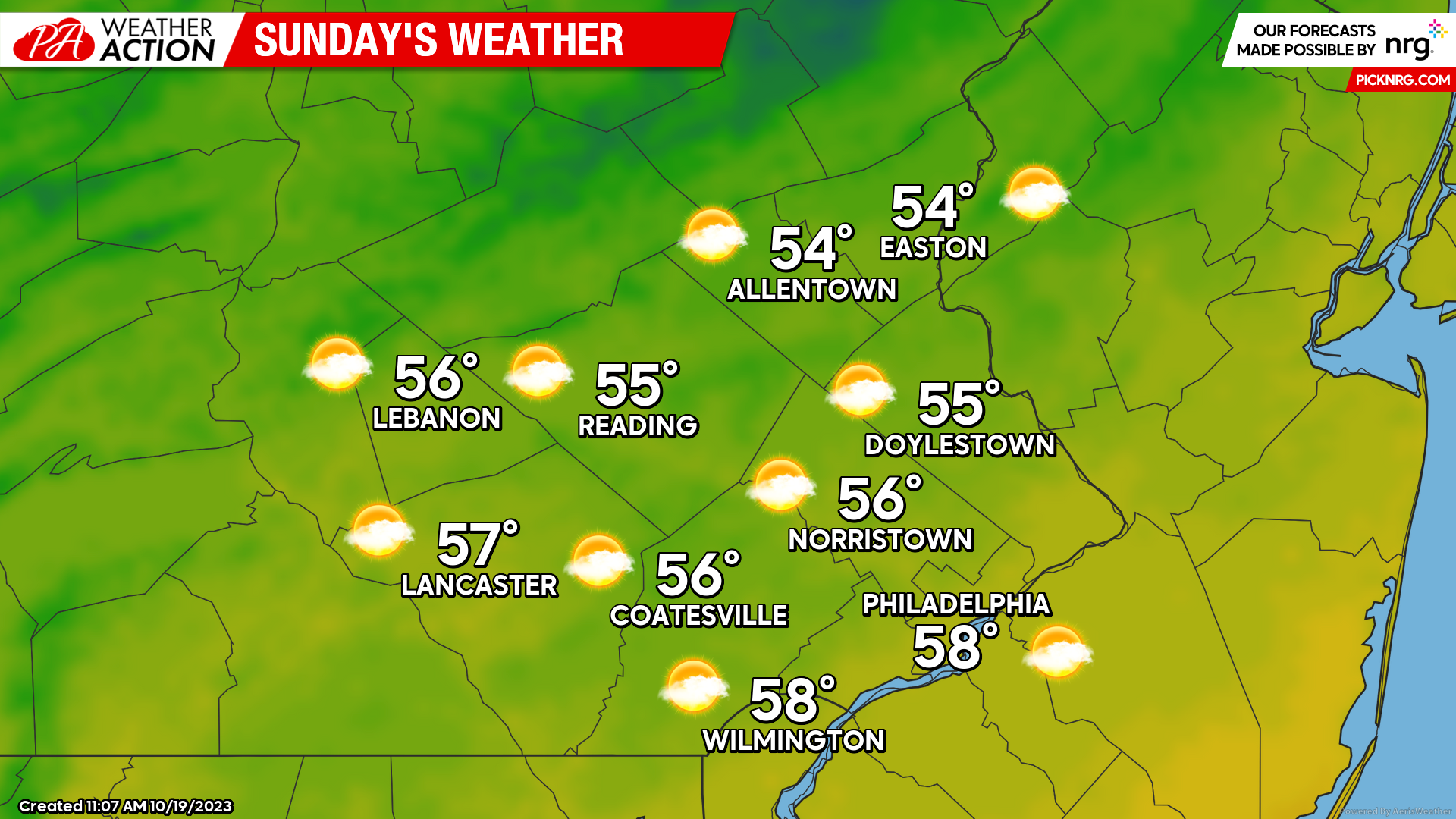
Sunday
Behind our storm system, clearing is expected overnight Saturday into Sunday morning, setting up for a crisp October day. Morning lows will start in the mid-upper 40s under partly cloudy skies. Expect cloud cover to gradually decrease as our storm continues to pull away. However, blustery winds and cold air advection on the back side of our low will keep our temperatures cool. Highs Sunday afternoon should only reach the mid-upper 50s. Winds will remain out of the NW at 10-20mph with gusts to 25mph. Expect mostly clear and cool conditions Sunday night, with many seeing lows in the 30s by Monday morning.
Looking ahead towards next week. Quiet weather looks to dominate once again with seasonably cool conditions to start the week. By midweek a ridge of high pressure is likely to build into the region, bringing more sunshine and a late October warm-up to the region. More updates on this in the next blog! Once again, it’s unfortunate the pattern we are stuck in with rainy weekends. However, I hope all of you will make the most of it! If you have any comments or questions about the forecast, feel free to let me know! Have a great weekend!
-Michael Woytowiez


You must be logged in to post a comment.