
Good Afternoon Everyone! I hope everyone had a happy and fulfilling holiday season! We are into January now, and with that, our mild winter pattern is breaking down as we head towards the heart of the winter season. With that, we are now tracking our first substantial winter storm in a few years for our area, which is set to bring a plowable snowfall to parts of the region. With that being said, this forecast is very tricky as mixing will certainly limit snowfall for some, as is so often the case in SE PA. Minute shifts in track of just a few miles could mean the difference between a few flakes and several inches of snow. Continue reading as I break down the set up for this winter storm and make my best call of how much will accumulate and where!
Friday
A weak clipper system exiting the region Thursday night will usher in cold air associated with an artic high-pressure system. This high pressure will keep local weather chilly but dry for the day on Friday, however this establishes the blocking necessary to bring our threat of winter weather later into the weekend. Expect clear skies Friday morning, with lows dipping into the low-mid 20s. Sunshine will dominate into the afternoon, with highs reaching the mid-upper 30s. Expect winds out of the NW at 5-10mph.

At his point, the primary low for our winter storm will be moving through the south-central US, drawing in gulf moisture as it does so. Simultaneously, a shortwave trough will be diving out of Canada into the northern planes. This shortwave will provide the cold air necessary for our system to develop snow once it phases with the primary low. The blocking high to the east will slow our primary low enough to initiate a phase closer to the coast. This will allow for at least a period of snowfall across the entire region. However, the exact timing of this phase is key to determining who sees snow and how much.

Saturday
By late Friday night through early Saturday, clouds will overspread the region as our low-pressure approaches. Temperatures will start in the mid-upper 20s Saturday morning. Temperatures will rise into the lower 30s by early afternoon Saturday. At this time, precipitation appears to start early Saturday afternoon in the form of snow region-wide. At the onset of precipitation, our primary low will still be phasing with the shortwave, meaning cold air will arrive too late for some.
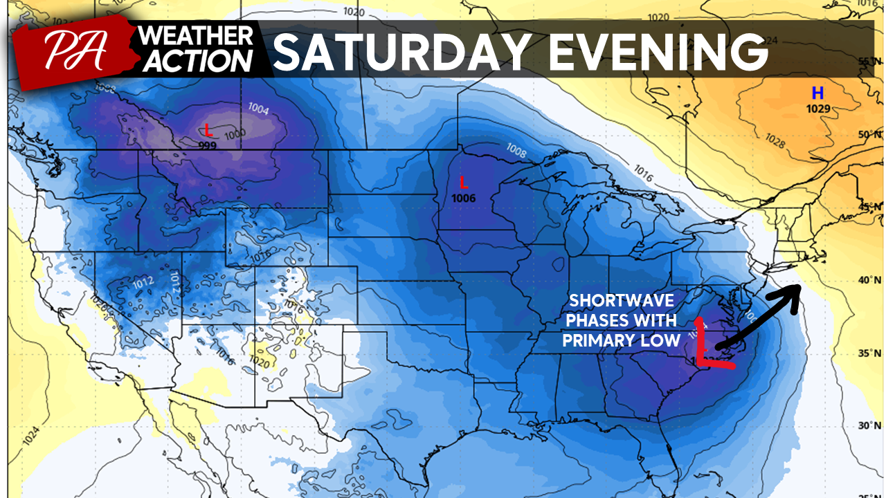
Easterly winds from our primary low will usher in milder air for southeastern portions of our region. This will initiate the transition to mixed precip and eventually rain for these regions Saturday evening. As of now, I expect snow to hold on in areas northwest, leading to more significant accumulations. Temperatures will peak around midnight Saturday night across the region. Expect temperatures to reach the mid-upper 30s across southeast regions, with temperatures holding in the low-30s in areas further to the north. Winds will shift from the E to the NW at 10-20mph overnight Saturday.
Sunday
By early Sunday morning, our low will have finished its phasing with the cold air. This will shift winds to a NW direction and will allow temperatures to drop once again. Many areas will transition back over to snow before precipitation exits. A second period of light-moderate snow is possible region-wide before precipitation wraps up early Sunday afternoon. Temperatures will hold steady on Sunday in the low-mid 30s.

Snow Total Forecast
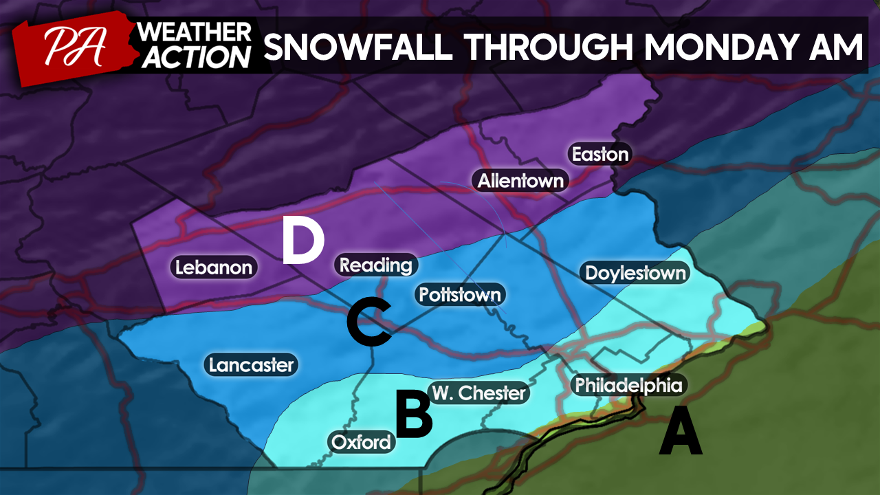
ZONE A: NO ACCUMULATION, 0.75″ – 1″ Rain, Brief wintry mix before changeover to rain Sunday afternoon; may see a few flakes at tail end of storm. Includes areas along I-95 south to the Delaware River, including center city and south Philly
ZONE B: T – 2″ Snow, 0.5″ – 0.75″ Rain, Period of light-moderate snow before changeover to rain Saturday evening, a brief burst of snow to finish Sunday morning. Accumulations will be mostly confined to grassy surfaces. Includes SE Bucks, SE Montgomery, North Philadelphia, S Chester, and SE Lancaster counties.
ZONE C: 2″ – 4″ Snow, 0.1″-0.5″ Rain, Moderate – Heavy snow will changeover to a wintry mix Saturday night. Mixed precip will flip back to Snow Sunday morning. Accumulations mostly on grassy surfaces, some slick roadways possible especially in higher elevations. Includes NW Bucks, NW Montgomery, SE Berks, Most of Lancaster County.
ZONE D: 4″ – 8″+ Snow, Moderate-Heavy snow Saturday afternoon – Sunday morning, brief wintry mix possible around midnight Saturday night in lower elevations. Accumulation on grass and roadways. A few areas may exceed 8 inches in the heaviest bands and higher elevations. Includes I-78 corridor, Northampton, Lehigh, NW Berks, and Lebanon counties.
What could change
As mentioned, snow accumulations will be largely dependent on the phasing of our system. Some models are suggesting a later phase or a more amplified storm track which would increase warm air transport from the ocean into SE PA. This would reduce totals region-wide. On the flip side, an earlier phase could lead to a stronger storm, which would increase moisture transport into the cold air. This would increase totals, especially across northern portions of our region. I believe the higher elevations of Lehigh and Northampton counties have the greatest opportunity to overperform. I will have another blog out tomorrow evening to detail any changes and the precise timing of our storm.
Looking Ahead
Although this storm will not be the blockbuster storm that some were hyping about, it is the most significant winter storm threat we’ve seen in some time. Make sure you plan travel accordingly and shake the dust off your shovels and snow plows. Looking ahead, the evolution of this storm will play an important role in the development of a midweek storm. As of now, this storm looks to come mostly in the form of rain; however, heavy rain and wind on top of a melting snowpack could create flooding and wind damage problems for our region.
We are looking at quite a busy period of weather over the coming days and weeks, I will do my best to update as our weather evolves! If you have any questions or comments regarding the forecast, feel free to let me know! I will provide an updated blog tomorrow evening.
-Michael Woytowiez
You must be logged in to post a comment.