
A mesoscale (small area) convective (thunderstorm) system developing in Michigan early this evening has serious potential to form a derecho (>240 mile path of damaging winds) that will move into Western Pennsylvania by early Tuesday morning. Damaging winds are possible in Southwest PA before sunrise Tuesday, so if you have anything that may blow away, secure it to the ground or take it inside before you go to bed tonight. We will more than likely see all areas south of Meadville, Altoona, and Chambersburg see at least 40mph gusts, but the focus area is Southwest PA where extensive wind damage is possible.
Timing for this threat in Western Pennsylvania for areas west of Johnstown and Somerset will be 3:00 – 7:00 AM Tuesday. In South Central PA, timing will be between 6:00 AM – 10:00 AM. The highest winds will likely occur in the first hour or two within the timing for those regions. Below is the latest HRRR future radar for these storms.
DAMAGING WIND RISK FOR TUESDAY MORNING
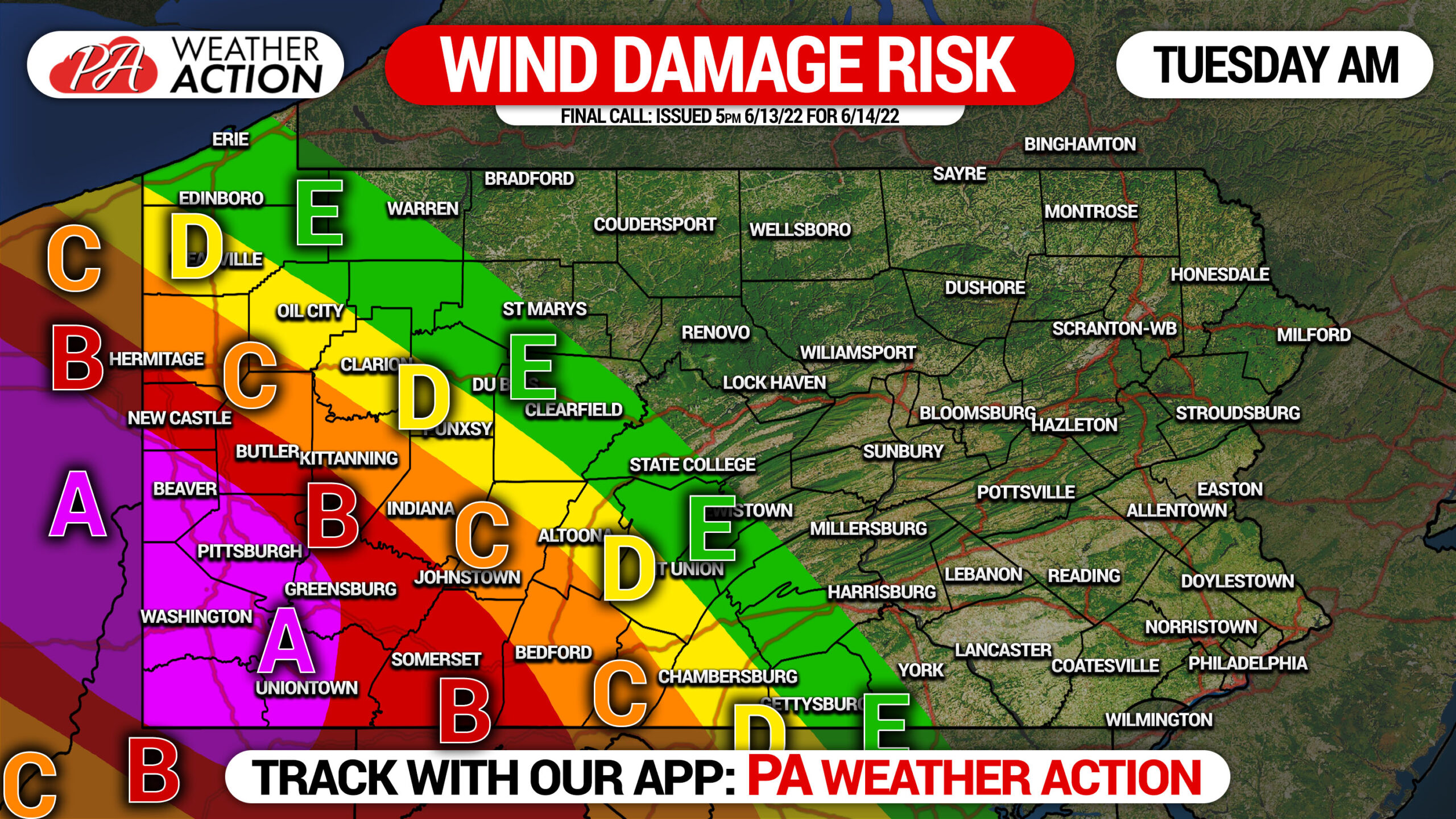
In all areas, secure all outdoor items such as umbrellas, furniture, etc. Watch for debris on roads during the Tuesday AM commute.
Area A: Widespread wind gusts exceeding 50mph, scattered gusts of 65-75mph possible. Extensive wind damage is possible, resulting in downed trees and powerlines.
Area B: Wingspread wind gusts exceeding 45mph, scattered gusts of 60-70mph possible. Considerable wind damage is possible, resulting in downed trees and powerlines.
Area C: Widespread wind gusts exceeding 40mph, scattered gusts of 55-65mph possible. Localized wind damage is possible, resulting in downed trees and powerlines.
Area D: Widespread wind gusts exceeding 35mph, isolated gusts of 50-60mph possible. Localized wind damage is possible, resulting in downed trees and powerlines.
Area E: Widespread wind gusts exceeding 30mph, isolated gusts of 45-55mph possible. Localized wind damage is possible, resulting in downed weaker trees.
Please share this article with family and friends who may be unaware of this below.
[social_warfare]
Track the storms tonight and the latest models we showed you above with our free app! Tap the banner to open it on your phone’s app store.


You must be logged in to post a comment.