
Good Evening Everyone! Thursday morning brought widespread low temperatures in the 20s and low 30s across the area, bringing the official end to the growing season for Southeast PA. However, after a chilly start to the week, a moderation in temperatures is on the way for the weekend. A high-pressure system will shift to the East of our area, allowing for southwesterly winds to moderate temperatures into the weekend. Additionally, for the first time in 8 weeks, no rain is in the forecast for this weekend. Continue reading for more details!
October Recap
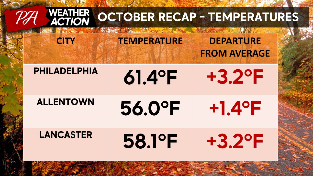
First, taking a look back at how October’s weather shaped up compared to average. For the entirety of the region, October shaped up warmer and shockingly drier than average. Generally, temperatures ranged anywhere from 1 – 4 degrees above average throughout the period. Temperature data for a few major cities are shown below.
Additionally, all of Southeast PA carried a rain deficit throughout the month, with southeastern portions of the region, around the Philly metro, developing the largest deficits. This may be hard to believe, given that every weekend of the month brought the threat of some rain. However, the vast majority of October’s rain fell on the weekend, with the weeks in between being mostly dry. We are just the unlucky ones, I guess! Rainfall data for a few major cities is shown below.

Friday
Clear skies tonight will allow temperatures to dip quite significantly once again. Morning lows across the region should range from the upper 20s – mid-30s. High pressure will keep clouds at bay through Friday. Winds will be out of the S at 5-10 mph. The combination of southerly winds and sunny skies will kick off a warming trend throughout the weekend. High temperatures on Friday will be much warmer than in recent days with highs topping out in the mid-upper 50s.

Saturday
A few clouds Friday night will moderate low temperatures slightly Saturday morning. Lows Saturday should range from the mid-30s – low 40s. Scattered cloud cover will remain in place throughout Saturday, however, no precipitation is expected! Temperatures on Saturday will to out in the low 60s. Winds will be out of the SW at 5-10mph.

Sunday
Low temperatures will continue to moderate into Sunday morning, with lows in the low-mid 40s across the region. High pressure will continue to dominate our weather with just a few scattered clouds in place. High temperatures on Sunday will range from the low-mid 60s. Winds will be out of the W at 5-10mph.

Looking ahead to next week, dry weather looks to continue through Monday. However, a cold front will slide through the region midweek, bringing the next chance for widespread rainfall and another drop in temperatures. All in all a very pleasant fall weekend is on the way for the region. I hope you all are able to get out and enjoy it. If you have any questions or comments about the forecast, feel free to let me know!
-Michael Woytowiez


You must be logged in to post a comment.