
Good afternoon! As we head into the new week, some of the coldest air of the season will filter into the region, which will allow for widespread snow showers and snow squalls with very cold temperatures. These will be some of the coldest temperatures yet this season! However, the cold blast will be rather short-lived as we will see temperatures rebound by the end of the week. Let’s jump into the forecast!
TUESDAY:
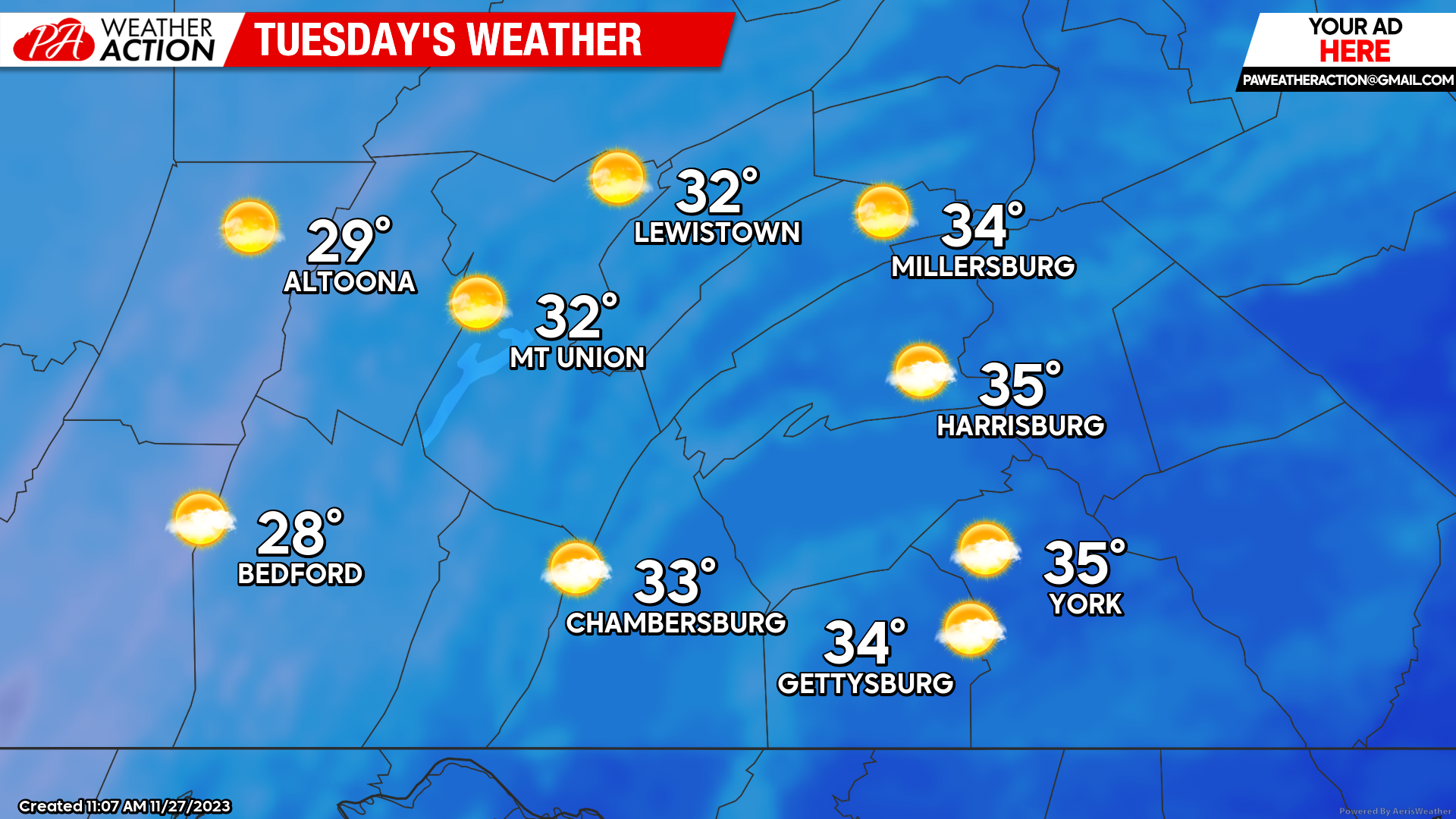
Tuesday will bring the coldest day of the season yet as an arctic front passes through the region. Expect high temperatures to range from the upper-20s to mid-30s across the region with a mix of sun and clouds. Throughout the afternoon there may be scattered snow showers and snow squalls, which may briefly reduce visibility at times and may briefly cover surfaces and roadways. If you are planning to travel, be aware of these squalls and slow down when necessary! Combined with the cold conditions, we will see a westerly wind of 15-25 MPH with wind gusts 35-45 MPH across the region, making the wind chill values in the teens for much of the day across the area. If you haven’t brought out your winter coats yet- it may be time to do so tomorrow!
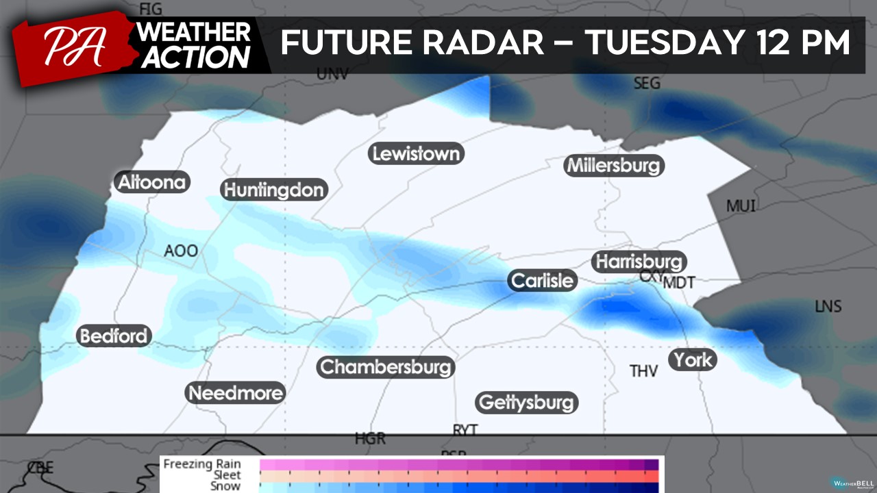
Taking a look at the future radar, expect snow showers and snow squalls throughout the day tomorrow, with the best threat from 8 AM through 2 PM. As these showers and squalls pass through, expect temporary reductions in visibility and road conditions, which may make travel tricky at times. If you are on the roadways during a squall, please slow down your speeds! Snow squalls are one of the most dangerous winter weather conditions, especially for highway travel. Total snowfall accumulations should accumulate to less than an inch in lower elevations and 1 to 3 inches in the higher elevations.
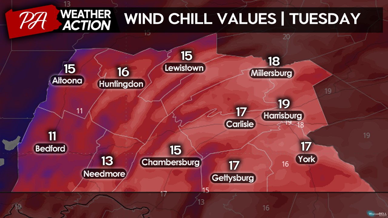
One of the bigger weather factors tomorrow will be the wind chill! With wind gusts up to 35-45 MPH across the region, it will be feeling quite bitter outside tomorrow afternoon. Expect the entire region to experience wind chills in the teens throughout much of the day tomorrow, with some areas in the higher elevations experiencing wind chills in the single digits and potentially around zero degrees! If you are planning to be out and about tomorrow, remember to bundle up to prevent any cold illness risks, especially if you are planning to be out for prolonged periods of time.
WEDNESDAY:
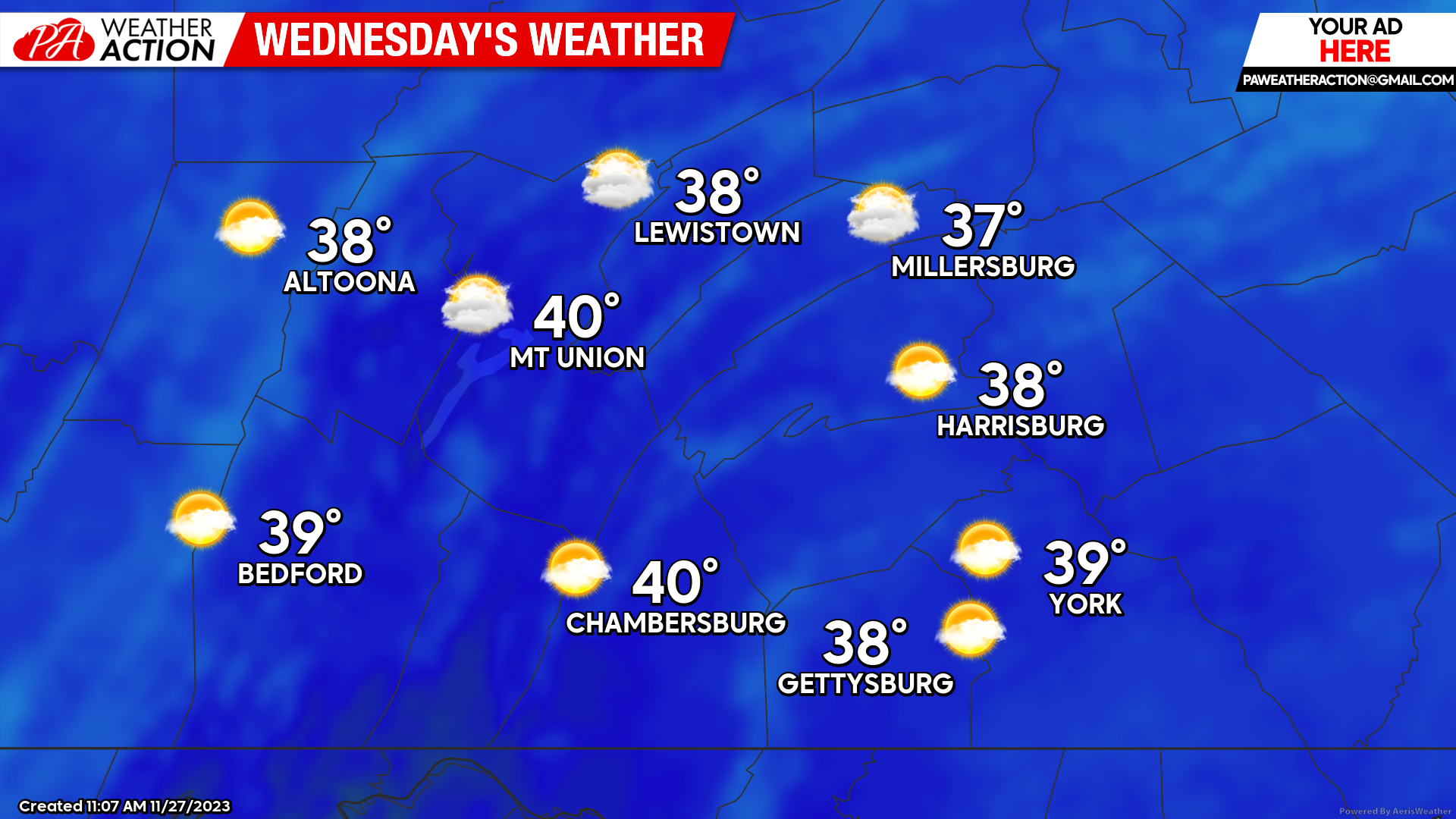
We will see a slight warmup as we head into the middle of the week- although temperatures will still remain quite chilly across the area. Expect high temperatures to climb into the upper-30s to lower-40s with a mix of sun and clouds. We will see a southerly wind develop during the afternoon hours of 5-10 MPH, making the air temperatures feel slightly cooler.
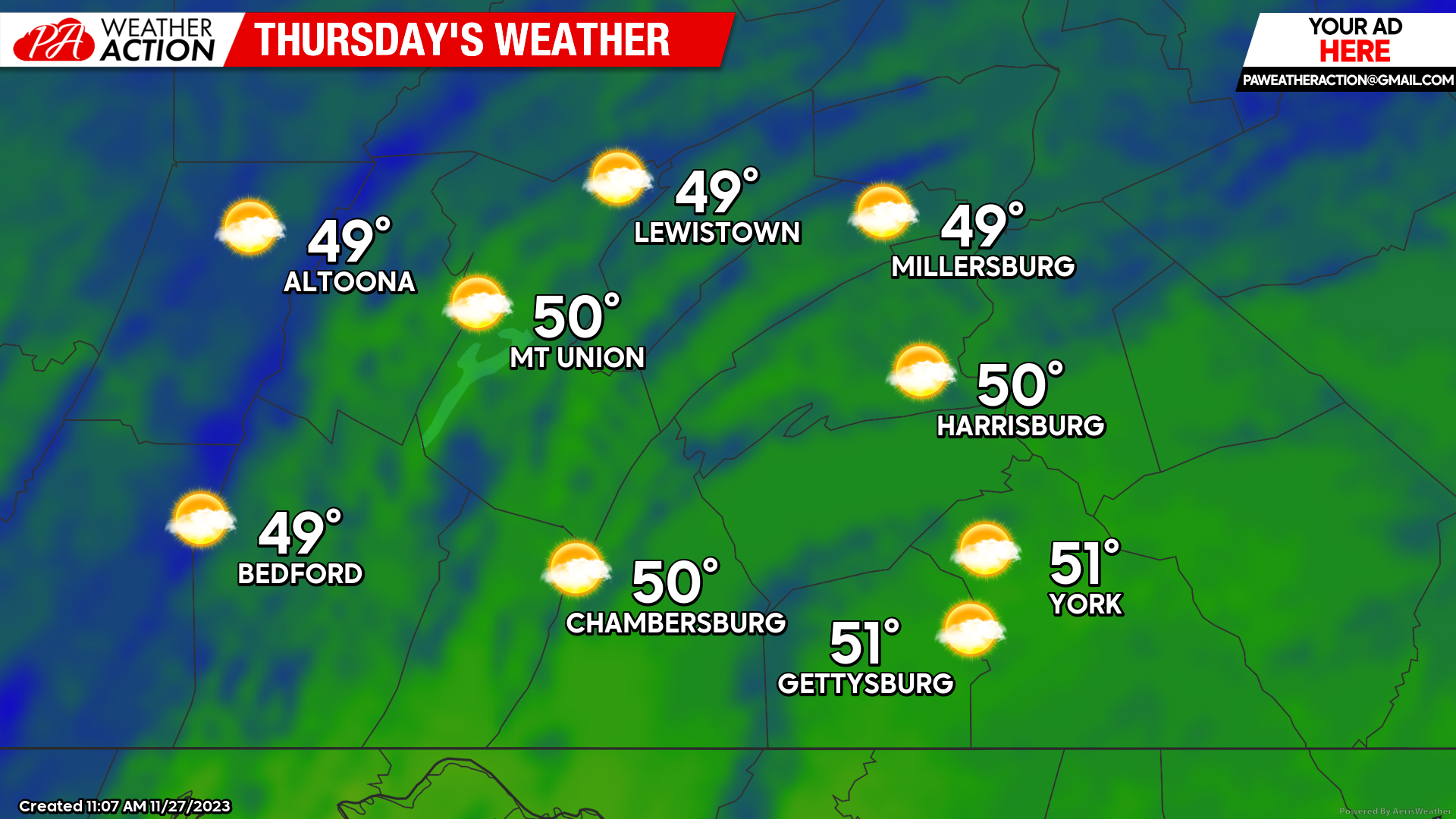
 THURSDAY:
Thursday will bring our warmest day of the week as high temperatures climb into the upper-40s and low-50s. These temperatures will hover a bit above average and it will feel a lot warmer compared to our temperatures on Tuesday. Expect a mix of sun and clouds throughout the afternoon as well with a southerly wind of 5-10 MPH. Not too bad of an afternoon, it could be a whole lot worse!
 As we close up the week, our next threat for precipitation will be Friday afternoon and evening. Due to warmer air in the region, this event will likely be an all-rain event but may hamper outdoor plans during the afternoon and evening hours. Beyond that, there is no real indication of any incoming widespread winter weather events so if you are a snow lover you may have to be patient for a bit longer. If you have any questions regarding the forecast, feel free to reach out!
– Denys
You must be logged in to post a comment.