


Meteorological winter begins in seven weeks. Yet in many areas, fall foliage color remains low. Will this warm and dry pattern continue into winter? We will do our best to answer that question in this year’s Preliminary Winter Outlook. Feel free to scroll to the bottom to view our snowfall and temperature outlooks. For those that appreciate the technical discussion, continue reading.
There is no hiding the fact that the last two winters have been warmer than average and in general less snowy. Fortunately for the snow lovers out there, the state did experience one major snowstorm during each season. Take out those two storms and many of us would have essentially experienced back to back snow-less winters.
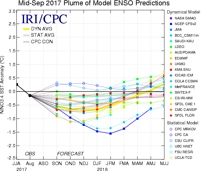
For the upcoming winter season, we are anticipating an East-based Weak La Nina to drive our overall weather pattern. Below is model projections showing ENSO predictions between 0.0 and -1.0°C during the prime winter months of December, January, and February (DJF).
Sea surface temperatures in the Equatorial Pacific will be rising as winter progresses. However there is much more to look at. A warm PDO is beginning to develop as water temperatures on the west coast are above average. In addition, the area of below average SSTs in the Northcentral Pacific has only been cooling even more lately. Depicted on the map below is global sea surface temperature anomalies.
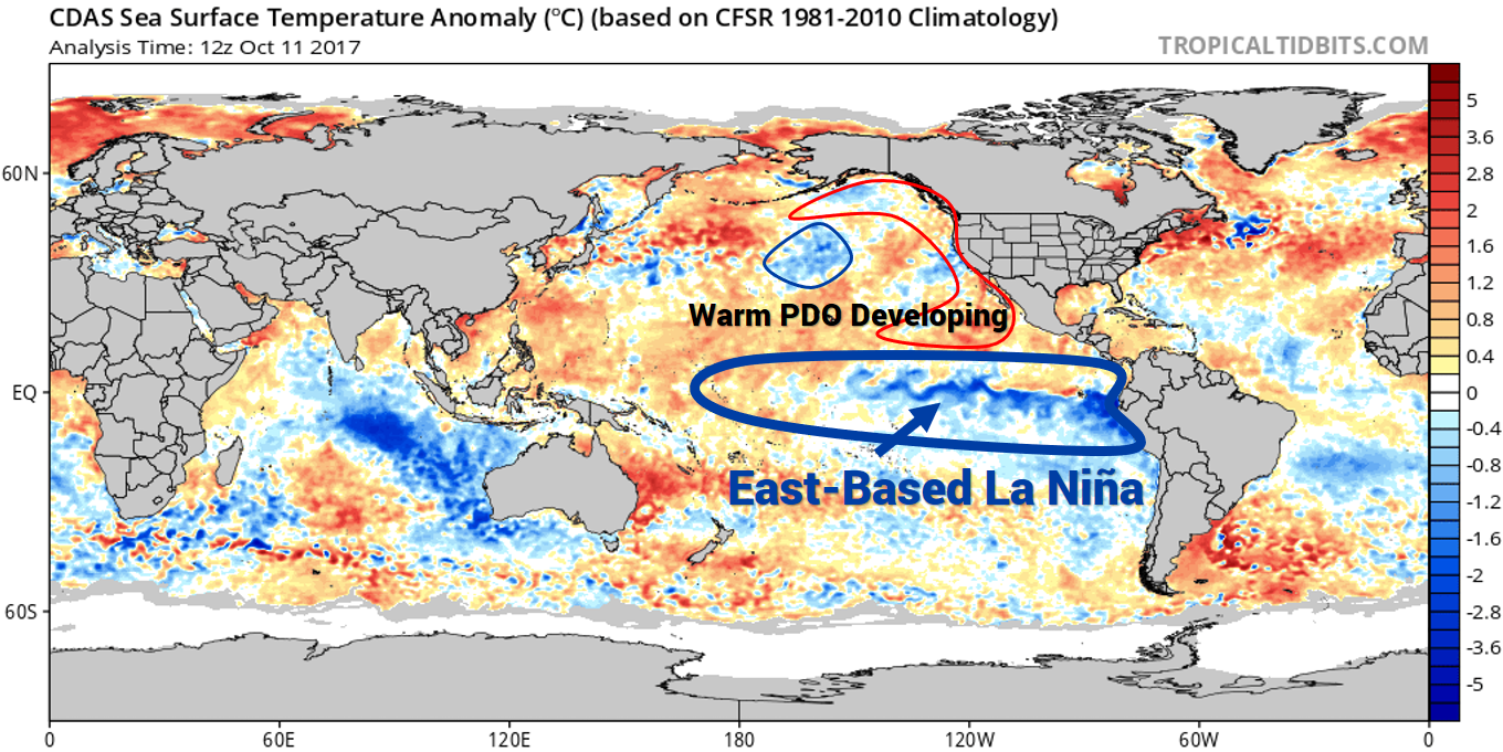
Water temperatures off the western coast of Mexico have been warming which is often a sign of a warming PDO. This would support ridging on the west coast. With that said, a favorable PDO does not always directly impact the pattern.
Another prominent factor going into this winter is the Quasi-Biennial Oscillation (QBO). Right now, the QBO is at -15.28. This is a wild card. If the QBO rises closer to -10 with easterly winds, the probability of more sudden stratospheric warming events will increase.
This would cause the “polar vortex” to make several appearances in the Central and Eastern US throughout winter. Again this is currently a wild card. We will know more regarding the QBO by the time of our Official Winter Forecast in November.
Our analogs are based on several factors. We selected seven winters that had a similar East-Based Weak La Nina, QBO, and PDO. While the analogs go in order by year, our top analog is currently the winter of 1962-1963. Here is what our analogs suggest for this winter.
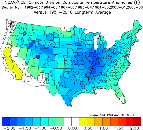
Overall, this matches a Weak East-Based La Nina well. The west coast was a bit warmer than average during these years, while the core of the cold is centered over the Central United States. Some of that cold made its way into the interior locations of the Eastern United States.
PRELIMINARY 2017-2018 TEMPERATURE OUTLOOK
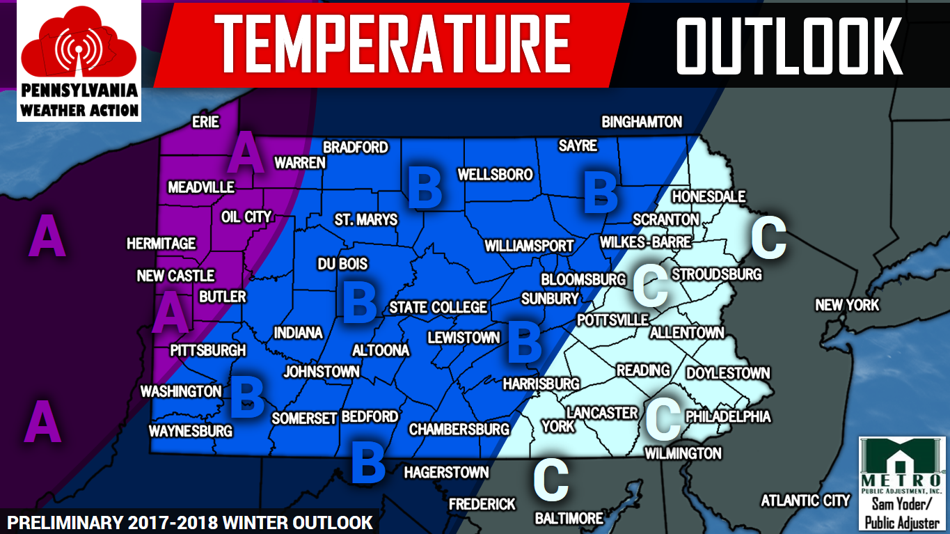
Area A – Below normal temperatures expected. Sustained periods of cold temperatures is to be anticipated in this region. Temperatures will average 1.5 to 2.5 degrees BELOW normal.
Area B – Slightly below normal temperatures expected. Consistent cold shots are anticipated along with a few warmer periods. Temperatures will average 0.5 to 1.5 degrees BELOW normal.
Area C – Average temperatures expected. Temperatures swings are anticipated across this region which will lead to many locations averaging normal temperatures. Temperature will average +/- 0.5 degree.
2017-2018 PRELIMINARY SNOWFALL OUTLOOK
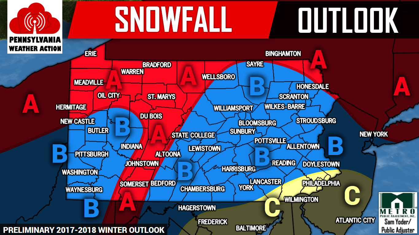
Area A – Above average snowfall is anticipated this winter season. This winter will be active with frequent winter storms. Most of the time these areas are expected to be on the snowier side of the systems.
Area B – Average snowfall is expected. With an active storm season, there will be plenty of storms that result in all snow or a slushy mix, and occasionally ice. Some storms will be mainly rain events.
Area C – Below average snowfall is expected. We anticipate these areas to be on the warmer of side of many winter storms this season cutting down on season snow totals.
Make sure you have us liked and followed on Facebook for all the latest forecasts and more as we approach the winter months>>>Pennsylvania Weather Action’s Facebook Page
Also, download our app for the latest winter storm forecasts during the season. Click here>>> Pennsylvania Weather Action’s App
Share the wintry news with your family and friends by using the icons below!
You must be logged in to post a comment.