
We have had one of the quietest severe weather seasons in recorded history in Pennsylvania this year. Right now is actually the peak of normal severe season in PA, but you’d never guess that if you just moved to the state recently. Finally though, we have a decent potential on our hands for Monday.
SUMMARY
Unstable dynamics will fire off thunderstorms with the capability of producing damaging winds and large hail ahead of a strong upper level trough Monday.
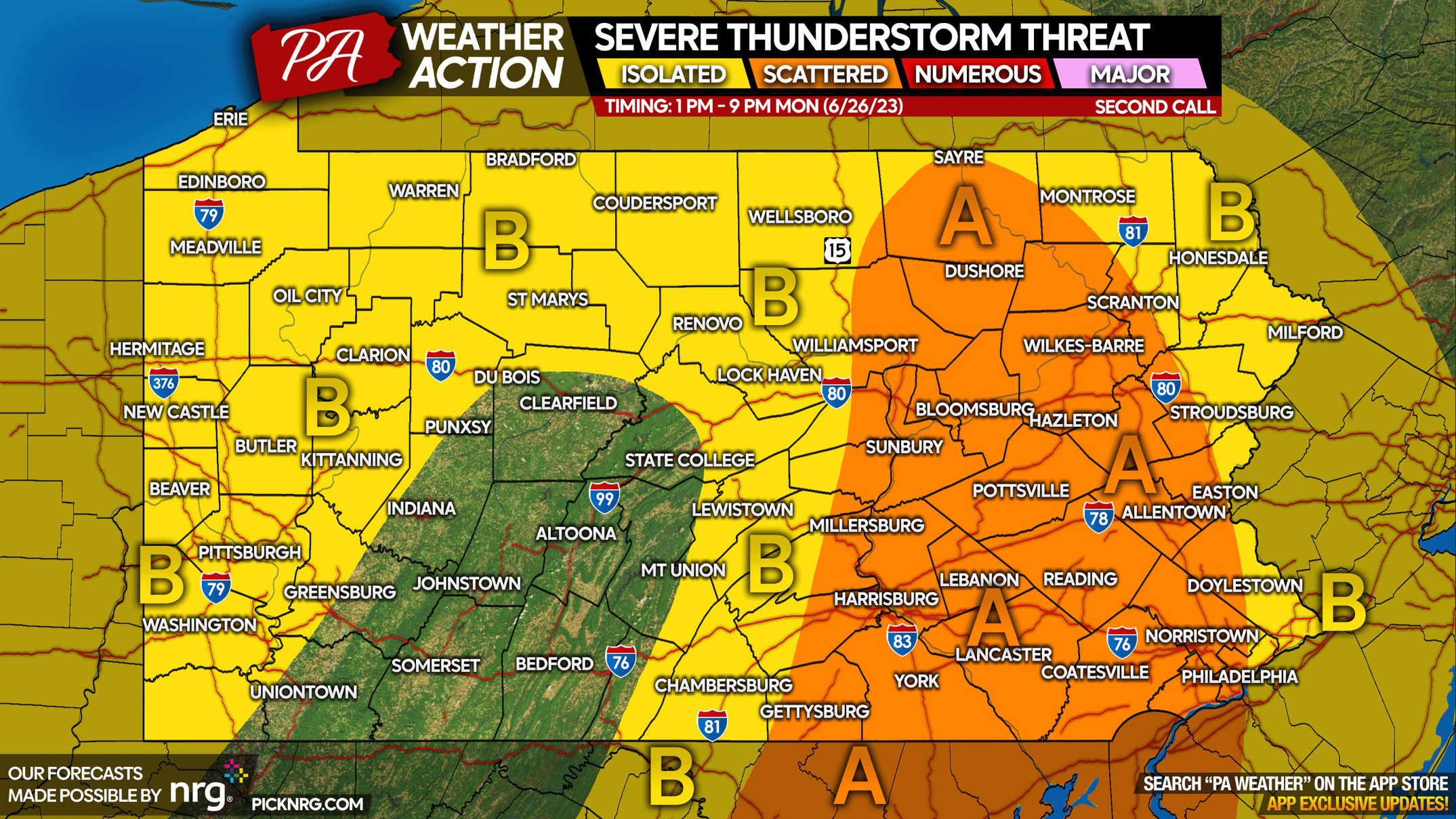
This will be the first major application of Pennsylvania Weather Action’s severe thunderstorm threat scale, which illustrates chances for severe thunderstorms in your area, as well as risk parameters on a scale of 0 to 10. Above our forecast, we will include a link to the NWS Storm Prediction Center’s forecast for those who’d like to compare. This forecast is technically our second call, with our first call available yesterday in our app!
STORM TIMING
Ordinary thunderstorms will fire over the eastern spine of the Appalachians early Monday afternoon, as typical on days like this. These storms will rapidly strengthen in the Susquehanna Valley, forming a broken line of severe thunderstorms by around 3 – 4 PM Monday. From there, the broken line of severe thunderstorms will push into Eastern PA by around 5 – 7 PM Monday. This is when storms are expected to be most intense. As we near sunset and storms near the Delaware River, slow weakening of the line is modeled as daytime dynamics diminish. View Hi-Res NAM Future Radar below.
SEVERE THUNDERSTORM THREAT FORECAST FOR MONDAY (6/26/23)
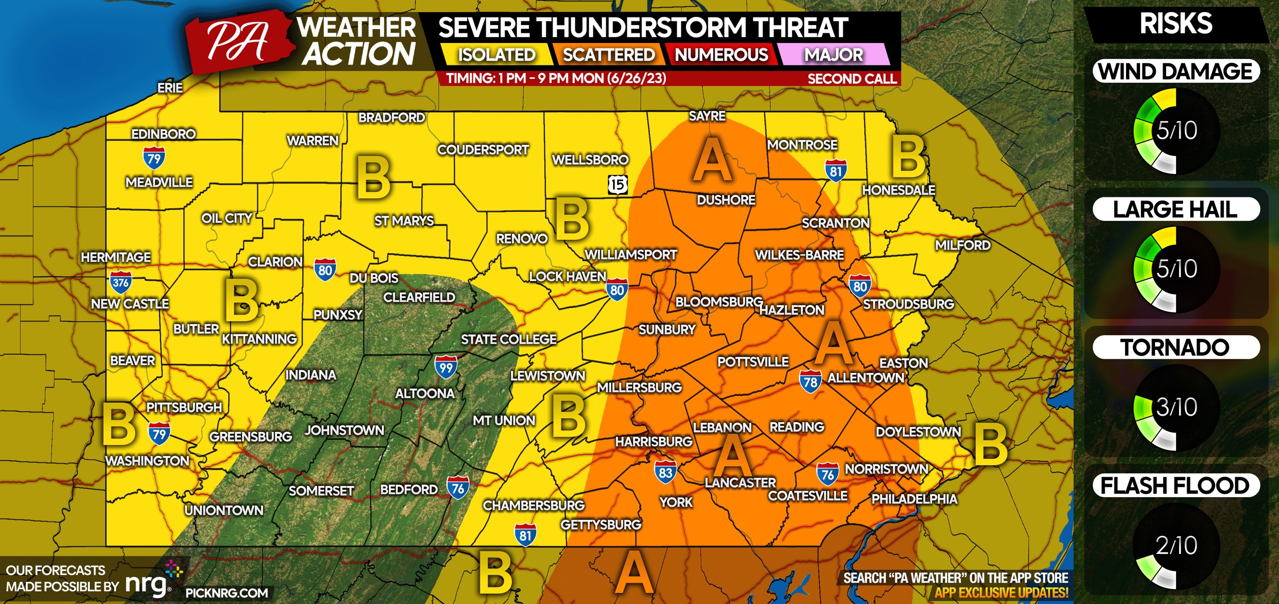
Area A: Scattered severe thunderstorms are expected late Monday afternoon into the mid evening. A broken line of storms will deliver impacts to most locations in this region, however most impacts will be under severe criteria. Main risks include damaging winds of 50 – 60 MPH and large hail. A very isolated tornado and flash flood risk exists.
Area B: Isolated severe thunderstorms are expected mid Monday afternoon into the early evening. In Central & Eastern PA, ordinary thunderstorms are expected, but this area is outside the region of most unstable dynamics. In Western PA, scattered ordinary thunderstorms will roll in from Ohio around dinnertime Monday. In all Area B regions, isolated severe activity is possible but most storms will pack wind gusts of 25 – 45 MPH and small hail.
We will have an update to this forecast Monday morning, so I’d advise joining our Facebook group where we can notify you instantly only when an important forecast is posted. Notifications are only used when needed!

Many people haven’t had to think about severe storms in a long time, so don’t forget to share this forecast with friends & family below!
[social_warfare]
A message from our sponsor, NRG:
With the damaging winds possible Monday, NRG wants to help make sure you are prepared. As a longtime supporter of PA Weather Action and its mission to keep you informed of weather events ahead of time, we offer these tips to help reduce your risks of damage and injury.
- Bring pets and children inside.
- Secure any objects on your property that are loose and lightweight. If possible, put your vehicle in your garage.
- If you are on the road, reduce your driving speed.
- Avoid and report to police or the local utility company downed power lines.
Download the PA Weather Action App for the most accurate local forecasts, great interactive radar, and all our forecasts & updates! Tap the banner below.


You must be logged in to post a comment.