
After an uneventful first half of severe thunderstorm season across Pennsylvania, Monday looks to bring the threat of numerous severe thunderstorms to a good portion of the state.
An unusually strong upper level low will swing through late Monday, but moist, unstable air ahead of it will create an optimal environment for the development of supercell thunderstorms.
This will be a simplified format, as our graphics now hold a bit more information. If you would still like to see future radar in our posts, let us know on Facebook!
TIMING FOR MONDAY’S THUNDERSTORMS
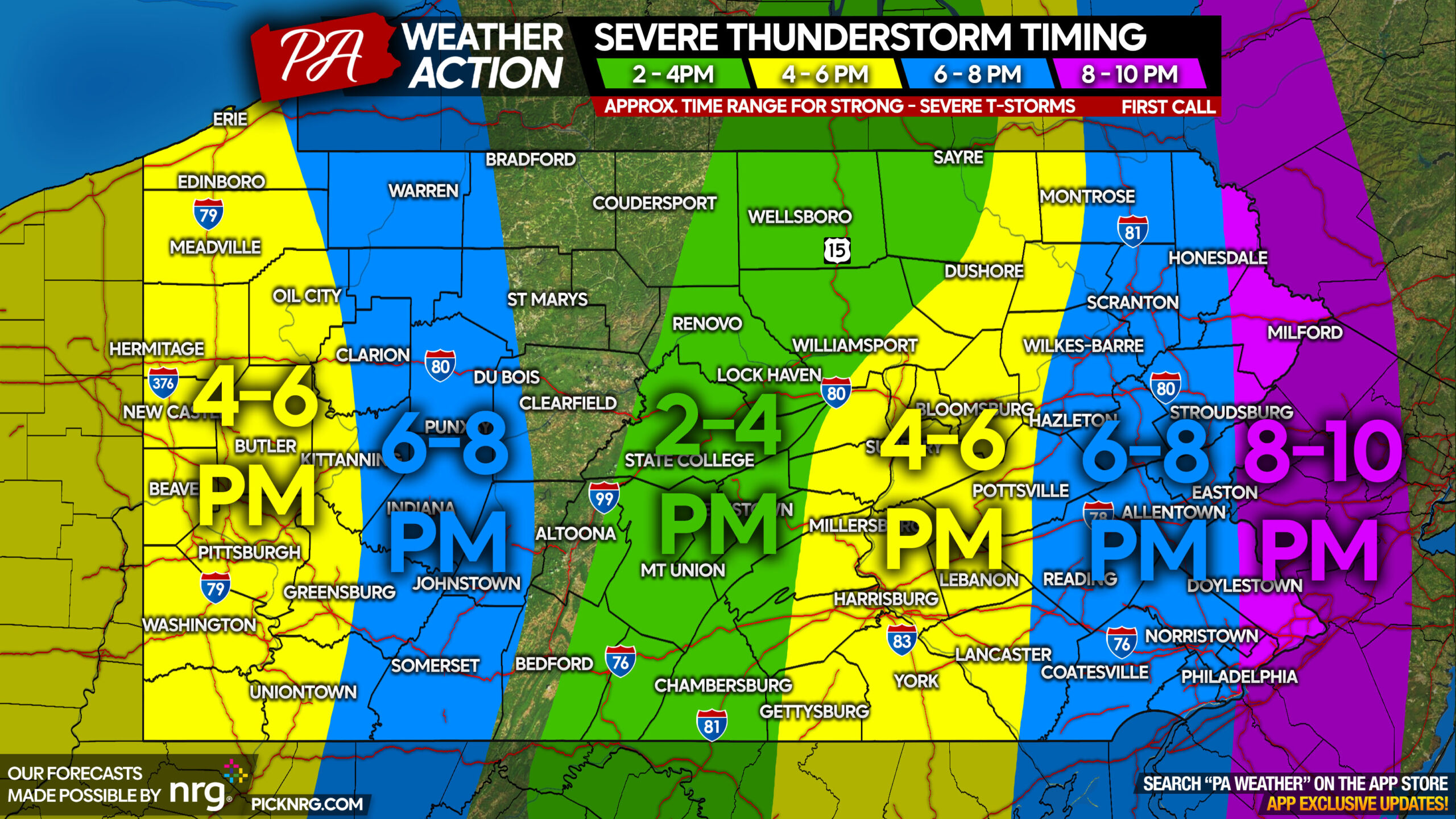
Central & Eastern PA: Severe thunderstorms will develop over the higher terrain in Central PA early Monday afternoon, before rapidly strengthening and organizing into a broken line of strong to severe thunderstorms as they push into the Susquehanna Valley by late Monday afternoon. We expect storms to be pushing through Eastern PA for the Monday evening rush, so that will create some headaches. By sunset Monday, storms will near the Delaware River and are expected to be weakening.
Western PA: A few strong thunderstorms are expected to develop in Eastern Ohio mid Monday afternoon before pushing into Western PA by late Monday afternoon. They will then slowly dissipate as they push into the higher elevations around sunset.
SEVERE THUNDERSTORM THREAT FORECAST FOR MONDAY (6/26)
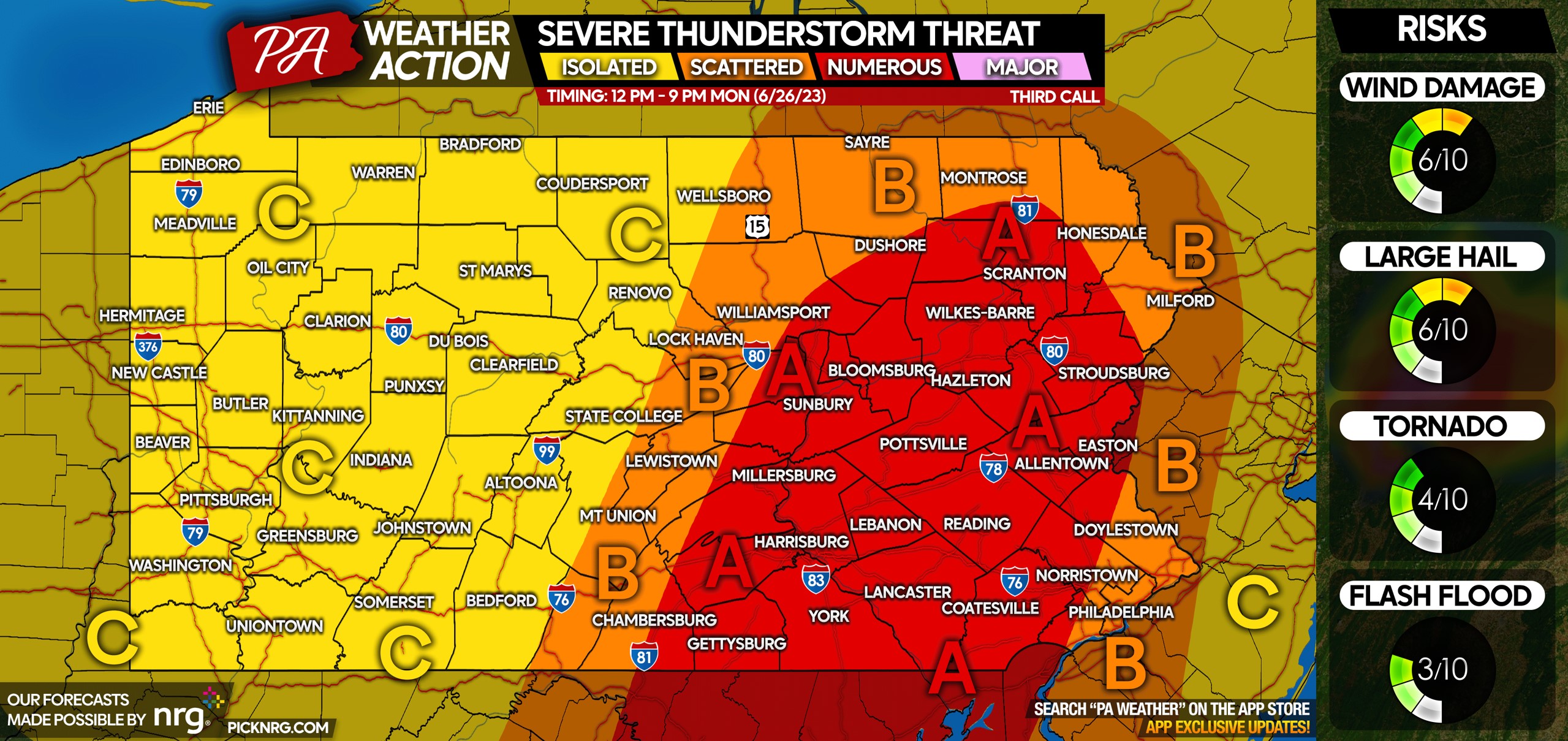
Area A: Numerous severe thunderstorms are possible late Monday afternoon into the mid evening. Not all storms will be severe, but those that are may bring damaging winds of 55 – 70 MPH, large hail, an isolated tornado, and urban flash flooding.
Area B: Scattered severe thunderstorms possible early to mid Monday afternoon on the western side of this area, and late Monday evening on the eastern side of this area. On the western side, thunderstorms will popping up just after lunchtime, and will be hit or miss. On the eastern side, the concern is more so what’s left of the line of storms Monday evening. Many storms in this area will not be severe, but those that are may bring damaging winds, hail, and possibly an isolated tornado (more favorable on the western side).
Area C: Isolated severe thunderstorms possible late Monday afternoon into the mid evening. Most storms will be ordinary thunderstorms to a few strong ones. The severe threat is much lower here. The main threats are gusty winds and small hail.
Be sure to pass along this important forecast to friends and family below!
[social_warfare]
Our app has even more specific information for your area regarding timing, risks, and great radar! Tap the banner below to get it free!

A message from our sponsor, NRG:
With the damaging winds possible Monday, NRG wants to help make sure you are prepared. As a longtime supporter of PA Weather Action and its mission to keep you informed of weather events ahead of time, we offer these tips to help reduce your risks of damage and injury.
Bring pets and children inside.
Secure any objects on your property that are loose and lightweight. If possible, put your vehicle in your garage.
If you are on the road, reduce your driving speed.
Avoid and report to police or the local utility company downed power lines.
You must be logged in to post a comment.