
We continue to watch the potential for a significant winter storm beginning Sunday afternoon, and possibly lasting all the way until Tuesday morning in parts of Pennsylvania. As model guidance starts to converge on a probable solution, we are entering the “this storm is actually happening” phase. We know that especially even more so recently, there has been lots of social media buzz about storms that didn’t end up happening. The good news is we are exiting that model buzz phase that typically happens 5-6 days out.
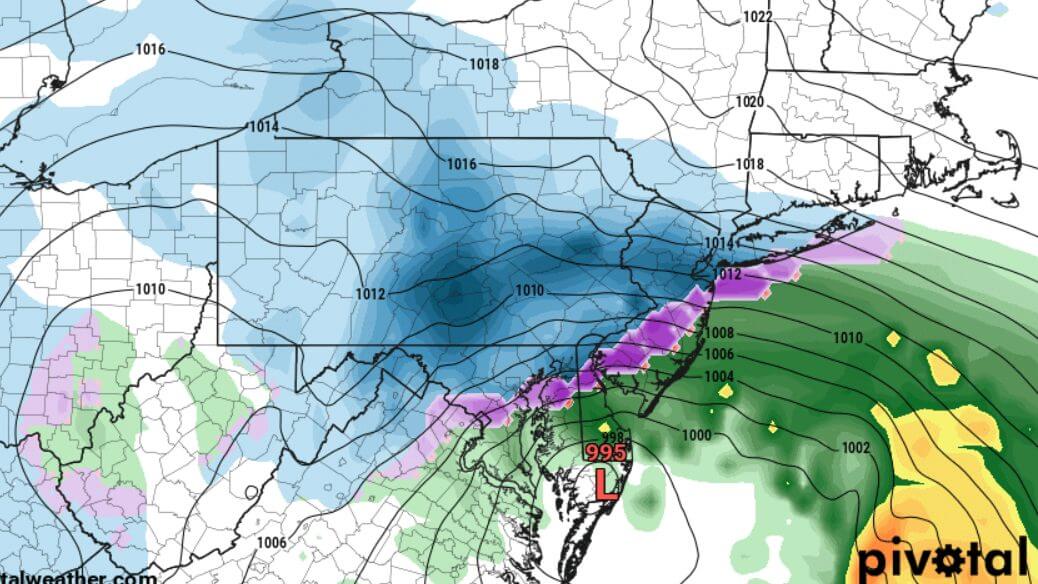
A storm system currently on the West Coast will make its way across the country in the coming days. The low pressure system will move into the Ohio Valley on Sunday, bringing a wave of light to moderate snow to much of Pennsylvania Sunday afternoon and evening. That system will then transfer energy to the coast, causing a coastal storm to form near Cape Hatteras early Monday morning. This is where details begin to get fuzzy.
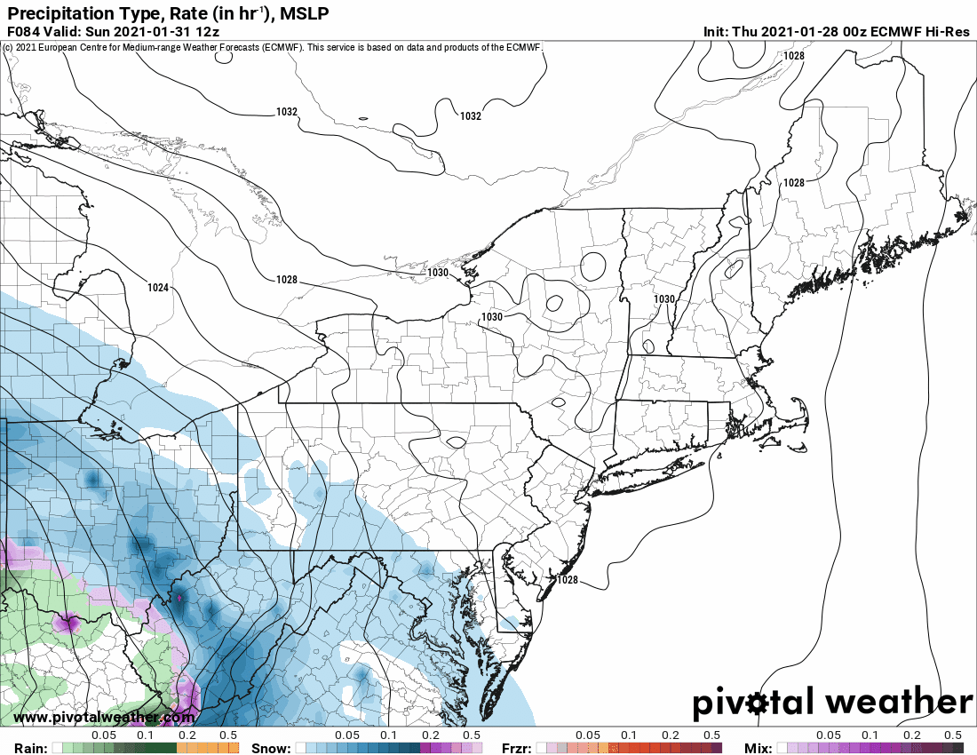
The coastal storm is expected to move north-northeast Monday morning, before running into a strong block to the northeast. This is currently modeled to cause the coastal low to hug the Del-Mar-Va/SNJ coast for 18-24 hours, resulting in long period of moderate snow across the eastern half of PA. We are watching the possibility of some brief sleet in the southern tier, which will depend on when the primary low in the Ohio Valley transfers its energy to the coastal low. The earlier the transfer, the lower likelihood of any sleet. Although there may be a short lull in precipitation Monday morning as the coastal low takes over, we are confident that there will not be a big dry slot like many of us experienced in December. The difference is, with that system, the primary low was much farther north in the OH valley when it transferred energy to the coast. Below is Thursday morning’s evolution of this storm system in our area on the European (ECMWF) model.
While details remain unknown regarding potential snow amounts across the commonwealth, we will tell you there is an increasing probability of widespread travel disruptions Sunday afternoon through Tuesday morning due to this storm. Prepare to reschedule plans during that time if you are located in eastern or central Pennsylvania, because confidence is high that at the very least there will be a plowable snow during that period.
Understand that confidence for a significant to potentially major winter storm is still medium and not yet high. More details regarding expected timing and snowfall amounts for this storm will arrive in the coming days as confidence of a likely solution increase.
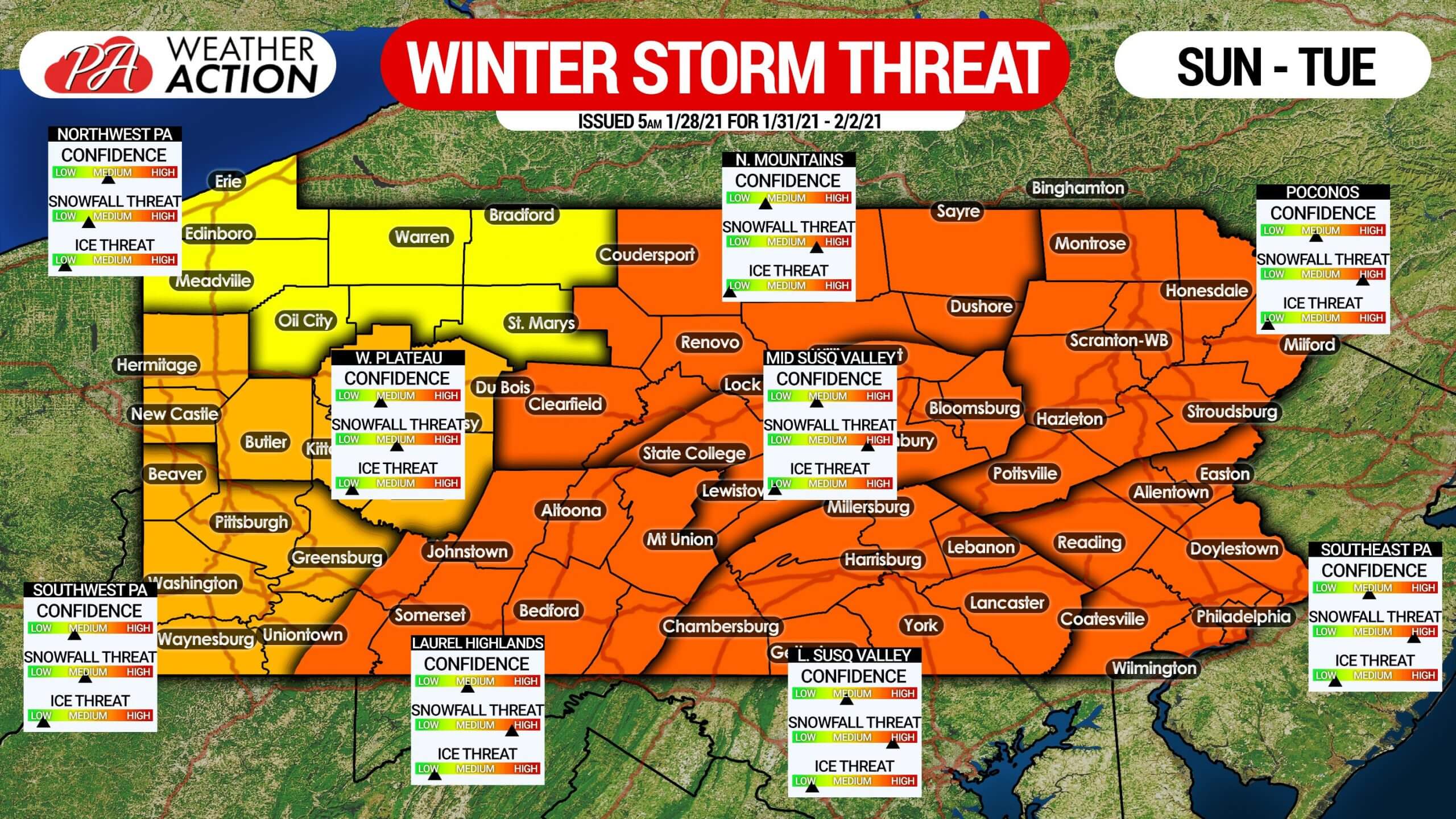
Below is our winter storm threats graphic, showing confidence for different wintry precipitation types across areas of the Pennsylvania. As mentioned, there is the possibility that some sleet may find its way into southern PA before changing back to snow.
We will have another update on this potential high-impact storm with all the latest data at 5:00 PM Thursday. Stay tuned for that, and all the latest updates in the days to come.
The easiest way to get all of our updates and forecasts as soon as they come out is with our free Apple and Android app. Download it here >>> Weather Action App
Don’t forget to share this storm update with your friends and family using the blue button. Stay stay and stay tuned, have a good Thursday.

You must be logged in to post a comment.